President Donald Trump's tariffs are forcing the MBTA to change the way it does business.
www.wcvb.com
General Manager Phil Eng told the MBTA Board on Thursday that the agency is now including new specifications about tariff impacts or other price fluctuations in contract requirements.
"What we want to do is build in specifications that allow for price fluctuations that go up or down," Eng said.
He said the new specifications would apply to "high-quantity components" of large projects, like the North Station Draw One Bridge.
There was no service on the Red Line between Alewife and Park Street this morning between approximately 7:15 and 9:05. Pretty brutal hit during the AM Peak on a Tuesday.
Times like these I think about how important redundancy is, such as GLX to Porter, as a release valve during planned or unplanned shutdowns.
I think it's just wide enough until you get to Porter. From there you'd either need to build out, up, or down. Up is probably best from a cost perspective, out or down is probably best if you want to continue on to Belmont and Waltham.
I think it's just wide enough until you get to Porter. From there you'd either need to build out, up, or down. Up is probably best from a cost perspective, out or down is probably best if you want to continue on to Belmont and Waltham.
What @TheRatmeister said was my prior belief going into this... Until I found that even getting to Porter may possibly be more of a headache than we thought.
Here are the "reasonable maximum" widths that you can get without heavy disruptions:
With a few exceptions, most of this ROW are 46-50 ft wide. Some of these pinch points are building-to-building, and occur throughout the route.
How wide must a ROW be to accommodate 4 tracks? I don't know, but here are two pieces of conflicting evidence.
On one hand, I looked at other quad-tracked parts of the system. I'm inclined to think of 60 ft as a safe requirement for 4 tracks. Some arguments exist for getting down to 57 ft, but they're uncertain and subject to parallex errors, etc.
GLX E branch and Lowell Line:
Per parcel boundaries, the narrowest was 60 ft:
Between Gilman and Magoon (on a curve)
North of Ball Sq
(There's a brief 46 ft section between parcel boundaries just south of Harvard St bridge, but that seems vacuous as one of the parcels overlaps with satellite images of tracks)
Per track boundaries on satellite images, the narrowest was 57 ft:
60 ft at the Gilman-Magoon curve
60 ft at Cedar St bridge
57 ft south of Harvard St bridge
61 ft just north of the Cross St bridge -- but this one has a bit of slack on both sides of GLX tracks, and can possibly be compressed to 57 ft if necessary
Old Colony main line, with RL Braintree Branch involved where applicable:
Per parcel boundaries, the narrowest was 59 ft:
59 ft just south of Redfield St bridge
The parcel boundaries briefly narrow down to 57 ft after that, but it seems somewhat vacuous
60 ft at Walnut St bridge
47 ft for 3 tracks south of Adams St bridge (upscaled to 62.7 ft for 4 tracks)
45 ft for 3 tracks at Granite St bridge (upscaled to 60 ft for 4 tracks)
45 ft for 3 tracks at Hannon Pkwy bridge (upscaled to 60 ft for 4 tracks)
Per track boundaries on satellite images, the narrowest was 58 ft:
61 ft at the Bass River bridge (4 mainline rail tracks)
75-78 ft for 5 tracks north of Sevin Hill station (downscaled to 60-62.4 ft for 4 tracks)
At most 60 ft at the southbound Morrissey Blvd bridge
A bit of slack in both construction and measurements, may narrow down to 55 ft (low confidence)
58 ft at Redfield St bridge
59 ft south of Billings Rd (south of North Quincy), just north of where Old Colony merges back into single track
45 ft for 3 tracks at Hannon Pkwy bridge (upscaled to 60 ft for 4 tracks)
Southwest Corridor:
Per parcel boundaries, the narrowest was ~59.2 ft:
74 ft for 5 tracks at Carter Playground (north of Ruggles, downscaled to 59.2 ft for 4 tracks)
Per track boundaries on satellite images, the narrowest for 4 tracks would be 56 ft, but uncertain:
70 ft for 5 tracks at Carter Playground (north of Ruggles, downscaled to 56 ft for 4 tracks)
77 ft for 5 tracks at and north of Heath St (downscaled to 61.6 ft for 4 tracks)
76 ft for 5 tracks south of New Minton St (north of Green St station, downscaled to 60.8 ft for 4 tracks)
On the other hand, this section along the Fitchburg ROW itself clearly shows traces of a former 3rd track. The space on the other side of the ROW seems similar, meaning a 4th track can possibly fit there. But the ROW is only 49 ft wide here.
49 ft vs. 57 ft seems like quite a big discrepancy. So... I dunno. Perhaps others with more engineering expertise, like @F-Line to Dudley, can explain?
Regardless, this section further west is only 47' wide, and looks even less promising.
Splitting the details of the ROW into two followup comments due to the character limit:
Parcels
Satellite
Reasonable maximum (with simple parcel purchases, parking eliminations, etc.)
Prospect St - Webster Ave
(will need widening regardless)
50 ft
42 ft
arbitrary
Webster Ave - Washington St
50-66 ft
49-66 ft
48 ft or less
Washington St - Dane St
47-54 ft
37-57 ft
46 ft at the turn, 55 ft west of the turn
Dane St - Park St
45-54 ft
50-56 ft
50 ft
Park St - Kent St
52-81 ft
50-75 ft
70-80 ft for the most part, 50 ft or 74 ft to the west
Kent St - Lowell St
52-59 ft with parcel purchase, 45-50 ft without
49-59 ft
49 ft
Lowell St - Beacon St
47-70 ft
47-50 ft
47 ft to the east, 60 ft to the west
Beacon St - before Porter CR
55 ft
50 ft
50 ft
Prospect St - Webster Ave:
Parcel: 50 ft
This includes the Eversource substation, which will need to be dismantled in order to extend the existing GLX tracks
Satellite: 42 ft
Webster Ave - Washington St:
Parcel: 50-66 ft
Immediately west of Webster Ave, thanks to a short elongated MBTA-owned parcel, you get 66 ft
The parcel ends around the 15 Webster Ave building, which is also where residential houses to the south start having backyards and parking immediately bordering the tracks (23-41 Clark St)
50 ft during this entire section, from 23 Clark St to Washington St
Satellite: 49-66 ft
Mostly agree with parcen boundaries (accounting for the MBTA parcel)
Accounting for safety margins would reduce it even further
Washington St - Dane St:
Parcel: 47-54 ft
45 ft at the curve just west of Washington St
West of the curve, narrows from 48 ft (just beyond the curve) to 47 ft right at the Market Basket building
Measurements include an elongated parcel owned by the City of Somerville
The narrowing happens mostly to the north (Market Basket), where the parcel's shape is irregular
West of Market Basket, immediately widens to 54 ft
Satellite: 37-57 ft
37 ft just west of Washington St, which also accounts for crossing the building north of Washington St
Widens to 45-52 ft between the curve and Market Basket; more lenient than parcel measurements
West of Market Basket, 57 ft station-to-station
Reasonable maximum: 46 ft at the turn, 55 ft west of the turn
The section immediately west of Washington St involves a triangular parking lot owned by the City of Somerville, which can be modified with ease; but the "48 ft or less" pinch point crossing Washington St still applies
But then you run into housing on both ends (299 Washington St and 22R Lake St), with 46 ft in-between unless you take over people's backyards
Once you complete the turn, there are a few building-to-building pinch points:
Parcel: 52-59 ft with parcel purchase, 45-50 ft without
There's an elongated parcel parallel to the ROW, owned by YANG ZHITING; I'm not sure if this person is associated with MBTA, but a purchase sounds doable
Without counting the Yang parcel: Starts at 50 ft west of Kent St, but quickly narrows to 45 ft, then widens to 48 ft
Assuming ownership of the Yang parcel: Starts at 58 ft west of Kent St, but quickly narrows to 52 ft, then widens to 59 ft
Pinch Point 2: 49 ft between the two buildings at the Lowell St crossing
That said... At this section, you can clearly see remnants of a 3rd track to the north. Space to the south looks about the same, so perhaps a 4th track can be added. So perhaps fitting 4 tracks in 49 ft may be possible after all?
Lowell St - Beacon St:
Parcel: 47-70 ft
47 ft until the Craigie St parallel
West of the Craigie St parallel, the parcel boundaries quickly widen, and you also have MBTA-owned parcels on both sides, getting comfortably to 70 ft
Narrows to 65 ft at the Beacon St bridge
Satellite: 47-50 ft
The 47 ft part agrees with parcel measurements
West of Craigie St though, the parcels are filled with trees, sidewalks or both
Actual ROW width at Beacon St crossing is 50 ft
Reasonable maximum: 47 ft to the east, 60 ft to the west
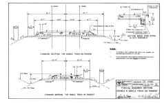
GLX adopts the Commuter Rail Design Standards Manual for its horizontal clearances, so there wouldn't be a mode difference for new construction. Applying math to their schematics for tangent double-track, 49' would be doable if the drainage channels are engineered directly underneath the tracks instead of to the side. That would slightly increase cost and might make utility co-placement a little harder, but it wouldn't affect overall feasibility. Curvature increases the clearance allowance very slightly, but you don't have any curvature on this ROW except for the 46' section north of Washington where some rear parking spots might need to go and Conway Park Station where it's already 70'+. So maybe 3 pinch points total, plus the assumed Porter duck-under.
Doesn't sound fatal at all. If they managed to engineer a 4-track ROW on the Medford Branch with the Community Path in the mix without getting killed on property acquisition costs or controversies, this extension really shouldn't faze anyone.
What @TheRatmeister said was my prior belief going into this... Until I found that even getting to Porter may possibly be more of a headache than we thought.
With a few exceptions, most of this ROW are 46-50 ft wide. Some of these pinch points are building-to-building, and occur throughout the route.
How wide must a ROW be to accommodate 4 tracks? I don't know, but here are two pieces of conflicting evidence.
On one hand, I looked at other quad-tracked parts of the system. I'm inclined to think of 60 ft as a safe requirement for 4 tracks. Some arguments exist for getting down to 57 ft, but they're uncertain and subject to parallex errors, etc.
GLX E branch and Lowell Line:
Per parcel boundaries, the narrowest was 60 ft:
Between Gilman and Magoon (on a curve)
North of Ball Sq
(There's a brief 46 ft section between parcel boundaries just south of Harvard St bridge, but that seems vacuous as one of the parcels overlaps with satellite images of tracks)
Per track boundaries on satellite images, the narrowest was 57 ft:
60 ft at the Gilman-Magoon curve
60 ft at Cedar St bridge
57 ft south of Harvard St bridge
61 ft just north of the Cross St bridge -- but this one has a bit of slack on both sides of GLX tracks, and can possibly be compressed to 57 ft if necessary
Old Colony main line, with RL Braintree Branch involved where applicable:
Per parcel boundaries, the narrowest was 59 ft:
59 ft just south of Redfield St bridge
The parcel boundaries briefly narrow down to 57 ft after that, but it seems somewhat vacuous
60 ft at Walnut St bridge
47 ft for 3 tracks south of Adams St bridge (upscaled to 62.7 ft for 4 tracks)
45 ft for 3 tracks at Granite St bridge (upscaled to 60 ft for 4 tracks)
45 ft for 3 tracks at Hannon Pkwy bridge (upscaled to 60 ft for 4 tracks)
Per track boundaries on satellite images, the narrowest was 58 ft:
61 ft at the Bass River bridge (4 mainline rail tracks)
75-78 ft for 5 tracks north of Sevin Hill station (downscaled to 60-62.4 ft for 4 tracks)
At most 60 ft at the southbound Morrissey Blvd bridge
A bit of slack in both construction and measurements, may narrow down to 55 ft (low confidence)
58 ft at Redfield St bridge
59 ft south of Billings Rd (south of North Quincy), just north of where Old Colony merges back into single track
45 ft for 3 tracks at Hannon Pkwy bridge (upscaled to 60 ft for 4 tracks)
Southwest Corridor:
Per parcel boundaries, the narrowest was ~59.2 ft:
74 ft for 5 tracks at Carter Playground (north of Ruggles, downscaled to 59.2 ft for 4 tracks)
Per track boundaries on satellite images, the narrowest for 4 tracks would be 56 ft, but uncertain:
70 ft for 5 tracks at Carter Playground (north of Ruggles, downscaled to 56 ft for 4 tracks)
77 ft for 5 tracks at and north of Heath St (downscaled to 61.6 ft for 4 tracks)
76 ft for 5 tracks south of New Minton St (north of Green St station, downscaled to 60.8 ft for 4 tracks)
On the other hand, this section along the Fitchburg ROW itself clearly shows traces of a former 3rd track. The space on the other side of the ROW seems similar, meaning a 4th track can possibly fit there. But the ROW is only 49 ft wide here.
49 ft vs. 57 ft seems like quite a big discrepancy. So... I dunno. Perhaps others with more engineering expertise, like @F-Line to Dudley, can explain?
Regardless, this section further west is only 47' wide, and looks even less promising.
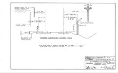
Specifically, the GL standards call for 11' per track minimum spacing on center, 12' preferred net of catenary poles and fencing. Much of GLX was built to 11'6", so it's probably safe to say 24' inclusive of poles. Double Commuter Rail track is specified at 13' on center, 8'6" min (12' preferred) net of side obstructions. I think the problem is they're engineered it as two parallel but separate RoWs, with individualized clearance requirements for both GL & CR, likely for maintenance reasons. Based on those numbers, I get a minimum of 52 feet. Add back some space for catenary and signals, and 58-60' is your mark.
Looking at the GLX cross section, it appears they settled on 55'6" as their minimum cross section for the NH Main + GLX, and similar makes sense for GLX Porter and Fitchburg.
I think the problem is they're engineered it as two parallel but separate RoWs, with individualized clearance requirements for both GL & CR, likely for maintenance reasons.
Yeah. Keeping the CR mode operating--and operating at nearly full double-track capacity--during the week throughout construction definitely widened the clearance tolerances a lot for that project. The most they could do around a weekend outage was temp-move short lengths of CR track around discrete construction zones; they couldn't dig under and re-engineer the entire trackbed at once to do things like self-contained drainage channeling. If you could stand to have the Fitchburg Line truncated to a Porter-Wachusett shuttle for several months at a time and use the Alewife maintenance yard as a temp inner layover, you would probably be able to engineer a significantly narrower ROW at the pinch points by virtue of having the full ROW all available at once for construction activities in 3 dimensions down to the soil base.
Specifically, the GL standards call for 11' per track minimum spacing on center, 12' preferred net of catenary poles and fencing. Much of GLX was built to 11'6", so it's probably safe to say 24' inclusive of poles. Double Commuter Rail track is specified at 13' on center, 8'6" min (12' preferred) net of side obstructions. I think the problem is they're engineered it as two parallel but separate RoWs, with individualized clearance requirements for both GL & CR, likely for maintenance reasons. Based on those numbers, I get a minimum of 52 feet. Add back some space for catenary and signals, and 58-60' is your mark.
Looking at the GLX cross section, it appears they settled on 55'6" as their minimum cross section for the NH Main + GLX, and similar makes sense for GLX Porter and Fitchburg. View attachment 62655
Working off this, if we assume that each GL track is 11' wide (minimum spacing, narrower than the eventual design), each CR track is 13' wide, no additional clearance outside any tracks (even the two outmost tracks), and catenary and signal poles take no space, we get... 48 feet.
So yeah, looks like that might be doable for the 49' segments, with the caveat that any additional clearance requirements would likely be extremely tricky.
Could the 13' spacing for CR be plausibly reduced, or is that already the bare minimum? I'm having trouble reconciling the clearly different design standards for GL and CR tracks in the charts above, versus F-Line's comment here:
The morning commute on the MBTA’s Red Line went up in smoke Tuesday. Riders were diverted to shuttle buses while the Cambridge Fire Department investigated "a reported extinguished fire" in a train tunnel.
www.masslive.com
Train service was paused and riders were diverted to shuttle buses after a report of smoke coming from the area between Porter and Harvard stations in Cambridge, the T said.
So yeah, looks like that might be doable for the 49' segments, with the caveat that any additional clearance requirements would likely be extremely tricky.
Instead of trying to cram in the 4 tracks and engineer a new Porter platform above or below (which seems to me like the biggest headache of this whole thing), would it be possible to single-track the Fitchburg line between Union and Porter? This way, you have a lot more breathing room through the corridor and with some reworking of Porter maybe you could even fit both CR and GL platforms on the same level (not parallel of course, but perhaps either side of the current mezzanine. Or maybe even reconfigure and shrink the CR platforms for GL use).
We've talked here about how single track is doable for RER frequency as long as the segments are short and there are stops on either end to time trains. The Salem tunnel, to be specific, is about 0.8 miles of single track from what I can tell (but about 1.4 miles from the proposed South Salem station to where it is double-tracked again north of Salem station. Union to just past Porter, where the ROW is large enough for 4 tracks, is 1.4 miles. Coordinating this segment all the way from North Station seems like a mess and I've read F-Line's post about why a Union Square infill is a hard no for now. However, I'm curious to y'all's opinions on whether it would be possible/preferred to sacrifice one CR track, build Union Square CR infill, and slightly rework Porter on one level, compared to trying to fit 4 tracks down the ROW and create a whole new level for platforms somewhere around Porter.
Or potentially a hybrid model where there is a Regional Rail passing track somewhere in the ROW between Porter and Union (assuming some part of the ROW is a bit wider)?
Yeah. Keeping the CR mode operating--and operating at nearly full double-track capacity--during the week throughout construction definitely widened the clearance tolerances a lot for that project. The most they could do around a weekend outage was temp-move short lengths of CR track around discrete construction zones; they couldn't dig under and re-engineer the entire trackbed at once to do things like self-contained drainage channeling. If you could stand to have the Fitchburg Line truncated to a Porter-Wachusett shuttle for several months at a time and use the Alewife maintenance yard as a temp inner layover, you would probably be able to engineer a significantly narrower ROW at the pinch points by virtue of having the full ROW all available at once for construction activities in 3 dimensions down to the soil base.
It would be interesting (and probably impossible to get it going so quickly) to do this along with the Draw One bridge project at North Station. I think they're going to keep all 4 tracks over the Charles running during weekdays and 2 tracks on the weekends during the construction of the bridge (10 years?). In a perfect world where projects could start tomorrow, couldn't it help both projects if they happened at the same time?
Instead of trying to cram in the 4 tracks and engineer a new Porter platform above or below (which seems to me like the biggest headache of this whole thing), would it be possible to single-track the Fitchburg line between Union and Porter? This way, you have a lot more breathing room through the corridor and with some reworking of Porter maybe you could even fit both CR and GL platforms on the same level (not parallel of course, but perhaps either side of the current mezzanine. Or maybe even reconfigure and shrink the CR platforms for GL use).
We've talked here about how single track is doable for RER frequency as long as the segments are short and there are stops on either end to time trains. The Salem tunnel, to be specific, is about 0.8 miles of single track from what I can tell (but about 1.4 miles from the proposed South Salem station to where it is double-tracked again north of Salem station. Union to just past Porter, where the ROW is large enough for 4 tracks, is 1.4 miles. Coordinating this segment all the way from North Station seems like a mess and I've read F-Line's post about why a Union Square infill is a hard no for now. However, I'm curious to y'all's opinions on whether it would be possible/preferred to sacrifice one CR track, build Union Square CR infill, and slightly rework Porter on one level, compared to trying to fit 4 tracks down the ROW and create a whole new level for platforms somewhere around Porter.
The Porter platform would have to be double-track to fit :15 service on the inner Fitchburg Line, and that puts you immediately out of space here to squeeze the Green Line at-grade. There will definitely be opposite-direction meets around stopped trains with a schedule that dense. The Salem tunnel isn't an applicable comparison, as that's a very short length where in-motion trains clear the single-track within seconds. The Salem comparison that matters is "Does the Salem mainline platform need to be doubled up?" to achieve :30 Rockport + :30 Newburyport = :15 Salem service. That answer is very likely a yes at Salem, and almost certainly a yes at Porter.
"Does the Salem mainline platform need to be doubled up?" to achieve :30 Rockport + :30 Newburyport = :15 Salem service. That answer is very likely a yes at Salem
They might have to take a sidewalk/path from the adjacent condo complex to make the new outbound side platform fit, but yes it's fully feasible. And they probably don't have a choice given that the odds of an opposite-direction meet with branching :15 service are so high.

 www.wcvb.com