Green Line Extension to Medford & Union Sq

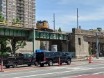
Is it me, or is that bridge height kind of low?

15 ft. That's only a foot underheight by default MassHighway clearance standards, 3 ft. taller than the old span, and 1'1" taller than the adjacent McGrath Overpass.
 
Is it me, or is that bridge height kind of low?
It's not terrible, I believe it is 15 feet which is acceptable for a collector or medium arterial, and there are some real grade constraints for the tracks, the tracks cross under roadways on either side of this bridge within a few hundred feet, so you really can't change the track height much without also changing those bridges. As for the roadway going down, I don't know about utility restrictions etc, but not worth it for the MBTA to spend money on for no benefit. It fits a bus easily so thats all they need.
 
Is it me, or is that bridge height kind of low?
I think the width makes it look lower. It is actually 1' higher than "minimum standard" (though I bet it will get another 3" top coat of asphalt before this is all done?) and probably end up at 14' 9" (my guess)

There's a temporary sign on the bridge saying its clearance is 15' (see my post, above)
The FHWA standard for collector-local bridge underclearance is 14' (minimum), and 14' ~ 16' on arterial-highway types.
I could easily believe that 16' is MassDOT standard

And, here, you also have to consider the costs of how much higher/thinner they could raise the bridge without adding too much embankment cost to the railroad grades, above

Other normal values:

13'6" is the max for "standard highway truck" max height on level ground, but there's no official max truck height (rather it is the job of truckers to just "not hit stuff", a job that is made easier if you're never more than 13'6"...always a thrill to see a 13'6" truck go under a 14' bridge "at speed")

13' is the standard "municipal" tree-trimming height is 13' off the pavement (and 8' off a sidewalk, but also as low as 9' off a street, but which results in truck-strikes)
 
Last edited:
This looks like the biggest undertaking since moving the Orange line over to the southwest Corridor or the Big Dig!!
 
Last edited:
It also reminds me of the expressway and turnpike construction in the Boston area in the 1950's and 60's.
 
It's not terrible, I believe it is 15 feet which is acceptable for a collector or medium arterial, and there are some real grade constraints for the tracks, the tracks cross under roadways on either side of this bridge within a few hundred feet, so you really can't change the track height much without also changing those bridges. As for the roadway going down, I don't know about utility restrictions etc, but not worth it for the MBTA to spend money on for no benefit. It fits a bus easily so thats all they need.

The road under the old bridge used to flood like a sonofabitch during bad downpours because of the severity of the roadway's 'dip' around the 1890's grade crossing elimination. I can recall some hairy moments walking there in rainstorms back when I lived up Myrtle St. where the water would pool up to the lip of the sidewalk and come cresting over in waves whenever a driver attempted to plow through the 2 ft. of water on the roadway. I got soaked as a pedestrian, but I was amazed that more cars didn't get stranded in the fast-rising water. It was a legit scary sight during a torrent.

The new finished road is going to require massively upgraded storm drains to handle the increased clearance, but given the severity of the grades around the 'dip' it's pushing the physical limits of how much water is possible to passively drain before gravitational effects from the 'dip' simply overpower it. The 1 ft. difference between the current 15 ft. underclearance and the 16 ft. reference standard that requires no sign-posted limit is probably inclusive of the outer limits of practical storm drainage vs. any more roadway undercutting. It's always going to be a problem spot during flash flooding. The hope is simply that they've improved drainage enough that it's no longer the outright danger spot the old undergrade was.
 
I haven't seen (to my memory) a clear explanation of what happens with the community path at the McGrath Hwy bridge. Has anyone else? Does the path go underneath it or meet it at grade with a very nasty crosswalk?
 
It goes underneath it, and there's a connector from street level.
 
The road under the old bridge used to flood like a sonofabitch during bad downpours because of the severity of the roadway's 'dip' around the 1890's grade crossing elimination. I can recall some hairy moments walking there in rainstorms back when I lived up Myrtle St. where the water would pool up to the lip of the sidewalk and come cresting over in waves whenever a driver attempted to plow through the 2 ft. of water on the roadway. I got soaked as a pedestrian, but I was amazed that more cars didn't get stranded in the fast-rising water. It was a legit scary sight during a torrent.

The new finished road is going to require massively upgraded storm drains to handle the increased clearance, but given the severity of the grades around the 'dip' it's pushing the physical limits of how much water is possible to passively drain before gravitational effects from the 'dip' simply overpower it. The 1 ft. difference between the current 15 ft. underclearance and the 16 ft. reference standard that requires no sign-posted limit is probably inclusive of the outer limits of practical storm drainage vs. any more roadway undercutting. It's always going to be a problem spot during flash flooding. The hope is simply that they've improved drainage enough that it's no longer the outright danger spot the old undergrade was.

I'm no "pro" with pump stations and their effectiveness, but shouldn't that alleviate the drainage here?
1591220390961.png
 
Harvard St underpass (Som/Med line midway between Ball Sq & Tufts) got a similar "track lift & drainage boost" in Phase 1A (pre-work) and has been a huge boon to neighborhood drivers.
 
I'm no "pro" with pump stations and their effectiveness, but shouldn't that alleviate the drainage here?
View attachment 5500

Should. Everything in that neighborhood is very flood-prone (flash flood, not storm surge...so high-frequency/low-severity of exploits and at least 1-2 guaranteed annual FUBAR's after a monsoon rain). Though looks like from the under-track piping the lower Somerville Ave./Medford St. area is the primary target for the pumphouse. Which makes sense. Medford St. Bridge undergrade is an even bigger house of horrors than Washington for pooling floodwater. I remember that street being barricaded for days after Hurricane Irene from standing water that went well above highest sidewalk level just a few feet under the girders.
 
Should. Everything in that neighborhood is very flood-prone (flash flood, not storm surge...so high-frequency/low-severity of exploits and at least 1-2 guaranteed annual FUBAR's after a monsoon rain). Though looks like from the under-track piping the lower Somerville Ave./Medford St. area is the primary target for the pumphouse. Which makes sense. Medford St. Bridge undergrade is an even bigger house of horrors than Washington for pooling floodwater. I remember that street being barricaded for days after Hurricane Irene from standing water that went well above highest sidewalk level just a few feet under the girders.

Found an interesting presentation on the Union Square/Somerville Ave projects and their effects on flood models made by Somerville's director of infrastructure.

Some tidbits:
- Looks like the models presented still expect Washington and Medford St crossings to still flood.
- They specifically call out Somerville's $50 million GLX contribution.

Curious what the $50 million really got the city during negotiations.
 
Curious what the $50 million really got the city during negotiations.

Private IOU's to stop dragging feet on McGrath teardown, I bet. Other than continued follow-thru pressure for making sure the Mystic Valley Parkway GLX phase proceeds briskly apace, STEP's new #1-with-a-bullet advocacy and existential cause is the boulevardizing of McGrath. And they are loaded for bear--now with intimidating decade-long winning record in-tow re: hand-to-hand combat with MassDOT and the Gov.--on making sure no one starts lollygagging it on the main slate of big-picture decisions that have to be made on it. There has to be a furious quantity of quid pro quo's being actively exchanged behind the scenes.
 
^
Elevated steel and concrete structure between Gilmore Bridge and Lechmere Station to be removed, relocated, and reconstructed.
(underline mine)
Reconstructed? Where?
Would make a great trail bridge!
 
And so the demolition begins. Lechmere wasn't as flattened as I expected when I walked by today but I suspect it will be soon.
 

Attachments

  • IMG_20200606_124419.jpg
    IMG_20200606_124419.jpg
    3.3 MB · Views: 317

Back
Top