Here are my comments on both
Van's initial proposal (in the UR thread but really talking about GLR more than UR), and Riverside's comments above.
Engineering and detailed route design
This is closer to the current proposal, and leans on what was, at the time, the more common proposal to build a subway under Stuart St. But, again interestingly, this proposal would require modifications to the (now disused) Tremont Street Subway, to add an additional flying junction. The current proposal takes advantage of the existing flying junction at the Pleasant St Portal, once again eliminating the need to modify existing infrastructure.
While the consensus has shifted towards a Marginal St subway now and for good reason, I don't think Stuart St has ever been fully off the table. We're
speculating that Marginal will be easier to build, but Stuart will always be a backup option and probably Alt #2 in any real-world plans. Even
F-Line in 2021 completely agreed with this.
A Stuart-Kneeland alignment from Back Bay all the way to Seaport will likely see less certain utility relocations
(though Marginal isn't completely without utility either, they're just better mapped), and of course, has the problem of needing to modify the Tremont St tunnel. But Marginal has its own risk factors:
- Much narrower than Stuart, often with decently tall buildings. (That section has always concerned me.)
- Needing to interfere with OL/CR Back Bay station. While it offers a better transfer, it does bring engineering uncertainties, and possible political uncertainties dealing with MassDOT for digging under the Pike.
- Dealing with Hudson St and/or the Big Dig tunnel (Dewey Square tunnel), which I've been increasingly concerned about -- even though I do think multiple alternatives exist.
Some of these are reasons why
I occasionally lean towards Stuart now, especially for the eastern half (Kneeland).
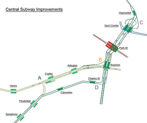
But I think this does draw attention to a feature of the current GLR concept that we take for granted: other than signal and platform improvements, and potentially aside from some crossover installations at Park St, the existing Central Subway does not get touched at all. There are no rebuilds, no underpinning, no modifications to existing tunnels. For a project that is geared in part at increasing capacity, I think that's actually pretty notable.
In particular, the magical moment is when you realize that (1) Boylston-Park has 4 tracks, but we only use two; (2) Pleasant St Incline, an entire 1200' tunnel with its own freaking flyover and a former portal, just exists right there. Honestly, these two reasons are why I'm utterly surprised with how attention to GLR is almost entirely limited to this forum, especially due to (1). I mean, has no one else looked at the track diagram and thought "maybe we could use the quad-tracked Boylston-Park somehow"?
(Though, to Reddit's credit, someone was talking about "Stuart St realignment" the other day, presumably regarding the same idea.)
I mean, I gotta say, even 16 years later, this plan slaps. It would be wildly expensive and even with fantastic sums of money would probably be impossible in places, but, just, I mean, damn. Grade separating the Brattle Loop is something that I haven't thought about in a long time, and is piquing my curiosity. I don't rely on the Brattle Loop as much as I used to in my designs, and I'm not sure that grade separation actually buys you that much, but it's still interesting to consider.
While it should be very obvious that any proposal for quad-tracking Park-GC under Tremont St
(50' building-to-building between 10-story-high buildings) is effectively a non-starter... I must say, the idea of it is still absolutely wild. And the benefits of quad tracking here are also pretty obvious: Making the Central Subway more like a "real" line, instead of a "stub" that terminates at Park St. The need to turn all of them at Park has really bothered me, especially when considering that GC
(part of "Greater Haymarket") itself is a major employment center and tourist destination.
If grade-separating Brattle Loop is your concern, though: Can we
bulldoze C&C under City Hall Plaza to straighten out the Haymarket-GC segment, like this?
Probably still very expensive and disruptive, but it has two main benefits:
- Easily set up 4 tracks towards GC that are much closer together than before: you can then have 2 inner tracks terminating at GC, resurrecting Brattle "Loop", while 2 outer tracks continue to Park
- Straightens the tight curves around Haymarket and GC: not just the non-revenue 50' Brattle Loop, but also the 60' revenue track southbound entering GC
- May even allow far-future HRT conversion of GLR (depending on North Station-Science Park curves)
More abstract route design (GLR only)
This tunnel would then continue to South Station and on to South Boston, there by connecting the hotels, offices, and convention center of the new SBW with the hotels, offices, and convention center of the Back Bay (through the Financial District!)
Gotta be honest, there was a point recently where I was doubting the value of a Back Bay-South Station-Seaport connection.
Especially when I was wondering if commuter rail riders needing a transfer to Back Bay may simply take another commuter rail train instead (especially with NSRL).
But this totally convinced me, and this way of explaining the importance of a Back Bay-Seaport route is understated.
(I've certainly seen visitors living in Back Bay hotels who want to visit Seaport, but gave up because of how tedious the transit trip is.) And Van's comment didn't even begin to consider LMA.
Overall, I'd argue this original plan had three key pieces, two of which we address directly today:
- Eliminating Copley Junction
- Redirecting one or more services away from Park St to the Seaport
- Expand capacity between Park St and Government Center
It's that last one that has proven to be immovable. Just nowhere to put a tunnel that doesn't blow a lot of stuff up. But we've tried to address Park <> GC capacity with other, more indirect measures:
I myself am actually not too concerned about
capacity between Park-GC, if that's the origin-destination pair we're talking about. Orange Line almost does that, and Tremont St subway can at least see the exact same number of trains under GLR as it does today. Even now, I doubt GC-Park is the capacity bottleneck: I'd think the most severe overcrowding is west of Park St.
High-level philosophy
I realize that all I wanted to say here are really comments on Urban Ring and not GLR, so
I've moved them to the Urban Ring thread.