Love that this is being worked on - but it feels like those renderings with trees all over the sides of buildings. This whole plan is heavy on city upkeep, and most trees likely to die being still in such a road corridor - who knows if they'll be replaced. Where is the bus lane? Where are the areas for residential development? Why keep local access Dana and Edmands streets? Biggest demonstration the there is still a canyon designed into this plan is that there 2 x 2-way cycle tracks across the street from each other.
You are using an out of date browser. It may not display this or other websites correctly.
You should upgrade or use an alternative browser.
You should upgrade or use an alternative browser.
Grounding the McGrath
- Thread starter BostonUrbEx
- Start date
Aprehensive_Words
Active Member
- Joined
- Oct 18, 2022
- Messages
- 278
- Reaction score
- 543
This, 1,000 times.Funny how you mentioned bus infrastructure, because it looks like bus lanes are entirely missing from this design. Especially when the T plans to introduce a BRT route SL6 that runs via this section of McGrath, citing the redesign process as part of the consideration, and said "almost the entirety of this alternative would operate on dedicated bus lanes".
Hopefully someone like @StreetsblogMASS or the Boston Globe can flag this issue ASAP.
RandomWalk
Senior Member
- Joined
- Feb 2, 2014
- Messages
- 3,713
- Reaction score
- 6,498
I thought they mentioned that transit priority was considered and rejected for knock-on effects on the system.
Narrowing the right of way won’t yield much difference. If you handed it over to development, existing properties blocked by the new properties would scream bloody murder. If you did a larger redevelopment of the existing frontage and bordering properties, folks outside the redevelopment would scream.
Narrowing the right of way won’t yield much difference. If you handed it over to development, existing properties blocked by the new properties would scream bloody murder. If you did a larger redevelopment of the existing frontage and bordering properties, folks outside the redevelopment would scream.
Equilibria
Senior Member
- Joined
- May 6, 2007
- Messages
- 7,219
- Reaction score
- 8,728
I notice they've proposed eliminating left turns from McGrath onto Washington Street in both directions... I kind of get the NB one since they want you to take Somerville Avenue instead, but what's the alternative to the SB left onto EB Washington?
ball_square
Active Member
- Joined
- Nov 14, 2023
- Messages
- 277
- Reaction score
- 824
Even as someone who bikes in Somerville a lot... does anyone know what warrants two two-way cycletracks, rather than one two-way or two one-way tracks?
I would rather one of those tracks and some green space be traded in for median bus lanes.
fattony
Senior Member
- Joined
- Jan 28, 2013
- Messages
- 2,099
- Reaction score
- 482
Somerville employs not just one, but two arborists. Tree stewardship is something Somerville has been doing relatively well in recent years. I was initially devastated when they cut down the tree in front of my house and others on my block. When I contacted the city about it I received a coherent response with a holistic approach to tree health throughout the city. The thing about trees though is that they last a long time (or are supposed to). Let's see if the city's diligence lasts as long.Love that this is being worked on - but it feels like those renderings with trees all over the sides of buildings. This whole plan is heavy on city upkeep, and most trees likely to die being still in such a road corridor - who knows if they'll be replaced.
Teban54
Senior Member
- Joined
- Nov 13, 2021
- Messages
- 1,142
- Reaction score
- 2,856
This will also be an issue for the 90 bus, which needs to get from Highland Ave to Cross St, while also stopping at the McGrath/Washington intersection so that it can get reasonably close to East Somerville GL station.I notice they've proposed eliminating left turns from McGrath onto Washington Street in both directions... I kind of get the NB one since they want you to take Somerville Avenue instead, but what's the alternative to the SB left onto EB Washington?
JeffDowntown
Senior Member
- Joined
- May 28, 2007
- Messages
- 5,006
- Reaction score
- 4,126
Does it appear this way to anyone else, that perhaps one part of MassDOT (highways) needs to talk to the other part of MassDOT (MBTA)?
Charlie_mta
Senior Member
- Joined
- Jul 15, 2006
- Messages
- 5,088
- Reaction score
- 7,612
Absolutely essential to include bus lanes (in both directions), and also bus-only left turns onto Washington St from McGrath Hwy for busses as mentioned above.Two travel lanes is an improvement, but no bus lanes and I'm still seeing monster 6-lane intersections
View attachment 47635
Even as someone who bikes in Somerville a lot... does anyone know what warrants two two-way cycletracks, rather than one two-way or two one-way tracks?
I would rather one of those tracks and some green space be traded in for median bus lanes.
As others are noting, the ROW is still quite wide. Even with the dramatic improvement of demolishing the elevated highway, people are likely to have a strong preference not to cross the street if they don't have to. Also, with the wide planted buffers shown in this cross-section, the bike lanes are likely to feel a bit like shared use paths. Those are typically bi-directional, and I bet people would ride both directions in them regardless of whether it's signed one-way or two-way.
ball_square
Active Member
- Joined
- Nov 14, 2023
- Messages
- 277
- Reaction score
- 824
That makes sense. If they're proper shared-use paths, though, then are the sidewalks necessary?As others are noting, the ROW is still quite wide. Even with the dramatic improvement of demolishing the elevated highway, people are likely to have a strong preference not to cross the street if they don't have to. Also, with the wide planted buffers shown in this cross-section, the bike lanes are likely to feel a bit like shared use paths. Those are typically bi-directional, and I bet people would ride both directions in them regardless of whether it's signed one-way or two-way.
StreetsblogMASS
New member
- Joined
- May 26, 2023
- Messages
- 69
- Reaction score
- 427
Here's our write-up of the public hearing last night:
 mass.streetsblog.org
Somerville's 'Grounding McGrath' Plan Has A New Look, With Fewer Lanes - Streetsblog Massachusetts
A plan to transform Somerville’s McGrath Highway into a narrower, tree-lined boulevard is getting closer to reality. At a virtual public hearing on Tuesday evening, officials from MassDOT and the City of Somerville announced that work to demolish the obsolete highway could begin by 2028...
mass.streetsblog.org
StreetsblogMASS
New member
- Joined
- May 26, 2023
- Messages
- 69
- Reaction score
- 427
This, 1,000 times.
Hopefully someone like @StreetsblogMASS or the Boston Globe can flag this issue ASAP.
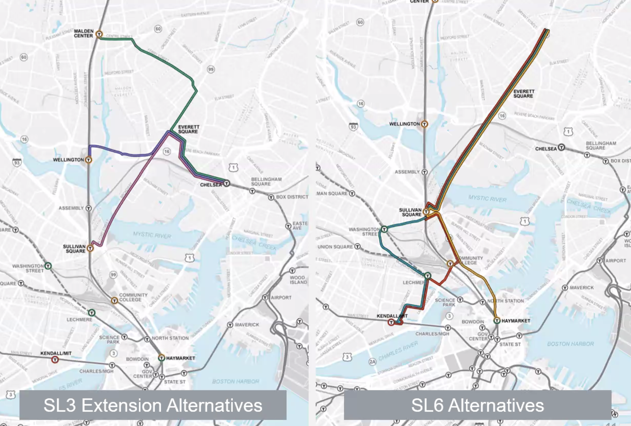
Bus lanes definitely came up last night during the Q&A. The project team says they're not included (for now) because neither the Bus Network Redesign nor the Silver Line extension study flagged McGrath as a priority route for high-frequency bus service.
Of the six shortlisted SLX alternatives, only one might have used McGrath, and only on the segment south of Washington St.
The SLX study still hasn't officially IDed a preferred alignment, but the City of Boston's decision to build center-running bus lanes on Rutherford Avenue probably seals the deal. Rutherford also has a much higher capacity for new transit-oriented development.
That said, the project designers emphasized that the street design is adaptable and there's plenty of space to accommodate bus lanes in the future.
I think this may be an unstated (implied) determination that one of the Rutherford alternatives is the preferred SL6 alternative.
That being said, I think that with all the space left over from the Washington Street intersection with Medford/McGrath, that there's not a short section of centered bus lanes and boarding islands seems wild.
That being said, I think that with all the space left over from the Washington Street intersection with Medford/McGrath, that there's not a short section of centered bus lanes and boarding islands seems wild.
Teban54
Senior Member
- Joined
- Nov 13, 2021
- Messages
- 1,142
- Reaction score
- 2,856
During one of the SLX community engagement meetings back then, they mentioned they were in favor of the McGrath alignment over Rutherford. (Though, to be fair, that was before the Rutherford redesign fully committed to bus lanes.)Bus lanes definitely came up last night during the Q&A. The project team says they're not included (for now) because neither the Bus Network Redesign nor the Silver Line extension study flagged McGrath as a priority route for high-frequency bus service.
Of the six shortlisted SLX alternatives, only one might have used McGrath, and only on the segment south of Washington St.
The SLX study still hasn't officially IDed a preferred alignment, but the City of Boston's decision to build center-running bus lanes on Rutherford Avenue probably seals the deal. Rutherford also has a much higher capacity for new transit-oriented development.
That said, the project designers emphasized that the street design is adaptable and there's plenty of space to accommodate bus lanes in the future.
If the Rutherford alignment does play out, I'm worried about Gilmore Bridge, though. It's not part of the redesign, and looks like it gets a lot of traffic.
Last edited:
I didn't mean to imply that this design had shared use paths, only that the wide & green-buffered bike lanes might "feel" sort of like a path. Sorry if there was any confusion.That makes sense. If they're proper shared-use paths, though, then are the sidewalks necessary?
Shared use paths carry distinct accessibility requirements that do not apply to bike lanes (one-way or two-way). The proposed design is very much for two-way bike lanes and would probably require significant modification meet accessibility regs for a path. In general, in busy urban areas, separate facilities for bikes and pedestrians are preferable. IMO, two-way bike lanes and sidewalks on both sides are desirable for most ROWs, including this one.
ball_square
Active Member
- Joined
- Nov 14, 2023
- Messages
- 277
- Reaction score
- 824
Makes sense @Codman89 . You weren't implying that they were shared-use paths in this design. My thinking was that if they *could* be widened into shared-use paths, then eliminating the sidewalks would lead to a net savings in width, thus allowing for bus lanes.
Regardless, from what @StreetsblogMASS reports, it sounds like they thought about bus lanes and are intentional in not including them now, which satisfies me. Overall, I'm psyched about the project.
Regardless, from what @StreetsblogMASS reports, it sounds like they thought about bus lanes and are intentional in not including them now, which satisfies me. Overall, I'm psyched about the project.
Another problem with the bike lanes is it looks like they're not actually protected all the way. The bridge over the train tracks just has painted bike lanes. Some intersections are good, but protection around Medford St. or Broadway just disappears, exactly where you need it most.
With that and all the other criticisms in mind, I want to emphatically say, this is great. This plan is so much better than what's there and even better than previous plans. Any kind of iterative improvements are basically impossible while the elevated highway is still there. Tear it down, build this, fix it later.
With that and all the other criticisms in mind, I want to emphatically say, this is great. This plan is so much better than what's there and even better than previous plans. Any kind of iterative improvements are basically impossible while the elevated highway is still there. Tear it down, build this, fix it later.
Because the government never, ever actually gives space back. They cancel the interstate but leave the ROW. It's a real shame there isnt more agility in the way these things are planned, but look at Melnea Cass, look at Govt Center/City Hall. There is never any consideration of actual land use change, fundamentally, the redesigns of these places always retain the footprint of whatever it is theyre putatively fixing. The skeleton is the same.I was able to attend the meeting. A big question that arose for me was: why fill the existing right-of-way with more road infrastructure (medians, verges, parallel frontage/local access roads, and long driveway access cuts) just cause there's the space to?
A lot of what was shown seems to aim to keep the existing width of the corridor, doing little to stitch back together the urban fabric it tore through upon construction. Why not cede some of the remaining space after the road diet + bike lanes + bus infra. to development that's better in scale with the scale of the McGrath corridor? Upzone abutters and yield some of the corridor to create space for development. Development along the corridor (of a denser variety) would help shield the surrounding quiet neighborhoods from traffic noise and direct exhaust, while better framing the wide Blvd., and would help stich together the surrounding neighborhoods.
The presenters highlighted the new 'green space' that was being created, but... it's still going to be alongside or in the middle of regular McGrath traffic volume and speeds...
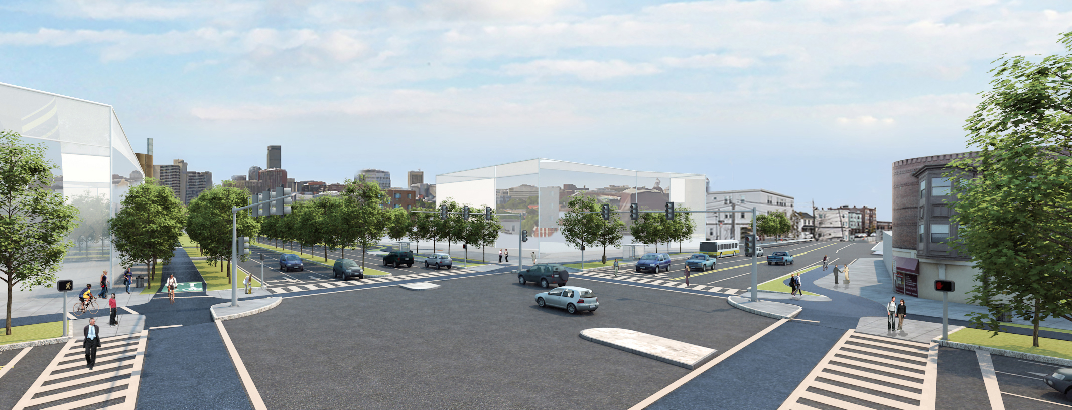
Here are the main 'design' slides I captured from the meeting:
This project looks alright to me, but the other thing you seem to never see is a legit greenway. Having three buffers that are wide enough for single trees is a recipe for salted, dead trees and doesnt do anywhere near as much as if they had two buffers, or even one, wide enough for multiple trees deep. I dont know why we seem to always have fixations with the image of greenspace, rather than greenspaces that actually are real greenspaces. Having a linear forest and putting all the road stuff on one side would be far more audacious, better from an ecological standpoint, and might actually get some use beyond just looking at and passing through.