Hartford CT

Arlington

Moderator
Staff member
Joined
Dec 10, 2011
Messages
5,599
Reaction score
2,696
The I-84* vaiduct can't last, but does it need to be there at all?

The Downtown Highway That Could Drive Hartford’s Comeback

I think the solution is Urban boulevards (downtown) and a toll road an HSR (HFD-PVD on the original/unused/preserved I 84 alignment)so that the Acela can run a fast, straight "L" NHV-HFD-PVD instead of it's slow and less-populated coastal routing.

*Corrected.
 
Last edited:
I-84, known locally as the "Aetna viaduct" because of the way it snakes around the insurance company's headquarters on its way toward downtown Hartford.

Picture in below link

 
I- 84 viaduct, sorry, corrected.

(OT: I-81 in Syracuse is similarly old and unwanted and potentially going to be torn down and replaced but an upgraded bypass route))

It really underscores how lucky (powerful) Mass politicians were to get an override of a Reagan veto in 1987 to start funding on our Big Dig. Partly it was just timing having been a pioneer of elevated Urban freeway, we were the first to see it obsolescence.

For I-84, I would move the 84 badge onto I-691-91-CT15 in their eastern bypass of the city, and then build Urban boulevards instead of today's West side viaduct.
 
Last edited:
Where would you stop the current I-84 coming from the west? I assume you would leave it as some kind of spur and then switch to boulevards near the city line? I can't imagine a downgrading scenario that wouldn't make West Hartford furious, but given how much highway coverage there actually is in this area, it seems like very few places would be put out by more than 10 minutes in travel time. You mentioned a toll road too but I guess I can't picture how that, a boulevard and HSR are all supposed to fit in this corridor through Hartford proper.
 
I- 84 viaduct, sorry, corrected.

(OT: I-81 in Syracuse is similarly old and unwanted and potentially going to be torn down and replaced but an upgraded bypass route))

It really underscores how lucky (powerful) Mass politicians were to get an override of a Reagan veto in 1987 to start funding on our Big Dig. Partly it was just timing having been a pioneer of elevated Urban freeway, we were the first to see it obsolescence.

For I-84, I would move the 84 badge onto I-691-91-CT15 in their eastern bypass of the city, and then build Urban boulevards instead of today's West side viaduct.

Maybe a better solution....re-badge Route 9 from Farmington to Cromwell as I-84; Dual Badge 91 North to Exit 29 - Charter Oak Bridge and rebadge Route 15 until it joins the current I-84 allignment in East Hartford.

Have I-84 from the current Route 9 to the Flatbuch avenue renamed to a 3 digit interstate (584?) and then urban boulevard from Flatbush - have it roughly follow the current I-84 allingment - and have it outlet onto the Bulkley Bridge.
 
Rerouting 84 makes all the sense in the world. Theres no reason all the through traffic between boston and New York should be driving right through downtown hartford, and the 691 alignment according to google maps is -no time difference-. A spur towards Hartford can probably remain and terminate around West Hartford before turning into a Blvd. I don't think WHartford is going to be as opposed to this as people believe. Light rail along Farmington Ave would really help any connectivity concerns but that probably won't be on the table.

I'll leave the HSR to crazy transit pitches but there is a lot of low hanging fruit for Hartford transit. Commuter rail from Brewster-Hartford, as well as a middletown line. Light rail to Bloomfield and manchester....converting CT Fasttrack to light rail.
 
Maybe a better solution....re-badge Route 9 from Farmington to Cromwell as I-84; Dual Badge 91 North to Exit 29 - Charter Oak Bridge and rebadge Route 15 until it joins the current I-84 allignment in East Hartford.

Have I-84 from the current Route 9 to the Flatbuch avenue renamed to a 3 digit interstate (584?) and then urban boulevard from Flatbush - have it roughly follow the current I-84 allingment - and have it outlet onto the Bulkley Bridge.

This. Rip down the freeways running through Hartford and replace them with boulevards. Most of that traffic is through to New England anyway. You could even (long term) reroute 91 through that spaghetti junction in East Hartford via a new bridge and open up the river to downtown.
 
I always love to pull this map out to show just how overbuilt the highways in CT are and how much more they expected to build. Hartford isn't LA yet someone thought they needed the same number of freeway miles.
 

Attachments

  • hartford-fwys.jpg
    hartford-fwys.jpg
    187.3 KB · Views: 407
Don't see the value in spending the money. I mean it's Hartford.
 
Don't see the value in spending the money. I mean it's Hartford.

Thats a sure fire attitude to let places continue to rot. You’d rather we only invest money in places that are already thriving?
 
Thats a sure fire attitude to let places continue to rot. You’d rather we only invest money in places that are already thriving?

There is only so much funding to go around. Tearing down a highway or two isn't going to change what Hartford is, and isn't. There's no reason to think it will meaningfully grow at all.
 
There is only so much funding to go around. Tearing down a highway or two isn't going to change what Hartford is, and isn't. There's no reason to think it will meaningfully grow at all.

Leaving aside the fact that your statement is totally dismissive of a community of current residents and natives - such as myself - who still have the audacity to think that our hometown is still worth caring about - we are talking about a miles-long elevated viaduct that is already a half -century old. One way or another, it's coming down and that's going to cost money. Do you really think any of the alterntives posted above are signficantly more expensive than knocking down and replacing the viaduct as is?
 
This. Rip down the freeways running through Hartford and replace them with boulevards. Most of that traffic is through to New England anyway. You could even (long term) reroute 91 through that spaghetti junction in East Hartford via a new bridge and open up the river to downtown.

They're sort of thinking of this. There's a separate proposal apart from burying the Viaduct into a cut which would vacate 84 out of dead-center downtown. All of the same Viaduct sinking work would still have to be done between Park St. and Union Station as a prerequisite, but points east you would have:
  1. I-84 realigned in a combo cut with the Springfield Line out to the CSO RR freight yard to roughly where Xfinity Theater is.
  2. A new full interchange with I-91 by the theater (likely displacing the concert venue to more attractive environs elsewhere).
  3. New river crossing just north of the RR bridge. Infilling + partial relocation of the water dept. pump station retaining moat to create ROW.
  4. Slide onto alignment with the state-owned ROW once reserved for never-built I-284 (from your map), going south onto the Governor St. ramps (which are curiously overbuilt because it's the only part of that highway that got done).
  5. Revised CT 2 interchange and curve onto mainline I-84 alignment here.
  6. Demolish all of 84 & ramp sprawl from east end of Bulkeley Bridge to the Governor St. new/old alignment transition, compact CT 2 ramp sprawl, demolish I-91 ramps on Hartford side.
  7. Sink bi-level/quad-carriageway I-91 sprawl on Hartford side of river into unified cut (desired anyway, but removal of 84 greatly simplifies).
  8. Re-route US 44/Connecticut Blvd. over Bulkeley Bridge, connecting to Morgan St. as urban boulevard. This is what the bridge used to carry before 84 was built in the mid-50's. Possible parallel effort to turn Founders Bridge from CT 2 highway stub into similar urban boulevard.
  9. Re-zone all freed land in East Hartford from demolished highway for redevelopment.
  10. Redev demolished elevated or incline highway blocks Church St.-High St.-Walnut St. (2 large city blocks west by Union Station/"new" I-84 cut) and Main St.-Columbus Blvd. (2 city blocks east by river/I-91 cut)
  11. Find re-use for 3 blocks of vacated I-84 canyon cut, High St. to Main St. (Trumbull St. to Main already covered over for air rights park). Makeshift underground parking garage???

Advantages are:

. . .for the highways:
  • Better geometry: 1 banking curve on I-84 through north end and over river instead of hairpins everywhere.
  • Better-geometry I-91 interchange + ability for east-of-HFD 84 and north-of-HFD 91 HOV lanes to both meet at this new interchange.
  • Compacted I-91 sprawl. The 4-carriageway setup through Hartford is confusing as all hell.
  • Cosmically better CT 2 interchange free from left-exit + lane-drop + daredevil curve insanity, now on straight trajectory south from new Governor St. alignment. Enormous compacting of ramp sprawl.
  • Conveniently direct access from I-84 EB to CT 15, via new straight shot onto CT 2. This used to be a convoluted move via the left-exit weaving hell, but can now be advertised as a legit "2 to 15" connector.
  • Better exit spacing. The new 84 alignment can probably hit the downtown street grid twice at better load-bearing locations than today's half-an-exit every block spread that gets ensnared in a bunch of mismatched one-ways. And it'll have far better spacing between the city exits and 91 instead of the massive all-at-once pileup. 91 can breathe better probably being able to hit the boulevarded Founders and Bulkeley Bridges in one pair of north-south exit frontage roads then having almost 2/3 mile to get its shit sorted in time for the 84 interchange.
. . .for the city streets:
  • Taking the Bulkeley and Founders Bridges for highways completely shredded the street grid, which used to have a great deal of integrity on both sides of the river. Morgan St. also used to have a much easier transition to the thoroughfares west of the highway. Natural order can immediately be restored.
  • Deletions of onramps help with traffic calming, while the consolidated replacements would be much better-able to distribute loads anyway.
  • Infill grid in East Hartford around all the deleted ramp sprawl, finally connecting the pocket shivved between 84 and 2 with the contiguous downtown.
  • Potential for two *gorgeous* river-crossing urban boulevards via the Bulkeley and Founders bridges, which would only have to each carry 4 lanes of traffic on what's now 8 lane + sidewalk footprints. Really use your imagination on what kind of linear park amenities can go on all that freed-up space.
. . .for development:
  • A breathtaking amount of freed-up acreage on the East Hartford riverfront from all the deleted ramps.
  • Major redev possible by Union Station (both the old and new ones) extending north from Church St. to Walnut St., with reconnected Morgan St. bisecting it. Instantly becomes choicest real estate in town. I-84 will be in a cut here after the Viaduct sinking, with a partial air rights cover over planned between New Union Station (trains to go in a bunker on the west side of the cut as a necessity) and Old Union Station (which stays open for buses) to connect the halves as one unified transpo center. The air rights parcels bordering that Union Station block then become prime real estate for future cover-overs.
  • 2 blocks bookended by Morgan near the river become jump-ball for major redev. The blocks where the current highway canyon is then become TBD's pending decisions on how to utilize or fill the disused highway level (e.g. sink new foundations, or build as air rights over a parking level).
. . .for the rail lines:
  • new Connecticut River rail bridge carrying the East Hartford Secondary would have to be built because the path to the current one would be disrupted by the new I-84 alignment. Note that this is where NEC FUTURE's New Haven-Hartford-Providence bypass would diverge from the Springfield Line, so being able to get the highway people to pay for a new structure ends up a keen bit of future-proofing for a potential key route. Also ample commuter rail potential to Vernon, Willimantic, and New London via this bridge. New rail alignment is likely to be straighter than the current sharp S-curved alignment, and built higher on the approaches so the line doesn't get shut by high river flood stages (there's currently flood doors that close over the tracks on both riverbanks to keep the adjacent parks from going underwater).

. . .for city life:
  • new I-84 North End alignment mostly goes through a whole lot of nothing near the RR tracks, where building at-grade coming out of the Viaduct-replacement cut doesn't hurt anyone.
  • Few property-takings. Hartford PD headquarters would get sacrificed (newish facility), a lumber yard, the pumphouse moat, and Xfinity Theater (which would be more attractive sited on the freed-up East Hartford land anyway) are the primary takings. Most of the rest are parking lots that used to be conjoined to the freight rail yard decades ago when it was much bigger (dirty dirt underneath, so nobody's building on those).
  • Only a few close shaves with historic or high-value properties. Sacred Heart Church rectory (possibly expendable?) and North End Gateway Apartments (definite high-caliber mitigation necessary) are the only major ones. It's mainly making sure that the northwest border of the new alignment where the highway is emerging from cut to at-grade is well-buffered from about 2-3 blocks of dense residential that really can't be disturbed because downtown just doesn't have enough residential life to begin with. But the spacing looks very favorable for doing it.


The Viaduct replacement is pretty much a no-brainer. But I like the downtown realignment for all the reasons above. Better for both the transpo that actually uses 84/91, better for transpo on city streets, opens up the redev parcels that can really jump-start downtown, showers the East Hartford waterfront with redev riches, accomplishes much the same 'boulevardization' goals around the streets feeding the river crossings without needing to engage the abject fantasy of cutting a major two-digit regional interstate short (which the feds would never allow under any circumstances), and makes an already beautiful waterfront that much moreso and better-utilized to boot. Shitload of money on top of the shitload of money for the Viaduct replacement, but all with a value proposition that has clear signs of a payoff.

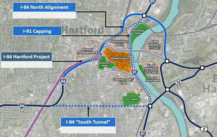
EDIT: ConnDOT diagrams:

C-6_cgJXoAEd6J3.jpg:large


The "South Tunnel" is U.S. Rep John Larson's acid fever dream of Big Digging his way straight underneath everything. It's patently insane, but he's stanning so hard for it it's actually impeding funding for replacing the damn falling-apart Viaduct with the EIS'ed Preferred Alt. because he wants them to waste money studying his MOAR TUNNEL short-attention span theatre beforehand. You can pretty clearly see what the North Alignment relocation does to heal the fragments of Downtown and East Hartford, as well as simplifying the everloving shit out of 91 and the interchanges. Important to note: because it is just outside the project area for the Viaduct replacement, it doesn't have to be considered in-tandem with the Viaduct. They can sink that into the cut as if it's going to keep feeding the downtown canyon forever, then work the North Alignment funding separately. No Viaduct replacement work ends up wasted if they have to switch gears with a later-breaking go-ahead for the North realignment.
 
Last edited:
ConnDOT's got a pretty meaty amount of info on its project page, BTW: http://i84hartford.com/

Honestly, one of the better web presences I've ever seen a state DOT put together.

-------

Charts-n'-stuff. . .

  • 3D Tour of the Viaduct replaced Preferred Alternative (highway in a cut): https://vtour.123bim.com/HTFX/vtour.html.
    • Note the major realignments of Capitol Ave. and Hawthorne St. into paralleling thoroughfares, with Hawthorne absorbing the access to deleted Exit 46 (Sisson Ave.).
    • Note the realignment along the Springfield Line. This is why trains have to vacate Union Station for a new 4-track + freight passing track bunker on the corner of Asylum Ave. & Spring St. Switch views to the "capped" versions and you can see a block-spanning headhouse along Asylum connecting the new train station to the old (continued use for intercity buses + CTransit/CTFastrak). And then obviously the much more massive redev cover-over of the Broad/Asylum block with Oak St. extended to Union Place as new street grid.

  • Elevation change for various Viaduct replacement options vs. street level. Alt 3 (the cut) is the Preferred Alt.
Alternatives_Vertical Alignment.jpg


Clearly the above pictures did not "jump start" a thread that just doesn't have much going for it. However, it doesn't have NOTHING going for it, so here's a bit I found.

First, there's a Hartford Development facebook page that you can browse, whether or not you actually have a facebook account.

The main project going on right now is the DoNo development, surrounding Dunkin Donuts Park. (looks like that's a baseball field for a minor league team)
https://www.hartfordbusiness.com/article/hartfords-250m-dono-development-nears-groundbreaking
 
Thanks for the effort nevertheless. The issue is that we don't really have an endemic Connecticut cohort of users to keep this forum active at daily levels. I suppose we could share in that Facebook page.
 
I'm going to be spending some extended time in this area, at least through the remaining worst parts of Covid. I had one eye on this category to see when it was finally going to get a new post. I'll be happy to contribute what I hear or see as I start to get more familiar with the area and its development coverage. Definitely I'm starting at a disadvantage because this is the place where I came to learn about Boston development! There's a lot to like about Hartford, but the difference is that it's not going to come to you, you have to really seek it out. My general impression is that the arts scene punches above its weight (or will again in the future), the infrastructure has a lot of potential and capacity (with that 84 project looming over everything of course), and that improvements to the urban fabric will be possible without forcing too steep of an increase in housing costs. At the very least, I will certainly plan to be one very strong voice in favor of the BOS-HFD-NYP Inland Regionals!
 

Op-ed co-penned by a Hartford City Councilor with some great, common sense reccomendations on the the importance of and how to revitalize the downtown. Much smaller scale stuff than ripping out the 84 scar but great to see an elected speaking up. Hartford has made some great steps in the past like eliminating parking minimums, but the prevalence of surface lots sticks out immediately. Lots of potential, and frankly the state should see the value in developing an attractive urban area to stem the 2 sided population drain CT has dealt with. Empty nesters don't want to pay the taxes with their kids out of the school systems and young professionals don't want to move home to "the state you drive though between New York and Boston"
 

Back
Top