High Speed Tolls

Also, nothing is more annoying than motorists being in the EZPass lane who are not EZPass members
I partly blame this on MassDOT. Their signs should just say:

EZPass
*Only*

That's clear enough: only EZ Pass offered, only EZ Pass accepted.
Instead they say:

EZ Pass Only
No Cash

I think "No Cash" confuses it. It becomes unclear whether the sign is about how you want to pay or what they're willing to accept.

These days, at all contexts except toll booths, "No Cash" is equivalent to "Use Debit/Credit Here"...because everybody else in the world is flexible about how you get them the money you owe. So I suspect that "No Cash" is giving people with literally no cash the false hope that they can do a
no-cash transaction using a card. Or a check. Or a token. Or tapping a stored-value card (Charlie Card). The "No Cash" world is a lot bigger than just EZ Pass.

The other part is that the EZ Pass lanes should look "more different" when you're up close--big signs overhead are useless once you're one car back.

Part of the solution from c 2000 to 2013 would have been be to have automated toll booths that actually take debit/credit cards (as I've seen on highways in Spain, with the old-school lifting gate, and as we all see at parking garage exits). And frankly, if they stay with booths, they might as well do this.

But at this point, the answer is, in fact, license-plate readers and send-them-a-bill, which is how the High Speed Tolls are going to work too. So now, people with "No Cash" on them will be able to go through with no cash.
 
Last edited:
How can it be in anyone's economic interest to spend so much time crawling on highways? Sorry, don't mean to derail the thread so I'll try to tie it in.

I think some people weigh the value of certain things differently than others. My parents have a beautiful waterfront home on the South Coast. The same property would likely have cost them double closer to the city. What they paid for the waterfront home a ways out of the city would get them an average home on a small lot in an inner suburb like Newton. My father loves fishing, his little boat, setting out crab pots, etc. he and my mother both commute 2 hours or so in each direction to work. He considers it to be worth it as his dollar goes further as the distance from downtown increases and his property suits his interests better. My mother likes where they live but admits she'd trade it for something smaller closer to the city "now that the kids are gone."

I prefer smaller and closer to the city (although my budget doesn't really give me many options at the moment), but I can see the draw of living further outside of the city. Some people get anxiety in/near the city for some reason. They'll work there, but "need" the (semi/faux) rural lifestyle outside of work. Sitting in traffic isn't what it used to be either. Cars are more comfortable now, smartphones make customizing music playlists easy, and even though it's frowned upon, checking Facebook/twitter/Instagram/snapchat/etc isn't hard in traffic.

Economically, people consider more "bang for their buck" to be worth the added distance and time. Boston's housing costs aren't going to be doing much to change that in the near future.
 
I partly blame this on MassDOT. Their signs should just say:

EZPass
*Only*

That's clear enough: only EZ Pass offered, only EZ Pass accepted.
Instead they say:

EZ Pass Only
No Cash

I think "No Cash" confuses it. It becomes unclear whether the sign is about how you want to pay or what they're willing to accept.

These days, at all contexts except toll booths, "No Cash" is equivalent to "Use Debit/Credit Here"...because everybody else in the world is flexible about how you get them the money you owe. So I suspect that "No Cash" is giving people with literally no cash the false hope that they can do a
no-cash transaction using a card. Or a check. Or a token. Or tapping a stored-value card (Charlie Card). The "No Cash" world is a lot bigger than just EZ Pass.

The other part is that the EZ Pass lanes should look "more different" when you're up close--big signs overhead are useless once you're one car back.

Part of the solution from c 2000 to 2013 would have been be to have automated toll booths that actually take debit/credit cards (as I've seen on highways in Spain, with the old-school lifting gate, and as we all see at parking garage exits). And frankly, if they stay with booths, they might as well do this.

But at this point, the answer is, in fact, license-plate readers and send-them-a-bill, which is how the High Speed Tolls are going to work too. So now, people with "No Cash" on them will be able to go through with no cash.


Yeah, it reads EZPass on the ground in the lanes for it.

The signage is clearly marked above, but stupos who are NOT EZ Pass members, tend to get in the EZPass lanes anyway. And then, they're trying to switch lanes, tying up and slowing down traffic behind them!! :mad:
 
Last edited:
Raytheon will start installing AET at (appropriately enough) Route 128 in April.

http://www.bizjournals.com/boston/b...t-awards-130m-electronic-toll-collection.html

I'm not sure what "conversion" means in this article. The term implies that once an interchange is converted it would be AET only, but maybe they just mean "installed." It's also possible that each interchange would see EZ PASS lanes removed from around the toll plazas while the cash lanes would stay open until the following summer.

In other news, adoption remains slow among the tin foil hat demographic.

http://www.boston.com/business/pers...2wScAL/story.html?p1=Topofpage:sub_headline_1

I wonder if the people concerned about the "good jobs that toll takers have held for decades" would have opposed telephone numbers because they took good jobs from operators.
 
Are there any plans to redevelop the Weston interchange following the implementation of open road tolling? The mess of ramps makes the Allston offramps seem simple and well coordinated. I did a quick search but couldn't find anything noted.
 
Are there any plans to redevelop the Weston interchange following the implementation of open road tolling? The mess of ramps makes the Allston offramps seem simple and well coordinated. I did a quick search but couldn't find anything noted.

I know it's on the radar screen, but I think we're looking at 2030 or later. They'll do Allston, Canton, Reading, and perhaps even a full rebuild in Burlington first. That's not even counting the stuff in Springfield.

I suspect MassDOT isn't thrilled to think about Weston. The river makes things tricky, especially since 128 might need to be realigned on the immediate shoreline. For the time being, they'll probably rip out all of that wide pavement at the toll plazas, but the double-bow set-up will probably stick around until the river viaducts are too far gone to ignore.

The good news is that Weston is probably the second major rebuild on the Pike corridor after Allston, and they have a dedicated funding source for it from toll revenue, so it should happen at some point.
 
I suspect the river viaducts are already too far gone to ignore. But it might take a flunked bridge inspection, a lot of press coverage, $10M in interim repairs, and a mad scramble for them to get on it.

It's scary enough to look at driving under on 128. Can't imagine what it looks like from a canoe.

MassDOT inspects every bridge in the State on a 2-year cycle, and "flunking" one is actually kind of nuanced. Without a doubt those structures have flunked in the sense of being found to be structurally deficient, but all that does is get it on the radar screen and ramp up the frequency of inspections.

IIRC there's money in the CIP to preserve those bridges in the 2018-2020 time frame. Actually, as long as it's not a safety issue, I'd rather wait for the funding to be there to redo the interchange completely before replacing them. The speed and suddenness of the Allston project has made me somewhat optimistic that big projects on the Turnpike can be funded relatively straightforwardly when the bridges become critical.
 
Now that the electronic tolling "overhead readers" have been installed all over the pike it got me thinking of a few things that I have no been able to find answers to. Being from Framingham-using my hometown as an example here- if you leave here it can take like 20 minutes to get to the Boston city limits under perfect traffic conditions and driving at a "masspike pace". The thing is this place at certain times of the day will have some of the worst traffic you will ever see anywhere in the state including Boston. You might as well paint a parking space around you car on route 9 if you are on it at 5pm on a week day.

This got me thinking. Obviously the electronic readers are going to make the on ramps to the pike less congested (I hope). The thing is for this being the biggest town in America we only have 2 access points to the pike. And they are spread out at both ends of the town and it takes 30 minutes to get across town anyways. Thats in my opinion a bigger reason for so much traffic being concentrated in certain areas than the toll booths themselves although those contribute a lot. The fact that there are only 2 on ramps for a town of 70+ thousand people is crazy. So after reading through this pdf on essentially the plan for the whole thing http://www.massdotinnovation.com/Pdfs/Session1D-AllElectronicTolling.pdf it doesn't mention anywhere about fixing the on and off ramps or about the possibility of adding more.

Some of the huge possibilities that come from this style of overhead tolling is that:

1. You can get rid of the snaking roads that were needed to offset the toll booths away from the highway giving room for traffic behind them and also diverting the people to which direction they need to go after they pay. Once the booths are gone I would imagine that they will get rid of these roads and just built simple on off ramps like you would see on 495,290,146 really any other highway. I really hope this is in the plans because just knocking down the booths and keeping these roads will be a mess. Framingham is generally pretty straight forward but in areas like the Hopkinton on off ramps for the pike it is a disaster, and thats when you can only drive 5 miles per hour. Imagine the Hopkinton ramps at uninterrupted masshole on ramp speeds.

2. With this system you can essentially add an on off ramp section anywhere along the pike you want. Im sure plenty of you know of many places where you have to literally drive under or alongside the pike on your way to get to the on ramp. In my example I live probably 1 minute and 30 seconds from the mass pike, but to get to one of the on ramps can take from 10 minutes to an hour. I hope the state is researching this to see where the best locations will be to add new ramps after they (hopefully) knock down the old booths and realign the already in place ramps. Obviously you don't want to throw on too many on or off ramps and not just put em everywhere one highway/road passes the pike, but there are plenty of spots all over the state they could be added. I feel like commuting times, congestion, pollution, quality of life, access to resources...etc. will be greatly enhanced if these two things happen. It would basically make the state smaller allowing people living further from the city easy access to get in. It could also allow people who work in the city the benefit of being able to afford a home in an area that is much less expensive while still having a reasonable commute into the city.
 
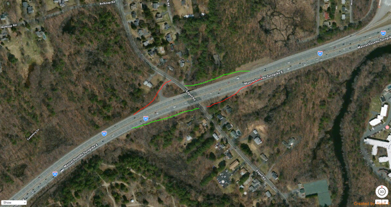
As I said above the Framingham on off ramps can basically just have the toll booths knocked down and it will be pretty much a straight shot. The main problem here is the limited access points. I looked at a few spots like central street and rt 30 but I don't think there was room so as an example I used Edgell rd. In this situation there are already two access points for emergency vehicles so they could just be paved and lengthened a bit and call it a day. Then just add two off ramps and theres a brand new access point to the pike. The part in the upper right corner is a service plaza not the fram/natick on ramps. This isn't the end all be all example, I'm just demonstrating the possibilities the new electronic tolling system creates for the entire state.


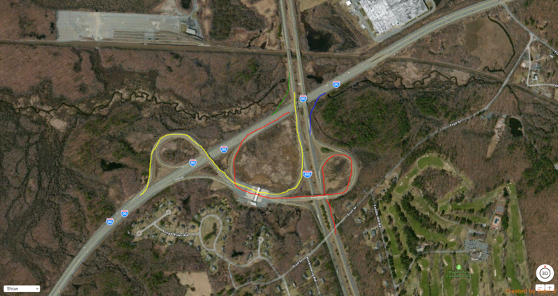
I dont have a ton of time so I combined this but in the Hopkinton example you can see in red the path needed to go from 495 north to 90 east. In yellow you can see the opposite. I made the new 495n-90e on ramp in blue and the opposite in green. The problem with this area is all of the ramps combine and collide at one point and then you have people in the left lane for example who need to go east on the pike cut off all lanes of traffic blocking those drivers along with screwing the people trying to head towards worcester. This is an example where restructuring the ramps would greatly improve traffic flow and congestion.

Again this is no professional traffic study and I didn't even include all of the ramps Im just demonstrating the concept of what is possible here.
 
The one I'm really looking forward to is 290N to 90E. You actually have to travel half a mile on a local road (Route 12) to make the connection!

Other spots that stand out as some really obvious new/improved interchanges:
*Oak Street or Route 27, Natick
*Edgell Road, Framingham
*Cordaville Road, Southborough
*Route 135, Hopkington
*Route 122, Grafton
*A less stupid interchange with Route 20 and Route 146, Millbury. Perhaps move the 20 interchange a mile west and have that just be a 146 interchange.
*Route 56, North Oxford
*Stafford Street, Charlton
*Route 19 and/or 67, West Brookfield and Palmer
*Route 20, Palmer
*Fix the I-291 interchange, Chicopee
*I-391 and Route 16, Chicopee
*Fix the I-91/Route 5 interchange, West Springfield
*Route 23 and 20, Russell
*Somewhere in Becket
*Route 7, Stockbridge
*Complete the half-exit at Route 41 and 102, West Stockbridge

That's a fairly lengthy list, and those east of 84 probably need to be combined with enhanced bus and rail service to avoid overcrowding the Pike any worse. But that's about what you'd expect if this had been constructed as an up-to-standard highway in the first place, instead of a poorly thought out turnpike.
 
I dont have a ton of time so I combined this but in the Hopkinton example you can see in red the path needed to go from 495 north to 90 east. In yellow you can see the opposite. I made the new 495n-90e on ramp in blue and the opposite in green. The problem with this area is all of the ramps combine and collide at one point and then you have people in the left lane for example who need to go east on the pike cut off all lanes of traffic blocking those drivers along with screwing the people trying to head towards worcester. This is an example where restructuring the ramps would greatly improve traffic flow and congestion.

MassDOT recently awarded a design contract for 495-90.

http://www.495partnership.org/asset...ession presentation 3 17 2015 rw comments.pdf

Interesting info in the traffic numbers in there. Almost 8000 cars an hour using the ramps in the morning. No wonder it's so slammed.
 
Thank you, I knew someone would know something about this. Now does anyone know if there are any plans yet to actually add on/off ramps in places where they did not exist previously but are needed and possible due to no longer needing toll booths?
 
Thank you, I knew someone would know something about this. Now does anyone know if there are any plans yet to actually add on/off ramps in places where they did not exist previously but are needed and possible due to no longer needing toll booths?

Quick answer: No. MassDOT's CIP doesn't include any before 2021.
 
Thank you, I knew someone would know something about this. Now does anyone know if there are any plans yet to actually add on/off ramps in places where they did not exist previously but are needed and possible due to no longer needing toll booths?

Nothing on the table today, but it's been talked about for Western MA for over 20 years in Berkshire and Hampden counties. Albeit in the context of the whole free-tolls balancing act that existed out there for those residents. They were considering these two primarily, which are both badly needed:

-- US 20/MA 8, Becket. Plugs a gap where nearly the whole of SW Hampden County and northern Litchfield County, CT are shut out by lack of access to/from Route 8.

-- US 20, Russell. Congestion mitigation for downtown Westfield which gets slammed by volumes from the US 202 exit that are simply heading west in the same direction as the Pike. New exit would be right down the street from Westfield State U., and provide access to MA 112 heading north and 20/MA 25 heading west into Blandford.


This one was also considered as an third possibility, but was pegged a lot lower in priority than Becket and Russell.

-- US 7, Stockbridge. Not too far from the existing Lee and West Stockbridge exits, but Route 7 is the biggest load-bearing road in the county and US 20/MA 102 @ Lee is clunky wayfinding for reaching Great Barrington, Sheffield, and Egremont.


^^All of those were real proposals in somewhat recent history that never advanced anywhere because of the toll conversation.
 
-- US 20/MA 8, Becket. ...
-- US 20, Russell. ...
-- US 7, Stockbridge. ...
^^All of those were real proposals in somewhat recent history that never advanced anywhere because of the toll conversation.

Sounds great for mobility and network-balancing. How about we build those interchanges and pay for their cost with tolls?
 
Are they making/leaving provisions for developing/acessing the "infield" area, or is it just going to be a stranded median meadow when this is done?

Looks like it will be accessible from Park Rd, but given all the potential future needs to reconfigure ramps or shift the roads to facilitate maintenance I hope they leave it open to give DoT some flexibility.
 
Anyone willing to give a guess on the market value of the infield land? Ballpark? It's big enough for a legacy place or a westwood station....
 

Back
Top