I-695, Soutwst X-Way, Mystic Valley Prkway, S. End Bypass

If this had been built, it's highly likely that the big dig would have entailed tearing down the central artery and simply replacing it with a boulevard a good 15 years sooner than it happened in real life. There still would have been functional highways reaching downtown, but they simply would have ended at the location of the tunnel reaching the surface and the current location of the Zakim bridge.

Then the big dig would have buried the inner belt, leaving the area as a whole with much better transportation access-- it wouldn't take me 45 minutes to get from cleveland circle to Tufts on a saturday afternoon

The idea of burying the already aging CA was indeed present in a lot of the plans for the highway improvements I looked through.
 
The idea of burying the already aging CA was indeed present in a lot of the plans for the highway improvements I looked through.

True-- but given how high the costs would have been if all the proposed projects were built, it's hard to believe that the big dig would have been nearly as big for financial reasons.
 
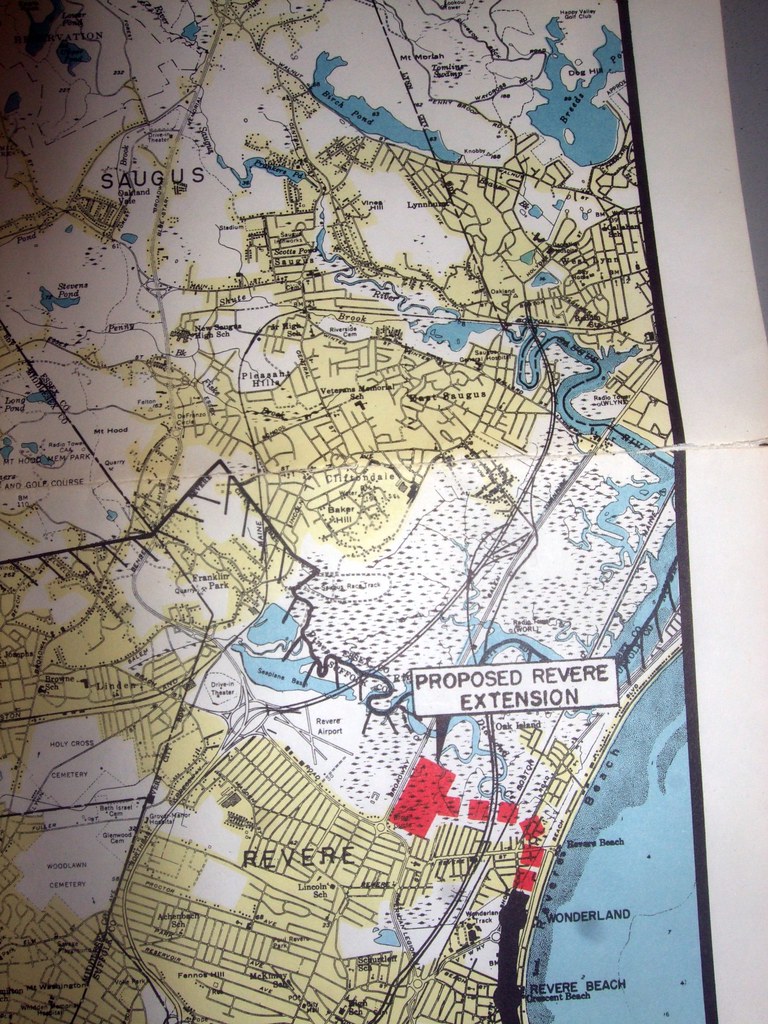
Can someone identify this mysterious proposed highway cutting through Revere?

6386990839_78ca0eb9ec_b.jpg


It seems to parallel 107 to some extent, so perhaps it was a proposed upgrading of 107 into Chelsea.
 
That might be the East Boston Expressway, an auxiliary route for the proposed Northeast Expressway (I-95). It could also be the actual Northeast Expressway.

I have diagrams of all these from the morning that I spent at the Transportation Library (probably one of the coolest mornings ever). I have to scan them all in though.
 
Re: Movie about water resonance frequency to capture hydrogen + oxygen molecules

As long as we're talking oil...

Why hasn't anyone yet tried to produce synthetic/artificial oil? Relying on a supply of something we need to pull from the ground until it's gone seems like a bad idea in general.

Why can't we figure out how to make fake oil?

There was a movie about ten years ago. I can't think of the name of it though. This movie had scientists who figured out you could take water, put it at a tank and use an underwater speaker omitting a certain tone that was tuned to the correct level of resonance frequency to split the molecules of hydrogen and oxygen. Each element would then be collected separately. The hydrogen would be flammable (using the oxygen to burn.) But there was a problem the major energy companies didn't want this secret to get out because all of the countries of the world could buy this system and use sea water to produce their own electricity cheaply. So these scientists were hunted down because their invention was too powerful and should never be allowed to see the light of day.
 
Can someone identify this mysterious proposed highway cutting through Revere?

6386990839_78ca0eb9ec_b.jpg


It seems to parallel 107 to some extent, so perhaps it was a proposed upgrading of 107 into Chelsea.

I believe it was an extension of the East Boston expressway-- yet another project that had it given north shore communities improved highway access, may have prevented such large declines.

There was a movie about ten years ago. I can't think of the name of it though. This movie had scientists who figured out you could take water, put it at a tank and use an underwater speaker omitting a certain tone that was tuned to the correct level of resonance frequency to split the molecules of hydrogen and oxygen. Each element would then be collected separately. The hydrogen would be flammable (using the oxygen to burn.) But there was a problem the major energy companies didn't want this secret to get out because all of the countries of the world could buy this system and use sea water to produce their own electricity cheaply. So these scientists were hunted down because their invention was too powerful and should never be allowed to see the light of day.

Is this a joke?
 
improved highway access, may have prevented such large declines.

Yeah, because Salem's stellar highway access is why it's so popular these days.

Assuming the "large decline" means Lynn, let's just ignore the fact that it's perhaps rampant with corruption, was ravaged by great conflagrations, and never found a new industry after the loss of its shoe industry.
 
The large marsh that is along Route 107 between Revere, Saugus and Lynn would have been destroyed by the three proposed expresssways bisecting it in the map. Interstate 95 and the East Boston X-way extension both would have sliced it north to south, and the Revere Connector would have sliced it east to west. Add the interchanges needed between the three expressways, and all that would have been left of the swamp would be isolated pockets full of fetid water, trash and probably gradually filled in for strip malls and warehouses.
 
The large marsh that is along Route 107 between Revere, Saugus and Lynn would have been destroyed by the three proposed expresssways bisecting it in the map. Interstate 95 and the East Boston X-way extension both would have sliced it north to south, and the Revere Connector would have sliced it east to west. Add the interchanges needed between the three expressways, and all that would have been left of the swamp would be isolated pockets full of fetid water, trash and probably gradually filled in for strip malls and warehouses.

It's already bisected three times by a rail line, 107, and the fill for I-95. The rest could be accomplished with minimal additional fill beyond what is already there.

Yeah, because Salem's stellar highway access is why it's so popular these days.

Assuming the "large decline" means Lynn, let's just ignore the fact that it's perhaps rampant with corruption, was ravaged by great conflagrations, and never found a new industry after the loss of its shoe industry.

I know a number of people that live in that area and it takes them a long time to get out of the north shore in the morning. Mass transit doesn't bring them to the jobs they have, so they end up spending a ton of time commuting.
 
It's already bisected three times by a rail line, 107, and the fill for I-95. The rest could be accomplished with minimal additional fill beyond what is already there.

The blue shape is the existing fill placed for the cancelled I-95 Expressway.

The red areas would be additional fill that would be needed to build the Revere Connector and the East Boston Expressway extension. These fill areas are pretty substantial.

There would need to be numerous breaches in the fill spanned by bridges for all three expressways to allow circulation of water between the isolated pieces of marsh that would remain.

rumneymarsh.jpg

Why not use 107 to connect the two?

You're exaggerating the footprint of the highway-- the road bed in place is wide enough for the proposed I-95
 
It's not the road bed but the embankment that would do the most damage. Look at that area in satellite and you'll see how accurate his estimations are.
 
Is this a joke?

referring to

[/quote]
There was a movie about ten years ago. I can't think of the name of it though. This movie had scientists who figured out you could take water, put it at a tank and use an underwater speaker omitting a certain tone that was tuned to the correct level of resonance frequency to split the molecules of hydrogen and oxygen. Each element would then be collected separately. The hydrogen would be flammable (using the oxygen to burn.) But there was a problem the major energy companies didn't want this secret to get out because all of the countries of the world could buy this system and use sea water to produce their own electricity cheaply. So these scientists were hunted down because their invention was too powerful and should never be allowed to see the light of day.

[/quote]

Kaht -- are you serious?

Of course its either a joke or fiction -- though not science fiction

water is water because of the binding energy linking the 2 Hydrogens to the Oxygen -- breaking those bonds requires the same amount of energy as you get when you make the bonds -- that's why the Hydrogen economy is a myth which is busted

the only way you can make a hydrogen economy is to make like a leaf -- use the energy from the sunlight to break the H-O bonds and get yourself some chemical energy in the form of H2 or more like a plant as sugar

So far we haven't gotten anything in the way of an effecient H2 direct from sunlight process -- the best that's been done is using algae to capture the solar energy and then use the algae to make a feed-stock for diesel fuel
 
water is water because of the binding energy linking the 2 Hydrogens to the Oxygen -- breaking those bonds requires the same amount of energy as you get when you make the bonds

Dam, I'm never gonna drink that crap again.
 
This month's ArchitectureBoston is all about these projects.

The Roads Not Taken
How one powerful choice made all the difference.

roads-not-taken-lrg.jpg


http://www.architects.org/architectureboston/articles/roads-not-taken

Lots of great images and info.


On the Wrong Side of a Right-Of-Way
Excerpt by Alan Lupo / Winter - 2012: Turn Signal (Volume 15 n4)

Winter12-NotTaken-large.jpg


http://www.architects.org/architectureboston/articles/wrong-side-right-way


Ripple Effects
By Alan Altshuler, Anthony Flint, Ann Hershfang, Fred Salvucci, David Lee FAIA , and Ken Kruckemeyer AIA / Winter - 2012: Turn Signal (Volume 15 n4)

ripple-effects-lrg.jpg


Few policy decisions have had as much effect on placemaking as the transportation rethink of the early 1970s in Boston. But the highway moratorium’s influence is still being felt far beyond Route 128. We asked six planners, designers, and activists to trace the echoes.

http://www.architects.org/architectureboston/articles/ripple-effects
 
I'm struggling to recognize the location of the first photo. The accompanying article says Lamartine Street, but is it really?
 
I'm struggling to recognize the location of the first photo. The accompanying article says Lamartine Street, but is it really?

No it isn't. That's looking north from Lower Roxbury, probably just above Washington St at Ramsay Park. The Northeastern campus is on the upper right, the large white building is on the even side of Tremont St between Hammond St and Melnea Cass Blvd. Melnea Cass would probably take up much of the park in the foreground (Madison Square maybe?).
 
Is that the Washington Street El running left-to-right about 1/3 of the way down the photo? What is the modern white landscraper building just below it, on the right?
 
I can't help but wonder if city life would have been better if the Pike went via 695's proposed routing to Melnea Cass ROW and then 93. Whittle down the B&A railroad to 2 tracks + 2 track spaces for heavy rail, and it would have been much, much easier to deck over do to slim width -- like it wouldn't even phase people's minds at all. The Pike through Ruggles and Roxbury and also be easier to deck over, as it would have been without tracks alongside. The spaghetti bowl interchange with 93 would have not overwhelmed the Leather District, but rather could have been on top of the Southampton train yards and train loop.

But alas, my preferred option would still be superior to all others: no build.
 

Back
Top