I-90 Interchange Improvement Project & West Station | Allston

Beacon Yards Masterplan | Allston

Im not sure if there is already a thread for this. I looked but could not find anything on the actual masterplan beyond the mass pike realignment. Here are a few renderings of what could be coming to Allston after the Mass Pike realignment. There are two different Master Plans posted. The first one moves Storrow Drive to create an Allston Esplanade. The second one creates an extension of the Charles River. I have included links which contain a more in depth look and more renderings. I can only imagine how drastically different it would be coming through this on the masspike/commuter rail versus what there is now. This would be a brand new gateway to the city.
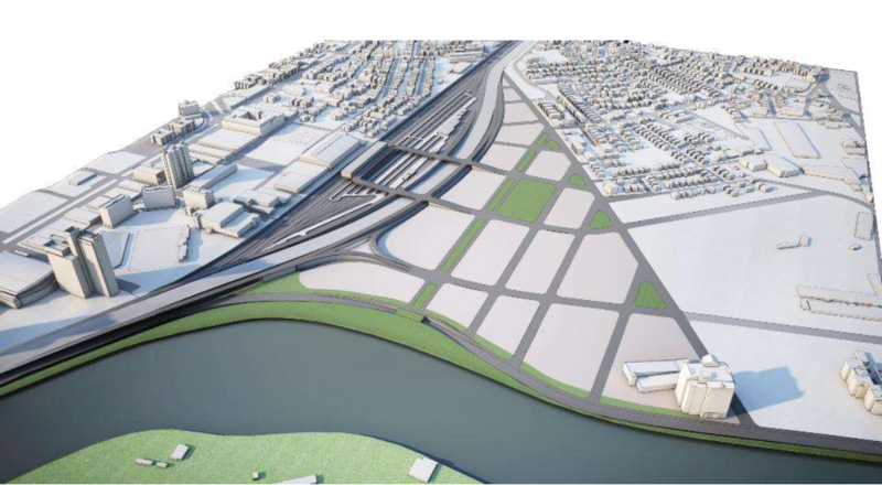


2014-10-Allston-Esplanade-CAMERA_1_-Aerial_10-2-2014.jpg


Alternate concept

Beacon_Yards_Northeastern.jpg


Storm%20Water_Rowan_1.jpg


http://www.architects.org/sites/default/files/images/email/BSA_Beacon%20Yards%20Urban%20Design%20Workshop_KRIEGER-MOUNTJOY%20team.pdf

http://www.bostonglobe.com/opinion/editorials/2015/05/07/dante-ramos-beacon-yards-here-comes-neighborhood/UawILR3d1D3xPvOYlO5SkJ/story.html?p1=Article_Related_Box_Article

http://www.utiledesign.com/news/proposed-beacon-yards-by-northeastern-graduate-studio/
 
Last edited:
Re: Beacon Yards Masterplan

On the realignment, I've always wondered why they don't bring I-90 even closer to the tracks. I know they want to leave room for West Station, but is it really worth wasting all that potential space. I'd rather see them deck over the rail.
 
Re: Beacon Yards Masterplan

On the realignment, I've always wondered why they don't bring I-90 even closer to the tracks. I know they want to leave room for West Station, but is it really worth wasting all that potential space. I'd rather see them deck over the rail.

I've thought that too. West Station doesn't *need* space either. Could have been entirely underneath the Pike viaduct... same goes for any train yards they wanted to maintain for MBCR.
 
Re: Beacon Yards Masterplan

I love the daylighting of Salt Creek in Utile's proposal.
 
Re: Beacon Yards Masterplan

Im pretty sure its going to be used for storing/maintenance of commuter rail trains and then eventually DMU's to take some load away from the other areas.
 
Re: Beacon Yards Masterplan

Damn. That's sexy.

Ofsevit has has an interesting run of pieces on his blog about bringing the Pike Ext down to grade and elevating the GJ out of West Station. He's put in the grunt work on spec-ing it out, so I'm not going to piggyback off the work: can be found on Amateur Planner.

I'm liking the alternative concept, (fifth pic), with a row of buildings securing Salt Creek from the new alignment and the buildout directly abutting West Station.

(Not to rustle any feathers here - and to go wildly off-topic - but I still think "West Station" is the best name for the sub-neighborhood. For the station itself, maybe West Station - Allston/Allston-West Station/some variation on that. If MassDOT and the MBTA play their cards right, they can create a modal hub there with the 66, some variation of GJ LRV/DMU service, Worcester Line, and Worcester Line-Riverside DMU. West Station would fit in well with the other major hubs of North and South. I'd certainly take boring old "West" over some kitschy, non-descriptive "Allston Landing, Gare du Rat City, Niederallston Hauptbahnhof")
 
Re: Beacon Yards Masterplan

Here's a few more pics, ripped from DeNovo:

eSVXBE0.png


arURcdE.png


GEyhbdq.png


PcNyTdN.png


I'd say, if we're going crazy here - just fuck and do a bunch of canals (not serious, fwiw) - we'll underwater anyways before Harvard ramps up construction on their plots.
 
Re: Beacon Yards Masterplan

Why is it "Salt Creek" and not "Salt Brook"?
 
Re: Beacon Yards Masterplan

Probably a zero percent chance the elegant version will be done in Boston. My guess is the pike will be relocated streets will be paved on the left over land and then seaport esque architecture will fill in behind it. If it does happen it would be incredible if on the sides of the building facing the channel there were outdoor patios lines with restaurants and coffee shops.
 
Re: Beacon Yards Masterplan

Why is it "Salt Creek" and not "Salt Brook"?

Same question. It would appear to be a historical quirk, considering:

dwatkins_usstreamnames.png


To make things even more...odd, I found this quote from a 1903 "Report of the Committee on Charles River Dam: Appointed Under Resolves of Chapter 105, to Consider the Advisability and Feasibility of Building a Dam Across the Charles River at Or Near Craigie Bridge":

"There are also numerous smaller brooks, such as the Salt Creek Brook (?), the Shepherd Valley Brook, and the Faneuil Valley Brook..."

Elsewhere the report refers to it as just "Salt Creek", while it refers to other brooks in Brighton as Shepherd Valley Brook, South Valley Brook, etc... So.......
 
Re: Beacon Yards Masterplan

Salt creek used to be in that spot before it was filled in.
 
Re: Beacon Yards Masterplan

Salt creek used to be in that spot before it was filled in.

Right, but why was it a creek? Brook is pretty uniform to describe streams/tributaries around here, including all the other non-longer extant streams in Brighton.

Anyways...that masterplan tho
 
Re: Beacon Yards Masterplan

I'd be happy if they just built the pictured bridges using the rendered designs. It's become more and more rare these days that people build elegant bridges.
 
Re: Beacon Yards Masterplan

Those were two solutions to a sketch problem put on by the BSA. They presented them before one of the pike meetings to show the potential of the site, but nothing's official.
 
I merged the two threads; we only need one until there is an actual plan and dirt is being moved.
 
Re: Beacon Yards Masterplan

I've thought that too. West Station doesn't *need* space either. Could have been entirely underneath the Pike viaduct... same goes for any train yards they wanted to maintain for MBCR.

They certainly could build West Station on a deck over the tracks/highway in order to enable them to close the gap between the tracks and the proposed realignment even further. I think I count 14 tracks and then just a few beyond that.

Or a deck over the tracks and highway with a surface road connection (or two) like some of the renders show. With the cost of the decking being made up if they can create more developable space from further straightening of the Pike.
 
The next public meeting of the MassDOT Task Force will be 6PM on Thursday, October 15th. As per the usual, we will meet in the community room of the Charlesivew Fiorentino Center at 123 Antwerp Street just off Western Avenue.

This meeting will be in a more interactive, charrette style to discuss the concepts presented at the last meeting to replace the elevated highway viaduct with an at-grade roadway.

Presentations from last meeting:
http://abettercity.org/docs/9.22.2015 ABC Allston I-90 At Grade.pdf
http://ariofsevit.com/17Sep15_comp3.pptx
 
Any word on when this should begin / whether or not they will be expanding to create that "Allston Esplanade" along Soldiers Field Road?
 
The Allston Esplanade is still strongly supported by a wide coalition of groups and individuals. Right now the primary focus is on the viaduct area, and after that is resolved the Allston Esplanade will move up on the list.
esplanade_with_trees.jpg
 
Cool. And yes there especially should be a new charles crossing here. And though I'm a well known auto-skeptic, I do think it should probably include a road bridge.
 

Back
Top