MBTA Buses & Infrastructure

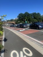
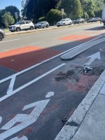
Bus lane expansions in Somerville and Brookline.

Hopefully they are not as useless (in terms of being utterly non-functional as actual bus lanes) as the pseudo-bus lanes on North Washington St. near Haymarket, or those in Allston-Brighton.


Does anyone have any insight into why enforcement of those pseudo-lanes is so terrible?

And whose job is it, anyway? BTD or BPD?
 
Does anyone have any insight into why enforcement of those pseudo-lanes is so terrible?

And whose job is it, anyway? BTD or BPD?

The general answer is that it depends on the roadway jurisdiction, whether that is municipal (Boston or Cambridge or Brookline, etc.) or state agency (DCR parkway, MassDOT highway, etc.). Even among municipalities, the enforcement entity can vary depending on the situation (in Boston, if it's a standing violation in an area with BTD Parking enforcement agents monitor, BTD Parking could ticket; if it's a moving violation, it largely falls to BPD). To make things even more complicated, MGL outlines prescriptive conditions for how parking violations can be carried out in specifically Cambridge and Boston (which is why cities like Somerville are trying out camera-based enforcement but Cambridge and Boston are not). To make things even more complicated (because why not!), MBTA Transit Police have a very broad jurisdiction across the service area. Depending on the route or the corridor (thinking of corridors like the 66 that cross through three municipalities, state roadways, etc.), there could be between one and several jurisdictional entities that are responsible for enforcement.

TLDR - it's complicated because of how we organize jurisdictional boundaries at a local level and define police powers at a state level. And based on how other systems have rolled out camera-based enforcement and have seen measurable successes, the best solution would be a state law that makes it easy to administer a similar program for everything from bus lane enforcement, red light cameras, bus stop blockage, etc. on a regional or state level.
 
The bus lanes listed above in Somerville already exist and bus jump queue lights at Inner Belt have been there for years - am I missing something here?

Current config (myrtle far left, crescent far right):
Screenshot 2024-06-20 at 23.43.34.png
 
TLDR - it's complicated because of how we organize jurisdictional boundaries at a local level and define police powers at a state level. And based on how other systems have rolled out camera-based enforcement and have seen measurable successes, the best solution would be a state law that makes it easy to administer a similar program for everything from bus lane enforcement, red light cameras, bus stop blockage, etc. on a regional or state level.
FWIW, there is currently a bill in the Senate, S.2600 that would do that. Ignore the title, the meat of the bill deals with transit buses. It reported favorably out of Transportation, but it's now in the morrass that is Senate Ways and Means, so write your state senator!
 
The bus lanes listed above in Somerville already exist and bus jump queue lights at Inner Belt have been there for years - am I missing something here?

Current config (myrtle far left, crescent far right):
View attachment 51829
They’ve been there but they were never painted red, so I guess they’re announcing they finally found some red paint?
 
Friend of mine reported on a mishap with the trackless trolley overhead near Harvard Square this morning:
OMG yall, so I'm waiting to cross mass ave at the common (cambridge), and this huge semi rig pulls out of that little cross street that cuts over from Garden, and it totally Storrows the overhead lines from the old electric buses, yanks a bunch of them off the poles and a couple of them snap and start swinging like giant pendulums of death.
🙀
The MBTA truck that's often parked there had someone in it that jumped out to stop traffic and report the problem, but holy cow.
That would have been even more dramatic if the overhead was still live.
 

MBTA gets $22 million in federal funds for Everett bus improvements

More than $22 million in federal money is on the way for MBTA bus improvements in Boston and Everett, an area that state lawmakers and developers are eyeing for a potential soccer stadium that would rely heavily on expanded public transportation infrastructure.

An MBTA project was awarded a $22.4 million grant through the federal Bipartisan Infrastructure Law to make "essential improvements" to bus service along the Lower Broadway and Alford Street corridor in Everett and Boston, U.S. Sen. Ed Markey's office announced Tuesday. The funding will cover bus-only lanes, priority signaling for buses and new stop facilities, Markey's office said.
 
I've updated my map of MBTA bus lanes:


Any corrections welcome! I'm not currently living in Boston, so I'm not always sure exactly what's on the ground and when it was put there.
Missing the lanes in East Somerville on Broadway from McGrath to Minnesota Ave, just added last year.
 
I've updated my map of MBTA bus lanes:


Any corrections welcome! I'm not currently living in Boston, so I'm not always sure exactly what's on the ground and when it was put there.
Bus lanes on this portion of Maffa Way was REMOVED in favor of a second lane for cars during construction, meaning bus headways have been sent to die in Sullivan Square traffic for the next 2 years. :eek:

Can't they just stuff all the cars into merging into a single lane, and keep the bus lanes, to ensure bus riders are accommodated during construction? The bus shuttles for the last OL diversion has been an utter disaster.

1719800488639.png
 
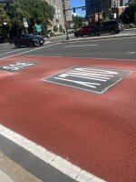
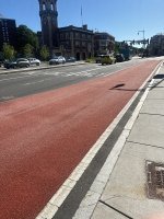
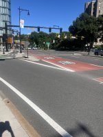
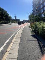
New bus lanes on Route 9 in Brookline. Most drivers seem to be on top of it even without the signage that has yet to be installed.
 

Attachments

  • IMG_1301.jpeg
    IMG_1301.jpeg
    3.3 MB · Views: 69
  • IMG_1298.jpeg
    IMG_1298.jpeg
    3.8 MB · Views: 65
  • IMG_1295.jpeg
    IMG_1295.jpeg
    2.6 MB · Views: 77
  • IMG_1294.jpeg
    IMG_1294.jpeg
    3.3 MB · Views: 69
  • IMG_1292.jpeg
    IMG_1292.jpeg
    2.5 MB · Views: 71
  • IMG_1277.jpeg
    IMG_1277.jpeg
    2.7 MB · Views: 73
5_20_Transitways_Separated Busway.jpg


Looking at this render provided by the MBTA for the new Everett Lower Broadway Bus Lanes... I have questions. Firstly, no where along the Alford-Sweetser Circle segment looks like that, from an urban environment perspective. Rather, it looks much more like Broadway north of Sweetser. Secondly, there isn't a hint of a separated bike lane in that render; It may be an illustrative render of "hybrid center-running bus lanes," but it isn't exactly a good representation of what this will look like.
 
Dunno, that looks like an attractive urban street to me. That MBTA has figured out separated BRT is a miracle and something we can brag about to other cities. As a cyclist I'm OK with not having a bike lane here -- the next step would be to make cars a guest on the corridor and have bikes/peds/outdoor dining on the other half.
 
View attachment 52291

Looking at this render provided by the MBTA for the new Everett Lower Broadway Bus Lanes... I have questions. Firstly, no where along the Alford-Sweetser Circle segment looks like that, from an urban environment perspective. Rather, it looks much more like Broadway north of Sweetser. Secondly, there isn't a hint of a separated bike lane in that render; It may be an illustrative render of "hybrid center-running bus lanes," but it isn't exactly a good representation of what this will look like.
I wouldn't read too much into this graphic as a complete representation of this specific project. The rendering matches their separated bus lane graphic from the MBTA's BRT toolkit (page 25/77), which MBTA released last year. They probably didn't have a rendering or good illustration for this project already, so I'm guessing someone in their press office wanted to include a rendering and this visual was the best they had on short notice.
 
I wouldn't read too much into this graphic as a complete representation of this specific project. The rendering matches their separated bus lane graphic from the MBTA's BRT toolkit (page 25/77), which MBTA released last year. They probably didn't have a rendering or good illustration for this project already, so I'm guessing someone in their press office wanted to include a rendering and this visual was the best they had on short notice.
Indeed it is cribbed from that doc; that definitely solidifies it as just being representative of the type.
 
I wouldn't read too much into this graphic as a complete representation of this specific project. The rendering matches their separated bus lane graphic from the MBTA's BRT toolkit (page 25/77), which MBTA released last year. They probably didn't have a rendering or good illustration for this project already, so I'm guessing someone in their press office wanted to include a rendering and this visual was the best they had on short notice.
In addition to this, I personally think Lower Broadway is very unlikely to be trimmed down to 2 travel lanes from 4 in order to accommodate the dedicated busway (which, to be clear, I'm still very stoked about). I can write an essay on this -- and I probably have done so in March -- but in short, a 2+2 setup wouldn't have to move bike lanes to private property, which was explicitly called for in the SLX Alternatives Analysis.
 
These are the images Mass Streetsblog took from the USDOT RAISE grant application in its recent article about the award.

IMG_0282.jpeg

IMG_0281.jpeg

I can’t imagine either them going down to two lanes total (one in each direction) given the current volumes let alone expected increase in road demand once things really get built out in that area. This is also a heavy trucking route so that’s another factor to consider under a road diet scenario.
 
These are the images Mass Streetsblog took from the USDOT RAISE grant application in its recent article about the award.

View attachment 52309
View attachment 52310
I can’t imagine either them going down to two lanes total (one in each direction) given the current volumes let alone expected increase in road demand once things really get built out in that area. This is also a heavy trucking route so that’s another factor to consider under a road diet scenario.
Wow, I'm impressed they actually cut it down to 3 lanes over the Alford St Bridge. I know the bridge is probably not wide enough for 4 travel lanes and everything else, but this means they did push through at least one section of lane reductions.
 

Back
Top