MBTA "Transformation" (Green Line, Red Line, & Orange Line Transformation Projects)

As long as it's light rail, I think Central Avenue and Milton stay separate. As seen above, Central Avenue actually outslugs Milton on ridership (I'm not quite sure why), and something like 50-100 riders a day transfer from the 240 there (see 2019 profile). Merging them seems like it would inconvenience passengers, while only saving the relatively small cost of rebuilding Central Avenue.

If it's ever converted to a Red Line extension, then merging makes sense given the higher per-station cost. The longer station would reduce some of the walking distance, and it would be worth rerouting/terminating bus routes there.
 
Last edited:
There's going to have to be a hard look at Capen Street, Valley Road, Butler, and Cedar Grove. They collectively account for 178 daily boardings (4.6% of ridership), yet are estimated to account for $45M in renovations. Even if that number is massively slashed (as it should be), you're still looking at a lot of money for a very small number of riders.

As Beans notes, Capen Street and Valley Road in particular seem likely to be cut. They're the lowest ridership, have the lowest ridership recovery, and serve low-density suburban areas with million-dollar homes. Valley Road will be very expensive and difficult to make accessible. I could maybe see the case for a station at Francis Street, with accessible paths from Capen Street and the Harvest River Bridge, but that would be doubtful on actually meeting accessibility regs.

Butler has the best ridership of the four, but it's only 1,600 feet from Milton. Cedar Grove has the best actual catchment area; its ridership is probably suppressed by only being one stop from Ashmont. If there were better timed and less convoluted transfers at Ashmont, I bet it would nearly equal Milton in ridership.

View attachment 57008
View attachment 57009
In particular you'd need to do some serious mental gymnastics to justify spending $20,000,000 on Valley Road and its 10 daily riders. But as long as it's light rail operating on a request stop basis there isn't really a major time penalty to keeping the lower ridership intermediate stops, so if Milton wants to cough up $8 million to keep Capen St they should be able to do that if they want to.

In terms of the other stops, Butler is close enough to Milton that I don't think it makes sense to keep, especially with the Neponset trail right there. Cedar Grove should be kept though, and as you said it would probably do a lot better if the transfer at Ashmont sucked less.
 
Last edited:
In particular you'd need to do some serious mental gymnastics to justify spending $20,000,000 on Valley Road and its 10 daily riders. But as long as it's light rail operating on a request stop basis there isn't really a major time penalty to keeping the lower ridership intermediate stops, so if Milton wants to cough up $8 million to keep Capen St they should be able to do that if they want to. Butler is close enough to Milton that I don't think it makes sense to keep, especially with the Neponset trail right there. Cedar Grove should be kept though, and as you said it would probably do a lot better if the transfer at Ashmont sucked less.
I agree. In a red line conversion it would also work well as a link with a 203 BRT/BRT lite ring from Forest Hills to a hypothetical Neponset/Morrisey station on the Braintree Line.
 
It's not yet reflected anywhere else on the website, but today's GM update says that the last four D Branch stations are now accessible after last weekend's work. (Note that these are effectively temporary upgrades - the full reconstructions are now planned to happen in sync with the Type 10 rollout.)
1729801676989.png
 

A quote from the "4. Newton Highlands Station" section:
Design for the full station upgrade is complete. However, a constructability review revealed that dozens of weekend shutdowns of the D-branch would be required to construct the station – something the MBTA’s Operations Division does not have the resources to support. Therefore, the construction of this project will be held until the completion of additional crossovers along the line that will allow for single tracking operations. This work is scheduled for 2026 and again it is anticipated that Newton Highlands construction will advance in 2027.
It sucks that construction is delayed, but honestly I'm really pleased to see that the reason is to prepare for doing single-tracking during construction instead of shutdowns
 
It also appears that Heath Street will not be modified, and only 2 stations will be constructed at Mission Park and Riverway.
 
It only mentions Mission Park and Riverway.

Heath St is a notable omission, but my reading of the item is that it's only addressing the group of 4 street running stations, not including Heath St since it's technically already a accessible station - it's shown on the map with a blue ADA symbol. Just how accessible it actually is is up for debate, but it's not considered inaccessible by the T so not included in the RTAG report. Additionally, the closure of BoTH is justified by its proximity to Heath St. which would not be the case if it too were closed. I'd expect it to be addressed as part of the whole project, it's just been left out here by technicality.
1000039126.jpg
 
So many of the capital projects are “pending identification of funds” or similar.
 
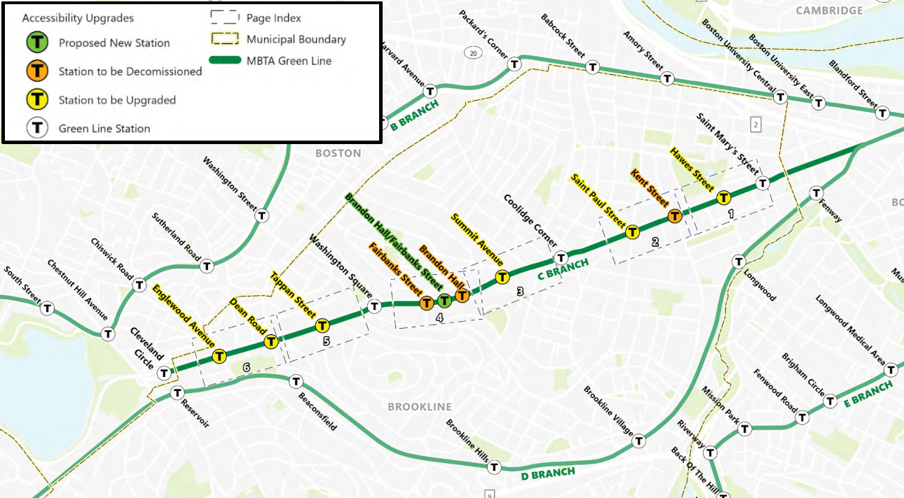
In the alternatives with a "Brandon Hall/Fairbanks Street", I get that's probably just to communicate which two stations it's replacing, but with the diagram they drew Fairbanks Street really has no relation to the station.
 
In the alternatives with a "Brandon Hall/Fairbanks Street", I get that's probably just to communicate which two stations it's replacing, but with the diagram they drew Fairbanks Street really has no relation to the station.
I would hope this is just a placeholder name for planning documents and if the town of Brookline asked for a different name, they would get it. Frankly, I wouldn't be surprised if it just becomes "Brandon Hall" after all the paperwork is filed, but the planners are concerned about residents upset over station removal.

It's also a shame not seeing more details on the alternative analysis. It would be very informative to see direct comparisons of the option considered on groups of stations. Think keeping Kent St vs removal, Brandon Hall removal vs consolidation with Fairbanks Street, and varying removals of Dean Rd and Englewood Ave. Not seeing travel time changes, walk time changes, or current assumed ridership station by station also makes it harder to understand how the final numbers were reached. Adding cost and reliability to the consolidation criteria (both of which are clearly important) would likely result in a more favorable outlook to more consolidation, which is probably best in the long-term.
I still don't understand keeping Englewood Ave and Dean Road, especially with Cleveland Circle being moved east of Ayr road. The distance between the outbound platforms of Englewood Ave and CC at their closest will be around 450ft, it's comically short. Englewood Ave to Dean Road would be the same as it is today, ~600ft, which is hardly better.

Yes I know it's the end of the line so you'd only be saving 30 seconds for the people at Cleveland Circle, but surely you could find a better use for $5.5 million than building an essentially redundant station.
 
In the alternatives with a "Brandon Hall/Fairbanks Street", I get that's probably just to communicate which two stations it's replacing, but with the diagram they drew Fairbanks Street really has no relation to the station.
Brandon Hall burned down in 1946 and has been a name that means absolutely nothing in terms of a location/wayfinding aid for 80 years, so I'm not sure that's really a better portion of the name to retain.
Think keeping Kent St vs removal

Kent + Hawes are very low ridership and have limited at best potential for ridership growth given local development patterns + zoning. I can agree that I'd still like to know more about the decisionmaking and why they went with Kent vs Hawes, but I think it's incredibly obvious that they should be consolidated from 2->1 in some form, especially with their position on the line meaning far more people are delayed by the unnecessary stop vs near the far end.

My assumption though is that St. Mary's comes under moderate strain, especially in terms of the more savvy riders post-Fenway events, and that pushing some fraction of Hawes riders to it is less optimal than pushing some fraction of Kent riders to the lower ridership + less prone to event-driven ridership St. Paul is.
 
I still don't understand keeping Englewood Ave and Dean Road, especially with Cleveland Circle being moved east of Ayr road. The distance between the outbound platforms of Englewood Ave and CC at their closest will be around 450ft, it's comically short. Englewood Ave to Dean Road would be the same as it is today, ~600ft, which is hardly better.

Yes I know it's the end of the line so you'd only be saving 30 seconds for the people at Cleveland Circle, but surely you could find a better use for $5.5 million than building an essentially redundant station.
Cleveland Circle would not be flipped across Ayr Road - the platforms would just be extended east slightly from their existing position, closing the grade crossing. The distance between the center of the stations would continue to be approximately 1,100 feet. Platform tip to platform tip isn't a useful measurement of stop spacing, especially when platforms can only be accessed at traffic signals. (While I would like to see actual crosswalks be put in at the end of the platforms, that doesn't seem likely to happen.)

Current spacing on the east end is:
SP - 800 - KS - 1000 - HS - 1000 - SM
The actual stop spacing after this work will be:
CC - 1100 - EA - 850 - DR - 950 - TS - 1050 - WS - 1450 - FS/BH - 1000 - SA - 1350 - CC - 1200 - SP - 1800 - HS - 1000 - SM

To my mind, that's perfectly acceptable for a relatively short light rail line where the vast majority of ridership is walk-up and there is continuous multistory development along the road. This isn't a greenfield route where stations are focused around TOD and bus nodes - it's a route where the development is a result of having 136 years of the ability to walk to a nearby station.
 

Back
Top