Looking at the connection, incorporating bus lanes on the rebuilt bridge would really only be helpful for inbound from the south and outbound to the north. Bus lanes on Seaport Blvd would be a much better plan for improving that aspect. I'd say build the bridge to support one lane vehicle traffic in each direction with sidewalk in case it is needed during a bridge closure. In practice, the "lanes" will be pedestrian and emergency vehicles only and the sidewalk will be cycle track. Design shouldn't preclude the alt usage, but should be made to look for pedestrians and not just a road that people walk on.
You are using an out of date browser. It may not display this or other websites correctly.
You should upgrade or use an alternative browser.
You should upgrade or use an alternative browser.
Northern Avenue Bridge Fort Point Channel
- Thread starter statler
- Start date
stick n move
Superstar
- Joined
- Oct 14, 2009
- Messages
- 13,490
- Reaction score
- 24,579
I mean its really not too hard to visualize how much it would be used as a pedestrian only corridor... seeing that thats exactly what it was before it closed. Even back then when there was only 1mpd, the court house, the 2 vertex towers, and the ICA tons of people used it and everytime I crossed there was a few other people crossing as well. So it definitely would be used again now that theres a lot more going on there. I used to use it any time I was between seaport blvd and the harbor because it was flat and a straight shot. These days theres a whole neighborhood there and pier 4 is wrapping up now too.
If it were to be used by cars again a one way 2 lane bridge out of the seaport would help seaport traffic the most. Taking the right from downtown onto the bridge is redundant with the moakley bridge just before it, so thats unnessecary. So instead both lanes would lead out of the seaport and right turn only. If you need to go straight across or left onto atlantic ave you just take the moakley as normal. Heading out of the seaport though it leads right into a one way right turn only at atlantic ave. This would allow all cars who wish to head north on atlantic ave an easy route. People learn the roads so people would learn to take northern ave to go right and the moakley bridge to go straight or left.
If it were to be used by cars again a one way 2 lane bridge out of the seaport would help seaport traffic the most. Taking the right from downtown onto the bridge is redundant with the moakley bridge just before it, so thats unnessecary. So instead both lanes would lead out of the seaport and right turn only. If you need to go straight across or left onto atlantic ave you just take the moakley as normal. Heading out of the seaport though it leads right into a one way right turn only at atlantic ave. This would allow all cars who wish to head north on atlantic ave an easy route. People learn the roads so people would learn to take northern ave to go right and the moakley bridge to go straight or left.
JeffDowntown
Senior Member
- Joined
- May 28, 2007
- Messages
- 5,049
- Reaction score
- 4,229
If it were to be used by cars again a one way 2 lane bridge out of the seaport would help seaport traffic the most. Taking the right from downtown onto the bridge is redundant with the moakley bridge just before it, so thats unnessecary. So instead both lanes would lead out of the seaport and right turn only. If you need to go straight across or left onto atlantic ave you just take the moakley as normal. Heading out of the seaport though it leads right into a one way right turn only at atlantic ave. This would allow all cars who wish to head north on atlantic ave an easy route. People learn the roads so people would learn to take northern ave to go right and the moakley bridge to go straight or left.
I think you are missing a key point about the traffic flow out of the Seaport.
The right turn most cars are making coming off the Moakley Bridge is not onto Atlantic. It is into the O'Neill Tunnel, I-93 N. The Northern Avenue Bridge provides no such access; it just dumps cars onto a busy, one-way stretch of Atlantic Ave, far from an I-93 entrance.
So I attended the public meeting tonight. It seems apparent that Marty’s default position is to go with cars on the bridge. Barring significant pushback, it’s cars, cars, cars. It’s also apparent that the city sees the budget as the greatest weak point in making the bridge car-centric. Arguments based on use will not carry much water, but arguments on the money involved may be persuasive.
I think you are missing a key point about the traffic flow out of the Seaport.
The right turn most cars are making coming off the Moakley Bridge is not onto Atlantic. It is into the O'Neill Tunnel, I-93 N. The Northern Avenue Bridge provides no such access; it just dumps cars onto a busy, one-way stretch of Atlantic Ave, far from an I-93 entrance.
Well... as someone who has gone through there many times, everybody is trying to get onto 93, just from different entrances like at Sudbury and through Sullivan. The reconstruction of the Charlestown bridge is going to mess with this. If they really wanted to help, a bus lane to North Station would be the easiest way to reduce traffic.
stick n move
Superstar
- Joined
- Oct 14, 2009
- Messages
- 13,490
- Reaction score
- 24,579
odurandina
Senior Member
- Joined
- Dec 1, 2015
- Messages
- 5,328
- Reaction score
- 266
My God: we're still at the 'talking about the bridge for years' stage? :roll:
So I attended the public meeting tonight. It seems apparent that Marty’s default position is to go with cars on the bridge. Barring significant pushback, it’s cars, cars, cars.....
Last edited:
FormFollowsBudget
Senior Member
- Joined
- Jan 15, 2015
- Messages
- 2,319
- Reaction score
- 4,106
The contextual version (3rd bridge option) in the second video is an instant icon, I think. The reinterpreted version is strange, and the basic is, well, basic..
HenryAlan
Senior Member
- Joined
- Dec 15, 2009
- Messages
- 4,474
- Reaction score
- 5,258
Of the four presented in the second video, I like the second one far more than the others. It is modern, yet still referential to the original design.
Of the four presented in the second video, I like the second one far more than the others. It is modern, yet still referential to the original design.
It also was a nod to pilings and the historical wharves. I like it, but my preference would be a restoration of the original metal. The best part of that bridge is the wooden floor and the metal overhead. I hope they preserve the former regardless of design (tho I doubt it).
Randomgear
Active Member
- Joined
- Jul 7, 2012
- Messages
- 364
- Reaction score
- 46
The first video is so close - just remove the damned roadway across the water. keep a narrow bike/ped bridge and the island in the middle of the Channel as a car-free hangout on the water.
Equilibria
Senior Member
- Joined
- May 6, 2007
- Messages
- 7,230
- Reaction score
- 8,761
First official design (courtesy of Streetsblog, so blame them for the quality ") ). It's undecided what the support would be (which is a lot of the aesthetics), but there would be no non-emergency vehicle use.
). It's undecided what the support would be (which is a lot of the aesthetics), but there would be no non-emergency vehicle use.

). It's undecided what the support would be (which is a lot of the aesthetics), but there would be no non-emergency vehicle use.- Joined
- Jan 22, 2012
- Messages
- 5,078
- Reaction score
- 1,662
City Embraces 'People-First' Design For Northern Ave. Bridge Replacement - Streetsblog Massachusetts
In deference to the city's climate goals, officials say there will be "no cars" on the new bridge between the Seaport and Financial District.mass.streetsblog.org
King of Sheeba posted the streetsblog article in another thread. Relevant here as well.
- Joined
- Jan 7, 2012
- Messages
- 14,173
- Reaction score
- 23,688
King of Sheeba posted the streetsblog article in another thread. Relevant here as well.
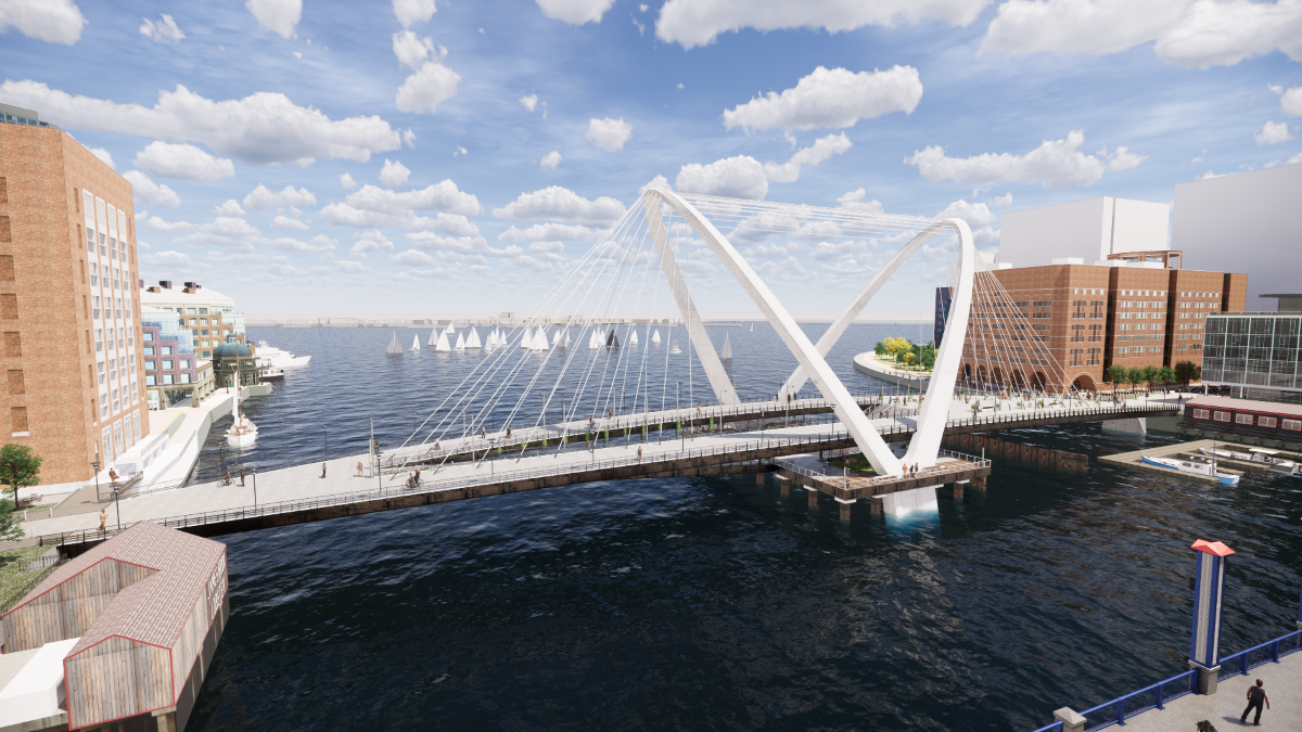
 02_Double-Arch-02-Aerial by Bos Beeline, on Flickr
 01_Girder-Truss-02-Aerial-1 by Bos Beeline, on Flickr
 00_Girder-No-Truss-02-Aerial by Bos Beeline, on Flickr
 IMG_0849 by Bos Beeline, on Flickr
I vote for the Double Arch version.
Equilibria
Senior Member
- Joined
- May 6, 2007
- Messages
- 7,230
- Reaction score
- 8,761

Boston has dramatically reworked the design for a new Northern Avenue bridge - The Boston Globe
City officials working on replacing the long-closed bridge over Fort Point Channel appear to be moving toward a span that would prioritize walking and bicycling and prohibit single-occupancy cars. Indeed, conceptual images shared Tuesday don’t show any vehicles.
 www.bostonglobe.com
Slightly misleading image there - implying the City has selected the double-arch when it hasn't - but that's my favorite so if they're making it more likely that's good news to me.
One span — accommodating one lane of traffic — would be devoted to buses, shuttles, and emergency vehicles. A separate span — on the harbor side — and the space below it would be for walkers, bikers, or just a place for people to congregate. While the bridge would be planned to “evolve” with the city’s transportation needs, officials said, there are no plans to allow regular car traffic.
City engineers are aiming for more specific designs by spring, and “100 percent design” in 2021. They would break ground a year after that and construction would take an additional two to three years. That means a bridge could open in 2025, a little more than a decade after it was shuttered because of safety concerns.
- Joined
- Dec 10, 2011
- Messages
- 5,599
- Reaction score
- 2,719
Can they do that: have ADA ramp at the "city" end and only steps at the "Seaport" end? (We sometimes want to have double-ended rail stations where one end only has stairs--I remember asking for steps from the platorm-ends at the Newmarket CR stop and was told "no if you're going to put stairs, there has to be a matching ramp")
When's the old one supposed to fall down? Crazy this takes over a decade to fix. Coast Guard sent a letter in the winter of 2016 saying the collapse was imminent. Doesn't look like they've done anything to shore it up either.