You are using an out of date browser. It may not display this or other websites correctly.
You should upgrade or use an alternative browser.
You should upgrade or use an alternative browser.
Northern Avenue Bridge Fort Point Channel
- Thread starter statler
- Start date
It should be knocked down and replaced with a tied arch bridge. You could have this all done in a week.Unpopular opinion: the Northern Avenue Bridge was ugly the day it was built. No idea why so much importance is attached to preserving it.
stick n move
Superstar
- Joined
- Oct 14, 2009
- Messages
- 12,112
- Reaction score
- 18,983
It should be knocked down and replaced with a tied arch bridge. You could have this all done in a week.
Agree 100%. It would be cheap, easy to float in and jack up into place, and it would look good too. Win win win.
Brattle Loop
Senior Member
- Joined
- Apr 28, 2020
- Messages
- 1,167
- Reaction score
- 2,084
It should be knocked down and replaced with a tied arch bridge. You could have this all done in a week.
Agree 100%. It would be cheap, easy to float in and jack up into place, and it would look good too. Win win win.
Would there be any problem doing that given that the current bridge is a (locked-open) swing bridge? I feel like the feds might have some issues with sticking a fixed bridge over what I think is still technically a navigable waterway. (And rebuilding the approaches to have a higher fixed span isn't a drop-in replacement.)
Of course, the channel still being Coast Guard jurisdiction at all seems a little ridiculous at this point (not that that argument is necessarily persuasive to the feds, well, ever).
Justbuildit
Active Member
- Joined
- Nov 27, 2022
- Messages
- 861
- Reaction score
- 2,960
Every other bridge across the channel (Seaport BLVD, Congress, Summer) is inoperable or was built fixed. Unless there’s something special on the block between Northern and Seaport it shouldn’t make a difference. I like having something there for the pedestrian experience but I agree, scrap it all and build it into the new dam/gates with a simple fixed structure
Brattle Loop
Senior Member
- Joined
- Apr 28, 2020
- Messages
- 1,167
- Reaction score
- 2,084
Every other bridge across the channel (Seaport BLVD, Congress, Summer) is inoperable or was built fixed. Unless there’s something special on the block between Northern and Seaport it shouldn’t make a difference. I like having something there for the pedestrian experience but I agree, scrap it all and build it into the new dam/gates with a simple fixed structure
Yeah, but the clearance under Seaport Boulevard's quite a bit higher than the deck level of the Northern Avenue bridge (probably how it could be built as a fixed span). I agree that a fixed span for the Northern Avenue replacement is probably possible, just that it probably requires more than a simple drop-in replacement unless the state can get the channel declared non-navigable.
stellarfun
Senior Member
- Joined
- Dec 28, 2006
- Messages
- 5,711
- Reaction score
- 1,544
Boston's highest high water is 15.16 feet. From the graphic, the gates would apparently protect against a crest of 15.5 feet. Not much margin, unless the bridge deck provides an additional 2-3 feet, which might explain the chunky blocks instead of svelte piers. (That said, I did not check the crest height for the option, which probably can be found in the engineering drawings.)
Below is the base concept for the barrier. Combining the barrier with a new Northern Avenue bridge is the alternate. Pick your poison


Engineering drawings for both can be found here.
https://www.bwsc.org/news-and-events/news/coastal-stormwater-discharge-analysis-project
^^^ Go to Fort Point
Below is the base concept for the barrier. Combining the barrier with a new Northern Avenue bridge is the alternate. Pick your poison


Engineering drawings for both can be found here.
https://www.bwsc.org/news-and-events/news/coastal-stormwater-discharge-analysis-project
^^^ Go to Fort Point
BosMaineiac
Active Member
- Joined
- Nov 25, 2020
- Messages
- 217
- Reaction score
- 397
Maybe now would be a good time to start talking about a big barrier…Boston's highest high water is 15.16 feet. From the graphic, the gates would apparently protect against a crest of 15.5 feet. Not much margin, unless the bridge deck provides an additional 2-3 feet, which might explain the chunky blocks instead of svelte piers. (That said, I did not check the crest height for the option, which probably can be found in the engineering drawings.)
Below is the base concept for the barrier. Combining the barrier with a new Northern Avenue bridge is the alternate. Pick your poison


Engineering drawings for both can be found here.
https://www.bwsc.org/news-and-events/news/coastal-stormwater-discharge-analysis-project
^^^ Go to Fort Point
Charlie_mta
Senior Member
- Joined
- Jul 15, 2006
- Messages
- 4,563
- Reaction score
- 6,491
I like the location of the proposed pedestrian bridge, further north than the old Northern Ave bridge. The proposed location would provide a shorter and more direct pedestrian and bike route from the Downtown waterfront to the Seaport waterfront.Boston's highest high water is 15.16 feet. From the graphic, the gates would apparently protect against a crest of 15.5 feet. Not much margin, unless the bridge deck provides an additional 2-3 feet, which might explain the chunky blocks instead of svelte piers. (That said, I did not check the crest height for the option, which probably can be found in the engineering drawings.)
Below is the base concept for the barrier. Combining the barrier with a new Northern Avenue bridge is the alternate. Pick your poison


Engineering drawings for both can be found here.
https://www.bwsc.org/news-and-events/news/coastal-stormwater-discharge-analysis-project
^^^ Go to Fort Point
- Joined
- Dec 10, 2011
- Messages
- 5,599
- Reaction score
- 2,717
I visited Des Moines Iowa, and, I gotta say, their ability to build dramatic,functional bike-ped-only bridges seems several levels above Boston's game.
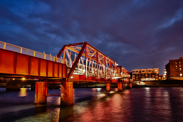
Downtown Rehabbing a rail bridge into bike/ped:
Des Moines Union Railway Bridge (south crossing for the downtown riverwalk)
 Pedestrian Bridge HDR - Des Moines, Iowa (Project 50/50 - Week 16) by Jason Mrachina, on Flickr
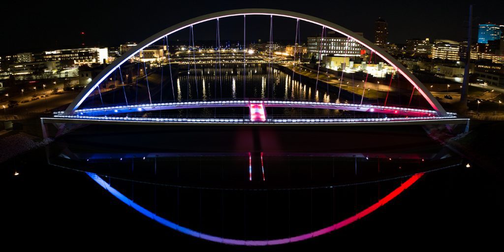
Iowa Women of Achievement Bridge: single-arch, double-bikeway bridge (north crossing for the downtown riverwalk)

44th Street bridge (two arch, single ROW) (over interstate on its approach to downtown)

How does Des Moines pull this off and not Boston?
I'd be thrilled to get off-the-shelf derivatives of either of these arch bridges.
Downtown Rehabbing a rail bridge into bike/ped:
Des Moines Union Railway Bridge (south crossing for the downtown riverwalk)
 Pedestrian Bridge HDR - Des Moines, Iowa (Project 50/50 - Week 16) by Jason Mrachina, on Flickr
Iowa Women of Achievement Bridge: single-arch, double-bikeway bridge (north crossing for the downtown riverwalk)

44th Street bridge (two arch, single ROW) (over interstate on its approach to downtown)
How does Des Moines pull this off and not Boston?
I'd be thrilled to get off-the-shelf derivatives of either of these arch bridges.
Last edited:
JeffDowntown
Senior Member
- Joined
- May 28, 2007
- Messages
- 4,795
- Reaction score
- 3,662
You said why in your first sentence. They went pure bike/ped. Low cost and focused. They cut down the number of cooks in the kitchen. We try for bike/ped/bus/emergency vehicle/park, scenic overlook, historic recreation.... We end up with a Frankenstein's monster of a design.I visited Des Moines Iowa, and, I gotta say, their ability to build dramatic,functional bike-ped-only bridges seems several levels above Boston's game.
Downtown Rehabbing a rail bridge into bike/ped:
Des Moines Union Railway Bridge (south crossing for the downtown riverwalk)
Pedestrian Bridge HDR - Des Moines, Iowa (Project 50/50 - Week 16) by Jason Mrachina, on Flickr
Iowa Women of Achievement Bridge: single-arch, double-bikeway bridge (north crossing for the downtown riverwalk)

44th Street bridge (two arch, single ROW) (over interstate on its approach to downtown)
View attachment 35073
How does Des Moines pull this off and not Boston?
I'd be thrilled to get off-the-shelf derivatives of either of these arch bridges.
citydweller
Active Member
- Joined
- Aug 23, 2019
- Messages
- 438
- Reaction score
- 684

The Northern Avenue bridge is finally heading for the scrap heap. What could rise in its place? - The Boston Globe
Even as the vestige of the waterfront’s industrial past is slated for demolition, the idea of building a new span across the mouth of the Fort Point Channel lives on.
themissinglink
Senior Member
- Joined
- Jan 13, 2018
- Messages
- 1,507
- Reaction score
- 3,830
I wish the replacement span was a priority, but it doesn’t seem like there’s any chance of it happening anytime soon.
citydweller
Active Member
- Joined
- Aug 23, 2019
- Messages
- 438
- Reaction score
- 684
At least they are finally getting rid of the blight of the neighborhood. Once removed, then perhaps that will be the impetus to get something aesthetically pleasing and functional.I wish the replacement span was a priority, but it doesn’t seem like there’s any chance of it happening anytime soon.
Charlie_mta
Senior Member
- Joined
- Jul 15, 2006
- Messages
- 4,563
- Reaction score
- 6,491
I agree, and I do like the old bridge. If the steel truss were sandblasted and repainted, have some really cool complimentary accessories placed on it, and have some interesting lighting at night, it would look great. But then again, I like the old industrial look, including truss bridges. I mean, look at this beauty:It would be great to see a new bridge but I'm not happy about this. It is a piece of history, and it is only ugly because it is neglected, same as the Hotel Alexandra
Longfellow
Active Member
- Joined
- Dec 12, 2023
- Messages
- 296
- Reaction score
- 719
I think the bridge is structurally unsafe right? Which is why they rotated it and it’s no longer used for walking.
stick n move
Superstar
- Joined
- Oct 14, 2009
- Messages
- 12,112
- Reaction score
- 18,983
Yep
