You are using an out of date browser. It may not display this or other websites correctly.
You should upgrade or use an alternative browser.
You should upgrade or use an alternative browser.
Photo of the Day, Boston Style: Part V (2012)
- Thread starter DZH22
- Start date
- Status
- Not open for further replies.
Boston02124
Senior Member
- Joined
- Sep 6, 2007
- Messages
- 6,893
- Reaction score
- 6,639
I really like the top pix! So many different building's from different era's plus the solid wall look,no blue sky!


JohnAKeith
Senior Member
- Joined
- Dec 24, 2008
- Messages
- 4,337
- Reaction score
- 82
A Then and Now.
Pardon me if I've asked this question before, but what view is it in this Childe Hassam painting? I've always assumed it's of Tremont Street on the edge of the Common, heading away from Park Street station toward Boylston Street station. No?
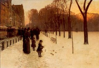
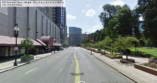
This would be a similar view today, I guess, although about 50 feet to the left of where mother and child stood in the original. (View from in front of Tremont-on-the-Common at 151 Tremont Street.)
The only confusion I've had is over the sun setting in the distance. It seems to be very bright to be on the southern hemisphere; I'd expect to see that color of sky in the west, not the south.
Of course, the painting was done during the winter, so perhaps the sun sets that low during that time.
Thoughts?
Pardon me if I've asked this question before, but what view is it in this Childe Hassam painting? I've always assumed it's of Tremont Street on the edge of the Common, heading away from Park Street station toward Boylston Street station. No?
This would be a similar view today, I guess, although about 50 feet to the left of where mother and child stood in the original. (View from in front of Tremont-on-the-Common at 151 Tremont Street.)
The only confusion I've had is over the sun setting in the distance. It seems to be very bright to be on the southern hemisphere; I'd expect to see that color of sky in the west, not the south.
Of course, the painting was done during the winter, so perhaps the sun sets that low during that time.
Thoughts?
BostonObserver
Active Member
- Joined
- Dec 26, 2006
- Messages
- 573
- Reaction score
- 103
You are correct.


whighlander
Senior Member
- Joined
- Aug 14, 2006
- Messages
- 7,812
- Reaction score
- 647
A Then and Now.
Pardon me if I've asked this question before, but what view is it in this Childe Hassam painting? I've always assumed it's of Tremont Street on the edge of the Common, heading away from Park Street station toward Boylston Street station. No?
This would be a similar view today, I guess, although about 50 feet to the left of where mother and child stood in the original. (View from in front of Tremont-on-the-Common at 151 Tremont Street.)
The only confusion I've had is over the sun setting in the distance. It seems to be very bright to be on the southern hemisphere; I'd expect to see that color of sky in the west, not the south.
Of course, the painting was done during the winter, so perhaps the sun sets that low during that time.
Thoughts?
John,
Tremont St. at the corner of Park to the middle of that section of the Common - doesn't run N-S -- actual axis is toward SW -- precisely where you expect the sun to be setting in Dec - January when presumably the painting was done
C
cozzyd
Guest
I was sitting in North Point Park and heard something that sounded like an air raid siren. Then the railroad bridge went up.

JohnCostello
Active Member
- Joined
- May 14, 2008
- Messages
- 299
- Reaction score
- 273
A Then and Now.
Pardon me if I've asked this question before, but what view is it in this Childe Hassam painting? I've always assumed it's of Tremont Street on the edge of the Common, heading away from Park Street station toward Boylston Street station. No?
This would be a similar view today, I guess, although about 50 feet to the left of where mother and child stood in the original. (View from in front of Tremont-on-the-Common at 151 Tremont Street.)
The only confusion I've had is over the sun setting in the distance. It seems to be very bright to be on the southern hemisphere; I'd expect to see that color of sky in the west, not the south.
Of course, the painting was done during the winter, so perhaps the sun sets that low during that time.
Thoughts?
Dorchester Painter Childe Hasham took a little liberty with the placement of the sun in this painting in order to get the sun right. If the sun ever sets in that position, we are in some version of the movie 2012.
whighlander
Senior Member
- Joined
- Aug 14, 2006
- Messages
- 7,812
- Reaction score
- 647
Dorchester Painter Childe Hasham took a little liberty with the placement of the sun in this painting in order to get the sun right. If the sun ever sets in that position, we are in some version of the movie 2012.
John, John, et al
Yesterday I was at the MFA and i took a good look at the painting
The painting really depicts the Common along Tremont close to where Boylston and Tremont meet -- the woman is standing essentially where the Boylston Station Head northern most House is located about opposite the AMC Movie Theater
At the middle right of the painting you can see the lights from buildings on Boylston St.
Note that the Tremont / Boylston Corner is not a right angle: Tremont near to the corner is running to the West of South while Boylston is nearly E-W although it heads a bit North of West
http://maps.google.com/?ll=42.352867,-71.065536&spn=0.003639,0.006427&t=h&z=17
In the winter the sun always rises and sets south of west -- the E-W alignment occurs only on the Spring and Autumnal Equinoxes. Go out this morning or tomorrow PM and you will see the sun is now rising N of E and setting N of W (297.45 Clockwise from North or nearly pointing toward the intesection of Charles and Beacon)
There is a bit of a further complication in that when the Green Line was being built and the Boylston Station constructed about 10 years after the painting -- the Boylston / Tremont corner of the Common was dug up and things moved (e.g. graves, trees, buildings, streets)
Anyway using the NOAA solar calcularor
http://www.esrl.noaa.gov/gmd/grad/solcalc/
setting the date to be Dec 31 the sun sets at 238.51 (clockwise from true North where W would be 270) or toward the corner of the Common where Charles and Boylston currently intersect (just south of the Ball field)
So perhaps Hassam didnn't quite remember where the sun should set -- but he was quite close
whighlander
Senior Member
- Joined
- Aug 14, 2006
- Messages
- 7,812
- Reaction score
- 647
I was sitting in North Point Park and heard something that sounded like an air raid siren. Then the railroad bridge went up.
Cozzy -- It does that -- they want to warn a train approaching the bridge that it might not be there
Other sounds associated with the Cragie Bridge for cars and people and also the locks at the Charles River Dam
throw in the quacking when the Duck Tour boat hits the water -- that's one noisey corner of Boston
Ron Newman
Senior Member
- Joined
- May 30, 2006
- Messages
- 8,395
- Reaction score
- 13
I was sitting in North Point Park and heard something that sounded like an air raid siren. Then the railroad bridge went up.
The nearby Craigie Bridge also has a siren sound just before the barrier gates close.
GMACK24
Active Member
- Joined
- Dec 29, 2007
- Messages
- 609
- Reaction score
- 1

JohnAKeith
Senior Member
- Joined
- Dec 24, 2008
- Messages
- 4,337
- Reaction score
- 82
JohnAKeith
Senior Member
- Joined
- Dec 24, 2008
- Messages
- 4,337
- Reaction score
- 82

Shepard
Senior Member
- Joined
- Mar 20, 2009
- Messages
- 3,518
- Reaction score
- 68
From the Globe:
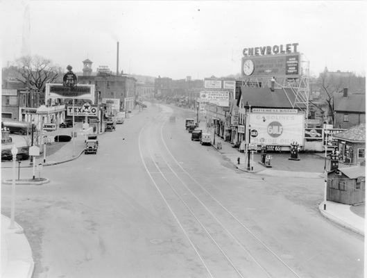
"Brookline Village in the 1930s looking west on Route 9, from the intersection at Pond Ave. The fire department tower is pictured in the background on the left."
Even though the explanation is straightforward, I'm still having a hard time making sense of this.
"Brookline Village in the 1930s looking west on Route 9, from the intersection at Pond Ave. The fire department tower is pictured in the background on the left."
Even though the explanation is straightforward, I'm still having a hard time making sense of this.
kz1000ps
Senior Member
- Joined
- May 28, 2006
- Messages
- 8,975
- Reaction score
- 11,747
A trip to www.historicaerials.com should clear thing up...the photo was taken from the Jamaicaway overpass with Pond Ave. directly to your left and the intersection with Brookline Ave. up a hundred yards in the mid-background. The only thing that is remotely the same today is the Gulf station at Brookline and Rt. 9: http://g.co/maps/77arg
Here's what the area looked like in 1955:

Here's what the area looked like in 1955:
BostonUrbEx
Senior Member
- Joined
- Mar 13, 2010
- Messages
- 4,340
- Reaction score
- 130
Do you kiss your mother with that mouth?
- Status
- Not open for further replies.