Proposed But Never Built

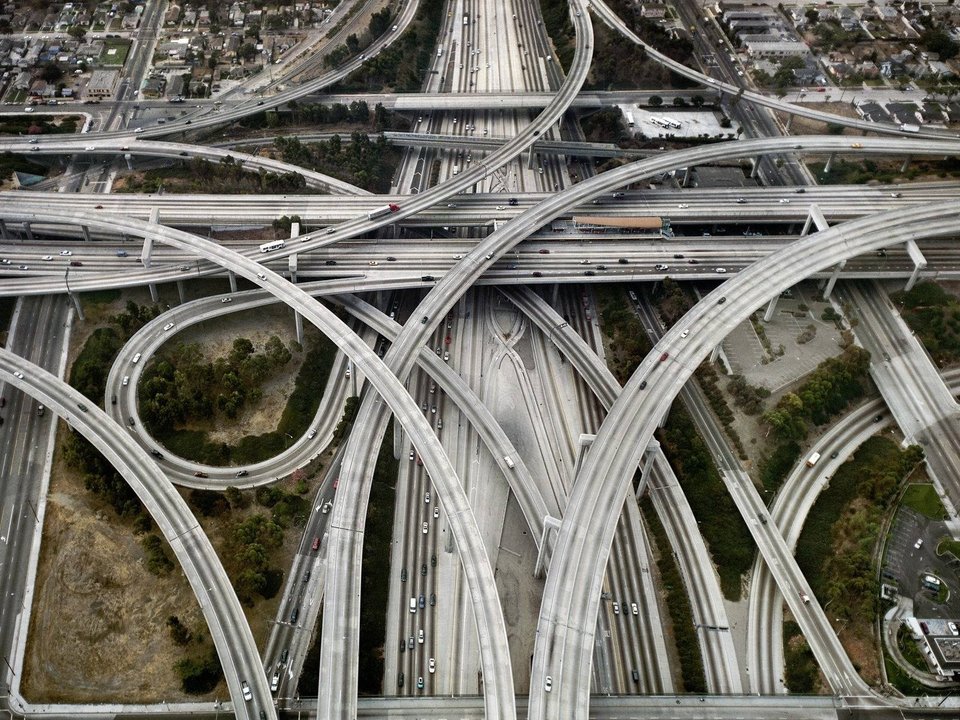
You have to strike a balance. The 110/105 spaghetti's is an unsung hero, that helps in a great balancing act within the LA Freeway system.

 
John and Charlie those are awesome. Thank you for posting!
 
I wonder if those images from the City of Boston Archive are of an early version of the map room at the BPDA (then BRA of course). Looks similar to me.

Visit if you haven't. Anyone who spends any time on aB would get a lot out of it. (http://www.bostonplans.org/about-us/model-room)
 
Here's a sweet one. The 1969 proposed Route 2 interchange at Alewife Brook Parkway. The view faces north. Route 2 to Lexington goes off to the left. The Red Line extension curves west towards Belmont/Waltham instead of Arlington. I grew up about two blocks from this location.

47182639882_c369a12667_b.jpg

Jesus that's terrifying.
 
what's truly terrifying is the swath of tract-housing the artist envisioned for poor arlington and belmont. yikes.
 
what's truly terrifying is the swath of tract-housing the artist envisioned for poor arlington and belmont. yikes.

Looks like the highway rendering depicts Arlington accurately. Here is Alewife today:

33367802528_2e2830d401_b.jpg
 
you think that dense, non-homogenous, non grid-style area in the upper and upper-left portion of the photo is accurately depicted by the tract houses in the same area of the 1969 render? ok.
 
you think that dense, non-homogenous, non grid-style area in the upper and upper-left portion of the photo is accurately depicted by the tract houses in the same area of the 1969 render? ok.

I think that was a case of a lazy render. The houses in the actual picture were already there in 1969, so we shouldn't think the render was suggesting tearing them out and replacing them, so much as that it was showing that the area was residential.
 
If the aerial photo were at the same angle as the rendering, Arlington would be laid out the same in both. The rendering did minimize the presence of trees, which changes the look quite a bit. Apparently, trees weren't popular in the late 1960's.
 
I found this while browsing Roger Ferris + Partners' site. RF+P is the architect behind the Kenmore North development.

I'm sure this is intentional, but I cannot place it: "Eagle Commons"
https://www.ferrisarch.com/eagle-commons.html

My guess would be Eastie based on the name, but that's all I've got.
 
I would say somewhere closer to downtown because the website mentions "the adjacent towers" and there are no towers in Eagle Hill. There is a gridded building in the rendering, but I've never seen it.
 
My guess would be Eastie based on the name, but that's all I've got.

Given Eagle Hill's proximity to overflight from 15/33, a tower of this scale would be a non-starter in East Boston.

I like the design. It would look pretty cool on the recently sold Gillette property.
 
Any renderings of Longfellow Place or Harbor Towers with three towers? Both planned with three ended up building only two.
 

Back
Top