You are using an out of date browser. It may not display this or other websites correctly.
You should upgrade or use an alternative browser.
You should upgrade or use an alternative browser.
Proposed But Never Built
- Thread starter Boston02124
- Start date
FormFollowsBudget
Senior Member
- Joined
- Jan 15, 2015
- Messages
- 2,318
- Reaction score
- 4,106
For some reason I feel... itchy looking at this..An early concept for Brigham & Women’s Hospital.

An early concept for Brigham & Women’s Hospital.
We did end up with 1 of those things, slightly modified.
Google Maps
Find local businesses, view maps and get driving directions in Google Maps.
Wasn't there a small tower with the same style in Chicago or NYC recently demolished (last 2-3 years)? Same architect?
Chicago ...
https://en.m.wikipedia.org/wiki/Prentice_Women's_Hospital_Building
F-Line to Dudley
Senior Member
- Joined
- Nov 2, 2010
- Messages
- 9,970
- Reaction score
- 12,302
An early concept for Brigham & Women’s Hospital.
Looks like a plate taken from Audubon's Field Guide to Deep Sea Sponges.

Charlie_mta
Senior Member
- Joined
- Jul 15, 2006
- Messages
- 5,150
- Reaction score
- 7,777
Looks like rolled-up bandages, apropos for a hospital.
KentXie
Senior Member
- Joined
- May 25, 2006
- Messages
- 4,210
- Reaction score
- 834
You have trypophobia like meFor some reason I feel... itchy looking at this..
Charlie_mta
Senior Member
- Joined
- Jul 15, 2006
- Messages
- 5,150
- Reaction score
- 7,777
I mapped the routes from the Master Highway Plan - 1948 - onto this Go9gle map: https://www.google.com/maps/d/edit?...ll=42.359516466959775,-71.10399860085448&z=11
Very painstakingly done to be as exact as possible.
Some observations about the routes:
- The old rail yards, rail lines and industrial buildings were avoided, but the residential neighborhoods were pounced upon and blitzed by these routes.
- The Northwest Expressway goes right through the middle of Winchester, a political impossibility now (and back then as well, I'm sure).
- The Mystic Valley Parkway and many other parklands would have been blitzed by the routes.
- Overall very ambitious for pre-Interstate 90% Federal funding, which didn't happen until 1956.
- Joined
- May 25, 2006
- Messages
- 7,064
- Reaction score
- 1,990
What exactly is this based on? I've never seen these routes before.
It’s based on this: https://archive.org/details/masterhighwaypla00char/mode/2up
Charlie_mta
Senior Member
- Joined
- Jul 15, 2006
- Messages
- 5,150
- Reaction score
- 7,777
The routes are from the Master Highway Plan - 1948 - For The Metropolitan Boston Area. I've known about it since about 1971, and downloaded it a few years ago from https://archive.org/details/masterhighwaypla00char/mode/2upWhat exactly is this based on? I've never seen these routes before.
It's a fascinating read. This was the first comprehensive expressway system proposed for the greater Boston metro area. From 1948 to 1956 isn't a long time, but the routes changed dramatically, especially I-93 north through Medford and Stoneham, the (unbuilt) Northwest Expressway (Route 2 through Cambridge), and the (unbuilt) Inner Belt Expressway. The final expressway routes planned by 1969 were far superior to these 1948 routes in my opinion. The 1969 routes tried to avoid neighborhoods as much as possible, whereas the 1948 routes plowed straight through the middle of many of them.
The 1948 routes were shaped by a different time in which heavy industry and railroad lines and yards were dominant, and thus were pretty much avoided by the 1948 routes; probably a legacy from WW II in which the nation was heavily dependant on these. By 1969, the planned expressway routes were shifted over to the declining railroad yards and industrial properties.
The irony of these many expressway plans and designs over a 3 decade span was that only a fraction of them actually got built. I regret that in some ways, looking at the gridlock we deal with today (COVID-19 reduced traffic aside, of course). But metro Boston would have been far more sprawling with a decimated core if all of these had been built. So I can see both sides.
Last edited:
F-Line to Dudley
Senior Member
- Joined
- Nov 2, 2010
- Messages
- 9,970
- Reaction score
- 12,302
The routes are from the Master Highway Plan - 1948 - For The Metropolitan Boston Area. I've known about it since about 1971, and downloaded it a few years ago from https://archive.org/details/masterhighwaypla00char/mode/2up
It's a fascinating read. This was the first comprehensive expressway system proposed for the metropolitan Boston Expressway system. From 1948 to 1956 isn't a long time, but the routes changed dramatically, especially I-93 north through Medford and Stoneham, the (unbuilt) Northwest Expressway (Route 2 through Cambridge), and the (unbuilt) Inner Belt Expressway. The final expressway routes planned by 1969 were far superior to these 1948 routes in my opinion. The 1969 routes tried to avoid neighborhoods as much as possible, whereas the 1948 routes plowed straight through the middle of many of them.
The 1948 routes were shaped by a different time in which heavy industry and railroad lines and yards were dominant, and thus were pretty much avoided by the 1948 routes; probably a legacy from WW II in which the nation was heavily dependant on these. By 1969, the planned expressway routes were shifted over to the declining railroad yards and industrial properties.
The irony of these many expressway plans and designs over a 3 decade span was that only a fraction of them actually got built. I regret that in some ways, looking at the gridlock we deal with today (COVID-19 reduced traffic aside, of course). But metro Boston would have been far more sprawling with a decimated core if all of these had been built. So I can see both sides.
The reason the first plan avoided the rail lines was that wartime nationalization was still in effect until about 1950, meaning any purely state-level plan had to be extra-choosy about engaging civil defense infrastructure. Hence, neighborhoods and parks deemed super-duper expendable by planners and private railroads that (re-)began actively imploding the second fed subsidy got lifted that were not. That's how you get something like the extremely different Southeast Expressway routing; East Milton Sq. to Granite Ave. was the NYNH&H Milton Branch...carving a loop off the Old Colony mainline from north of North Quincy Station to south of Quincy Adams (the unused West Quincy Industrial Track behind Home Depot the last vestige of it still standing). That served what was left of the Quincy granite quarries...a total dead-man-walking industry by the '40s on a wholly redundant alt route ripe for the taking...but the planners had to stay hands-off of it until fed civil defense controls were relaxed.
Arguably, the "Earth Three" alternate universe would've been better if there'd been more top-level assistance with the multimodal considerations. Because RR collapse was the unstoppable trend in the Depression and the underlying business hadn't gotten any healthier during the War, everyone knew the private RR's were going to go splat the second civil defense subsidy was lifted. Instead of swinging too far and just outright removing the fed subsidy then watching utter ruination clean-burn the rail lines in the 50's and early-60's while all resources went to the Interstate Highway system...they arguably should've "pulled a Conrail" right then and there with rationalizing the freight network under nationalization powers. Then unbound the states from the bans on subsidizing passenger routes (probably still way too early in history to "pull an Amtrak" in-full at this point, but a gradual ramp up of state-level subsidy streams instead of outright bans would've saved the commuter and corridor/regional routes seen even at that time as worth saving like the Old Colony Lines, Boston-Portland, etc.). Then fold all of that rationalization into the Master Highway Planning...picking of routes, redevving of surplus yard facilities, where we needed beltways because of trucks vs. what's still an economically significant freight lane, etc. The cuts would still be brutal to the rail network and so would some of the urban renewal guttings of neighborhoods that were going to get hit by the same routing in any universe, but suburban sprawl would've had a very different trajectory if there were a default assumption of multimodal planning instead of the mid-50's attitude "Whoops! Acted way too late to save those assets...better start saturating the asphalt density now that it's a unimodal world". I think we would've ended up with very similar slate of spine routes, but the build culture around malformed spur routes and suburban strip add-a-lane addiction would've been curbed a lot differently. Or at least not hit a point where such insanely large number of high-capacity spur routes would've had to be proposed in the first place to make it all work, such that when the air came out of asphalt fever by the late-60's and most of those remainders were left unbuilt or half-built that suburban flow got left fucked for generations.
You know...like this utterly insane Greater Hartford planning map from 1963 just screams "PANIC!" at the top of its lungs rather than represent something even anyone at the time thought could coherently function.
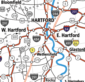
But Connecticut was the epicenter of NYNH&H's collapse. It had the rail monopoly in the state, was so bankrupt it couldn't repair any of its washouts from the 1955 hurricanes that shredded in-state movements, and the state couldn't do anything about it because that was all behind a federal paywall. So this is what the ConnDOT map started looking like when they were grasping at straws at an imminent future of total modal singularity. And the roads infamously don't work at all today because planning became contingent on most/all of those spurs being built in total hands-joining tandem to keep the spines above water. "Pull a Conrail 20 years early" definitely would've changed CT's trajectory to present, maybe to more unrecognizable degree than MA. But, alas, that's "Earth Three" alternate universes for you. . .
It's a fascinating read.
That document is a gold mine. The opening paragraph of page 96 says it all for me:
A comprehensive plan for improvement of the transit system is contained in the two reports by the Metropolitan Transit Recess Commission dated April 1945 and April 1947. It is assumed that this program, in essential the form and to the extend recommended, will be carried out. If rapid transit facilities are not extended and improved, the system of expressways recommended will be inadequate to handle the volumes of traffic that will be generated in the outer and rapidly growing portions of the metropolitan district.
Here's a link the Metropolitan Transit Recess Commission doc: https://archive.org/details/reportofmetropol00mass_1/page/14/mode/2up. Clearly the transit and highway plans were made to complement each other to some degree.
It has some nice recommendations such as (put in terms of current lines)
- Red Line to Lexington
- Underground stations at Harvard and Porter for bus transfers
- Green Line extension from Lechmere to North Woburn (27 mins from N. Woburn to Park Street!)
- Rapid Transit to Riverside via B&A
- Green Line to Needham
- Blue Line to Lynn
- Red Line to Waltham via Central MA ROW (20 min from Waltham to Harvard w/5 minute headways @ rush hour)
- Plus many, many more, including Beyond Braintree, Medford Square, Readville
- Rapid transit to Chelsea
- Rapid transit to Salem
- 14 mile circumferential subway loop (est. cost $91 million) through Everett, Malden, Medford, Somerville, Cambridge, and Boston
- Removal of elevated structures, alt. route from Sullivan to Forest Hills (needed more study)
- Rapid transit Point of Points w/connection to Saugus Ctr.
Fast-forward a few years and we got the D Line, Red Line to Harvard, removal of the El, and a half-built highway system. Ironic that highway and transit planners admitted that both were required to be built to meet traffic needs, and then we didn't do a full build of either. The result shouldn't have been a surprise.
Last edited:
DrFreewind
Active Member
- Joined
- Sep 22, 2016
- Messages
- 175
- Reaction score
- 356
lots of left lane entrances and exits on the highways around hartford from the unbuilt sections, which are awful. but it did bring some interesting stuff like the 4 stack interchange with half of the ramps unusedYou know...like this utterly insane Greater Hartford planning map from 1963 just screams "PANIC!" at the top of its lungs rather than represent something even anyone at the time thought could coherently function.
But Connecticut was the epicenter of NYNH&H's collapse. It had the rail monopoly in the state, was so bankrupt it couldn't repair any of its washouts from the 1955 hurricanes that shredded in-state movements, and the state couldn't do anything about it because that was all behind a federal paywall. So this is what the ConnDOT map started looking like when they were grasping at straws at an imminent future of total modal singularity. And the roads infamously don't work at all today because planning became contingent on most/all of those spurs being built in total hands-joining tandem to keep the spines above water. "Pull a Conrail 20 years early" definitely would've changed CT's trajectory to present, maybe to more unrecognizable degree than MA. But, alas, that's "Earth Three" alternate universes for you. . .
Charlie_mta
Senior Member
- Joined
- Jul 15, 2006
- Messages
- 5,150
- Reaction score
- 7,777
For whatever reason, Connecticut was huge into left-hand expressway exits and complex interchanges in the 60's and 70's. Unlike Massachusetts, which pretty much stayed with traditional cloverleaf interchanges.lots of left lane entrances and exits on the highways around hartford from the unbuilt sections, which are awful. but it did bring some interesting stuff like the 4 stack interchange with half of the ramps unused
Charlie_mta
Senior Member
- Joined
- Jul 15, 2006
- Messages
- 5,150
- Reaction score
- 7,777
Here's a link the Metropolitan Transit Recess Commission doc: https://archive.org/details/reportofmetropol00mass_1/page/14/mode/2up. Clearly the transit and highway plans were made to complement each other to some degree.
Fantastic. Thank you for the link. I hadn't seen this one. Amazing read.
I love this excerpt:

An opportunity lost. But maybe on the next Tobin Bridge?
Last edited:

Fantastic. Thank you for the link. I hadn't seen this one. Amazing read.
In one of the disregarded alternatives, which was a double deck structure along Atlantic Avenue, they note that the recently removed structure had improved property values and that adding a new one would certainly depress property values.
Finally, here's a doc containing summaries of many of the reports from each year: https://archives.lib.state.ma.us/bi...86874-1958-SB-0585.pdf?sequence=1&isAllowed=y
F-Line to Dudley
Senior Member
- Joined
- Nov 2, 2010
- Messages
- 9,970
- Reaction score
- 12,302
lots of left lane entrances and exits on the highways around hartford from the unbuilt sections, which are awful. but it did bring some interesting stuff like the 4 stack interchange with half of the ramps unused
Many of those unused left-lane exits were for this glut of never-built expressway connectors. Sission Ave. and Flatbush Ave. on I-84 and Whitehead Highway on I-91 in Hartford are three of the more infamous never-were connectors that were supposed to load-spread Interstate traffic around downtown.