Roads and Highways General Development Thread

Add a signal and slow down the traffic moving through here. Let's ground this "interchange" (it is really just a large intersection or at least should be), add a traffic signal and incorporate the pedestrian features AND car features at grade. This could eliminate the ramping and odd collector roads around the intersection as well as open up land that could be sold off by MassDOT (or at least ground leased). I would also be willing to bet that the land value would offset a good amount of the cost of grounding and rebuilding the intersection. This would also unlock approximately 7 acres of land for development!

I sometimes feel like a broken record here but: ....does the public support any of those ideas? An initial glance at the area and the history of this project + public opposition to prior concepts makes me rather skeptical.

Nearby single-family housing neighborhoods are usually unlikely to be happy with new development, especially of anything that isn't just another suburban strip-mall type operation - so I doubt "more acres of land for development" is a point in your favor.

Everyone that I've ever met hates the other signaled intersections along 9, and I'm not at all convinced that the average person thinks slowing down traffic on Route 9 even more/adding more of them would be a positive change.

This is a low-density suburban area + car-focused commercial strip with zero local transit besides a single low-frequency weekday-only bus on Route 9, to remind.

----------

I'm also not sure I'm convinced that you can get the current volume of traffic through a basic signalized intersection unless you're doing a lot of queue/merge lanes - the other signaled intersections look to have much lower traffic volumes on the cross-streets than Route 27 has, and thus likely can give Route 9 more of the cycle time than here would be able to. If there's traffic modeling to suggest otherwise, I'm open to hearing it, though.
 
Everyone that I've ever met hates the other signaled intersections along 9, and I'm not at all convinced that the average person thinks slowing down traffic on Route 9 even more/adding more of them would be a positive change.
I have spent years of my life at signaled intersections along route 9. i'm always okay without adding another.
 
This thread is largely full of people who have never been to the area and have somehow convinced themselves it's the next Seaport.
 
This thread is largely full of people who have never been to the area and have somehow convinced themselves it's the next Seaport.
I can understand that sentiment but major infrastructure like this is built for the next few decades, not for the next few years. This intersection is less than a mile from the Natick Center stop and if they ever have plans of converting route 9 from a highway into a mixed transit/bike/car boulevard in 2040, this redesign pretty much guarantees that won't happen.
 
I can understand that sentiment but major infrastructure like this is built for the next few decades, not for the next few years. This intersection is less than a mile from the Natick Center stop and if they ever have plans of converting route 9 from a highway into a mixed transit/bike/car boulevard in 2040, this redesign pretty much guarantees that won't happen.
I don't think there are any plans to do that on this segment.
 
Wow! Talk about a collasel waste of money. I love the dedicated path for people, but I feel like this is a vast waste of land and resources.
Here is a somewhat radical (to MassDOT at least) idea. The first signal going east is 1.16 miles away. The first signal going west is 1.4 miles. Add a signal and slow down the traffic moving through here. Let's ground this "interchange" (it is really just a large intersection or at least should be), add a traffic signal and incorporate the pedestrian features AND car features at grade. This could eliminate the ramping and odd collector roads around the intersection as well as open up land that could be sold off by MassDOT (or at least ground leased). I would also be willing to bet that the land value would offset a good amount of the cost of grounding and rebuilding the intersection. This would also unlock approximately 7 acres of land for development!
View attachment 53305
I am all for MassDOT getting on the DDI bandwagon (even the tough TDOT is embracing them here in TN), but lets do it at actual interstates and not state roads and Main Streets.
Any ideas how much it would cost to just change this to an intersection with a traffic light?

Part of the problem here is the plans are 40% over budget already. That article says total cost to MDOT is looking to be ~$118 million. It seems like we could save most of a hundred million dollars just turning this into a traffic light. That's a lot of money.

I understand that would diminish the road capacity. But for that kind of money, it's worth considering whether or not to take the hit on capacity, then spend that saved money on other modes of moving people and goods around.
 
There are already so many traffic signals along Route 9 between 495 and 95/128, adding one more is NOT going to hurt/kill anyone's commute. Let's look at the pros/cons of grounding as I showed....
  • Pros
    • Minimizes the amount of pedestrian/shared use conflict points
    • Eliminates ALL overpasses (over budget proposal shows THREE)
    • Unlocks up 7+ acres of land on a commercial corridor (probably wouldn't even need rezoning so public outcry is moot really)
    • Breaks up a 2.5 mile speedway along a road that has a TON of curb cuts and subsequent turning traffic
    • Saves millions of tax payer dollars
    • Brings in more sales tax for the state
    • Brings in more real estate taxes for Natick
  • Cons
    • Slight increase in commute times
    • Slight decrease in overall capacity (but not really?)
    • Slow down speed for car drivers
This isn't turning Natick/Route 9 into Seaport by any means. It create opportunities rather than limiting it for the slight benefit that those Cons represent.
 
Per MassDOT, the AADT of Rt. 9 through that intersection is about ~100k. 52EB and 48WB. Rt. 27 through that intersection has a bi-directional AADT of ~16k through the intersection.
 
Last edited:
adding one more is NOT going to hurt/kill anyone's commute
I mean this would be demolishing an existing overpass and dropping a traffic light in the middle of it. This will turn two Routes that currently do not have to come to a complete halt and making them wait for each other. All the other Route 9 lights pretty much give priority to Route 9 (which is a double edged sword, but does its best to keep congestion to a minimum). Route 9 will always continue to be a major artery into the city, and keeping it moving is probably a great idea.

What happens when Route 27 N is backed up because of people making a left hand turn to drive to the Natick Mall? I'm all for new development but this part of Natick is already strip mall heaven, and that's what people in the surrounding area travel to Natick for most of the time.
 
  • Like
Reactions: FK4
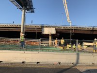
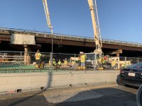
A couple of pics of Mystic Ave bridge near Sullivan Sq. getting its concrete pour yesterday.
A link to the rebar tying machine on rails they had on board for I think three days most? It was fairly quick once the rebar was laid.
Rebar tying machine
 

Attachments

  • IMG_5869.JPG
    IMG_5869.JPG
    4.1 MB · Views: 90
  • IMG_5880.JPG
    IMG_5880.JPG
    4.2 MB · Views: 90
  • IMG_5881.JPG
    IMG_5881.JPG
    4.1 MB · Views: 93
Last edited:
It looks like they're reconfiguring/restriping Roosevelt Circle in Medford. The way it's currently painted is pretty haphazard but they're now delineating lanes on the Fellsway northbound and trying to force Fellsway traffic to yield to off ramp traffic. They're also making the right lane from the southbound offramp and Fellsway leg exit only to South Border Road. In addition, the inner lane of the rotary has been coned off/removed in some places. Unfortunately, I can't seem to find any plans for how it's supposed to look in the final configuration.
 
It looks like they're reconfiguring/restriping Roosevelt Circle in Medford. The way it's currently painted is pretty haphazard but they're now delineating lanes on the Fellsway northbound and trying to force Fellsway traffic to yield to off ramp traffic. They're also making the right lane from the southbound offramp and Fellsway leg exit only to South Border Road. In addition, the inner lane of the rotary has been coned off/removed in some places. Unfortunately, I can't seem to find any plans for how it's supposed to look in the final configuration.
I *think* that's just prep for the Roosevelt Circle restoration work - (the bit that got hit by an oversized truck in 2021). it took them an age and a half to get around to it, but I believe it's MassDOT 612786.
 
Driving through Back Bay last night, Beacon Street was repaved from Arlington to Mass Ave! I don't think I've seen Beacon repaved in the past 30 years! Congratulations Boston. Now for my pecimism; I hope National Grid does nnot plan on replacing the gas main and every service line on Beacon for at least a year.
 
Last edited:
San Francisco has a 5-year moratorium on excavations in streets that have been repaved, reconstructed, or resurfaced. There are of course exceptions for leaks/emergencies and services to new buildings, but in general it does a decent job preventing streets (especially transit lanes) from turning into patchwork immediately.

 
San Francisco has a 5-year moratorium on excavations in streets that have been repaved, reconstructed, or resurfaced. There are of course exceptions for leaks/emergencies and services to new buildings, but in general it does a decent job preventing streets (especially transit lanes) from turning into patchwork immediately.

Driving through Back Bay last night, Beacon Street was repaved from Arlington to Mass Ave! I don't think I've seen Beacon repaved in the past 30 years! Congratulations Boston. Now for my pecimism; I hope National Grid does nnot plan on replacing the gas main and every service line on Beacon for at least a year.
I think they had Feeney already replacing the gas mains.
 
Does anyone know what's up with the highway signs on 128 in Burlington/Woburn stretch? At night, the reflectivity is chaotic; you can't read them. In daylight they appear normal.
 

Back
Top