Route 1 Project - Malden, Revere, Saugus

By the way, you mentioned someone with a business stake having something against this project. Why would they be against it? Looks like anyone abutting the area has the potential to buy more adjacent land. I can understand being against construction, but I'd think the outcome is worth it for them.

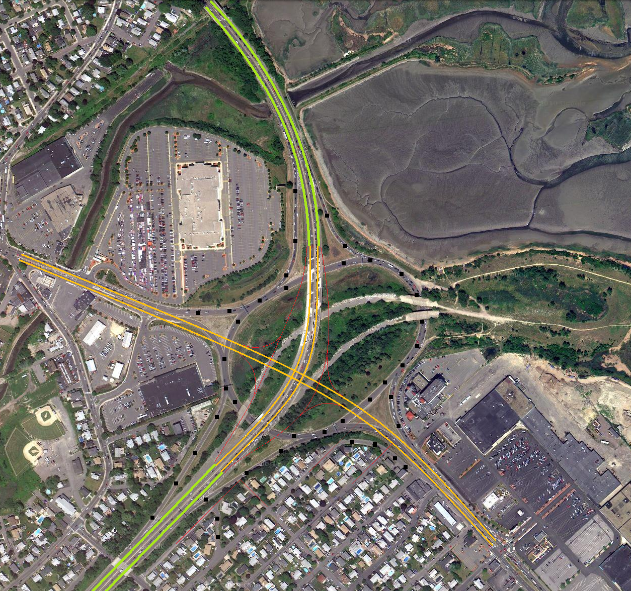
It's a function hall so impacting traffic patterns especeially when the rotary feeds his business directly would be a problem...
 
It looks to me like US 1 traffic goes over the rotary while MA 60 traffic goes through it ... which is the same thing that happens at I-93 and MA 60 near Medford Square. What am I confused about here?

The lanes for for Rt. 60 to Rt. 1 north/south are directly tied to the rotary, they are seperate from the rotary in Medford feeding in several hundred before the roary. You don't have to avoid the I93 traffic to get through the rotary in Medford like you have to get through it in Revere as that traffic is already separated before you hit the rotary.
 
The best (only) date I can find on those diagrams is 2010, and those were narrowed down from a bunch of other alternatives.


Anyways....

6071812120_792f8001da_o.png
 
6071337463_14f9a05133_o.png


This allows for a free flow of traffic in all directions without signals (all alternatives I saw containing the ability to go from 1N to 99S required a signal). This won't handle nearly as much traffic as Copeland Circle, so I think it's much better suiting to being a rotary. I think it would fit very nicely.
 
The best (only) date I can find on those diagrams is 2010, and those were narrowed down from a bunch of other alternatives.


Anyways....

6071812120_792f8001da_o.png

Renovations to improve/upgrade the Rt. 1 bridges rather than unneccessarily realligning them should be done. They aren't too bad, showing age but preventative maintnence in conjunction with the project should improve their lifespan.

Move the Rt. 60 west to Rt. 1 north connection farther back east, it comes up too abrupt in your design. Keep Rt. 1 norto to Rt. 60 east as is now, it is one of the only OK designs for the interchange. I might add another lane to Rt. 1 south at Rt. 60 to handle the interchange traffic to avoid the inevitable backups.
 
^ I changed 1N offramp because I was going to extend that paralleling street a ways (some of that is visible, connecting it back to Grove Street).

After doing a little looking at Diverging Diamond interchanges, I think it would handle traffic much better than what I dipicted.

large_diverging-diamond.gif


Essentially little to no backing up on the ramps.

The design I made for Rt 60 would work for Salem St (it's exactly the same idea I used for Salem St) but it's probably not so good here. I can definitely see it backing up all the way to the highway.


Does anyone at all have a map of what Copeland Circle and area was *supposed* to look like? I found something about a "Revere Beach Connector" which was supposed to meet I-95 right behind what is the North Gate Plaza and continue into Rt 1 North.
 
^ I changed 1N offramp because I was going to extend that paralleling street a ways (some of that is visible, connecting it back to Grove Street).

I am not so certain those streets need extending...if you want it done that way to move the offramp away from the houses then I can agree with that but otherwise I don't see the need to fix what isn't broken- I haven't seen any backing up at this offramp ever, it's probably the only part of the entire rotary/on and off ramps that actually works out well.


Does anyone at all have a map of what Copeland Circle and area was *supposed* to look like? I found something about a "Revere Beach Connector" which was supposed to meet I-95 right behind what is the North Gate Plaza and continue into Rt 1 North.

Is this what you mean? http://www.brorson.com/maps/BostonHighwayPlan_1965/BostonHighwayPlan_1965.jpg or this: http://www.bostonroads.com/roads/northeast/

The second one sounds like it's possibly what you are thinking of in the connection to Rt. 1A.
 
Last edited:
If 60 is "Revere Beach Connector" then it must be different. The impression I got was that another highway was going to meet I-95 at the NE corner of Copeland Circle.

(Which might explain that built up spit of land that appeared in the 70's next to the 107, just north of the new BJ's)


BTW, why is Copeland Circle being replaced before Bell Circle? Bell Circle is hideous, IMO. Absolute carmagedon every time I've been there.
 
If 60 is "Revere Beach Connector" then it must be different. The impression I got was that another highway was going to meet I-95 at the NE corner of Copeland Circle.

(Which might explain that built up spit of land that appeared in the 70's next to the 107, just north of the new BJ's).

Edited to include another link that may possibly explain your question...after you posted. See the aerial shot halfway down the page...I believe this is what you are talking about?

Also, this is interesting tangent...one of hte original routings shown with your segment shown: http://www.bostonroads.com/history/1948-map/

BTW, why is Copeland Circle being replaced before Bell Circle? Bell Circle is hideous, IMO. Absolute carmagedon every time I've been there.

Bell is bad, but it's really more of a stop light problem and doesn't have the backing up problems that Copeland has. It is bad, but not as bad.
 
Last edited:
Wait- here it is: http://www.bostonroads.com/roads/MA-60/

Somehow I opened that page before (purple link when accidentally found on Google) but I don't recall reading this.

This probably would have been the final nail in the coffin for Rumney Marsh, on top of the I-95 construction. The marsh has already been ravaged so badly... Just read up on some history, apparently from the Saugus River all the way down to Chelsea Creek was marsh. I've been looking at some of the 2010 imagery and the marsh seems to be dying in many places. I'm no expert, but when the grass is disappearing into dark-watered pools surrounded by dead brown grass, that's probably not good. Seems to happen in areas which are furthest from the waterways.
 
Wait- here it is: http://www.bostonroads.com/roads/MA-60/

Somehow I opened that page before (purple link when accidentally found on Google) but I don't recall reading this.

If you look closely at the 1948 map I linked to, this is on there. It's slightly out of whack with how it really was supposed to go(splits off before Rt. 60 interchange on map) but the connection to Brown Circle/Rt 107 and Rt. 1A/North Shore Road are visible. You found the verbal evidence to back up the mapping but puts it into perspective more.

This probably would have been the final nail in the coffin for Rumney Marsh, on top of the I-95 construction. The marsh has already been ravaged so badly... Just read up on some history, apparently from the Saugus River all the way down to Chelsea Creek was marsh.

Much of the eastern part of the city is reclaimed marshland but the central and western part of the city has always been solid land. A 1739 and a 1630 era map of the area...
http://www.olgp.net/chs/maps/map7.htm
http://www.olgp.net/chs/maps/map3.htm

Now if you had said Mill Creek/Chelsea Creak and Sales Creek/Belle Isle Marsh then yes you would be right as they connect to form the former islands of East Boston.

I've been looking at some of the 2010 imagery and the marsh seems to be dying in many places. I'm no expert, but when the grass is disappearing into dark-watered pools surrounded by dead brown grass, that's probably not good. Seems to happen in areas which are furthest from the waterways.

The damage had already been done long before the roadway construction, the mosquito abatement attempts in the early part of the last century especially in the 30s(CCC/WPA connected?) did the most and longest lasting damage to the marsh- long rows of lines in the marsh were manmade, it's the same in Mill Creek as well. While it would damage the ecosystem construction at least could have done something to compensate the loss of some land.

Regarding the browning- drought, fires(several in the last decade), and the fact that it is a tidal marsh play into the looks of the area. Add in that the time of year could be a factor as well. It could be a concern but I am not so sure at this point.
 
Hmm, that looks like it might be it. But it shows that somehow splitting off south of 60 instead of just north (wth?). But it goes all the way to North Shore Road, so...

But if it was what caused this: http://maps.google.com/maps?hl=en&ll=42.426114,-71.002321&spn=0.002685,0.005681&t=h&z=18&vpsrc=6 then perhaps that's it.

The large grassy strip of land right next to the road? I am not so sure that is part of the project- seems a bit odd htat they would reroute water around it, they would have simply put a tube for the water to flow through instead.

From the sound of the descriptions from the links they would have made Square Road closer to what 1A is like with Brown Circle, Bell Circle, and Butler Circle being improved to handle more traffic. I don't believe they would have used the marsh at all, as it wouldn't make sense to build when they had a major road already there that could be upgraded.
 
Digging at historicaerials.com I find the ramps are all graded.

6076444003_7467aa5ed5_b.jpg


To my best ability, this is what it looks like they were designing. A part of me is wishing this happened, simply to see the amazing interchange that would have taken place, but undoubtedly it would have been very destructive to so many areas. And I forgot to include the land sticking off of 107 (which doesn't appeared in 1969 along with most of the sand brought in (however, it appears little if any sand was brought in between 69 and 71 but all the grading was done during this time). If I extend those red lines, they'll run right into that spit of land.
 
Digging at historicaerials.com I find the ramps are all graded.

To my best ability, this is what it looks like they were designing. A part of me is wishing this happened, simply to see the amazing interchange that would have taken place, but undoubtedly it would have been very destructive to so many areas.

Remember that it was to be built on top of the old airport- the destruction had already been done years before. The biggest impact from the Rt. 60 highway would be between Rts. 107 and 1A.

And I forgot to include the land sticking off of 107 (which doesn't appeared in 1969 along with most of the sand brought in (however, it appears little if any sand was brought in between 69 and 71 but all the grading was done during this time). If I extend those red lines, they'll run right into that spit of land.

It is there in '69, but not there in '55. They line up exact if you zoom out far enough to prove you right on your assumption.
 
seems to me like a stoplight would cause more backups. Traffic merging into a rotary never needs to stop at all. The rotary at Route 60 and I-93 is identical in structure to this one, and I don't know of any plans to replace it.

This is incorrect. When there is a high volume of eastbound traffic on 60 and southbound traffic on Rt 1, the result is an absolute nightmare. You have to stop exiting Rt 1 to enter the rotary as the volume is high and there are few openings. The traffic queues up onto the offramp into the 2-lane section of Rt 1 back to lynn/salem St. Rt 1 south ends up effectively being 1 lane south at this point.

When they fix this, the light will put gaps in the 60 traffic keeping the ramp from backing up, and Rt1 will be widened to 3 lanes each way for its full length
 
Are they actually going ahead with this project? My sister who works for one of the businesses along route 1 heard the plan had been discarded. The reason, it would be too disruptive to many of the businesses along the road. In particular widening the road to six lanes would encroach on many of the businesses.
 
there really arent any businesses alon the 4 lane stretch other than Kappys
 
A quick tour down that area of route one via Google Street View shows plenty of smaller businesses such as gas stations, restaurants, etc. And then there's Lowe's.
 

Back
Top