cybah
Active Member
- Joined
- Feb 24, 2012
- Messages
- 278
- Reaction score
- 1
Silver Line Gateway (Photos!)
Silver Line Gateway Progress Photos
Hi Folks,
It's been a while since I've been on here, but I was urged by another ArchBoston user to post my pictures of the Silver Line Gateway project thru Chelsea here, as some of you may enjoy them! I'll apologize if there's an existing thread but I scanned a few pages and didn't see anything so I figured I'd start a new one (and keep all the construction photos in one place!)
On Saturday (4/25/15) I walked the entire route of the new BRT route and took pictures of the current construction. I started at Airport Station and walked to Market Basket in Chelsea, zig zagging my way across city streets to view the old ROW and future busway. It was a fairly long walk, and not really near any public transportation (except the irregular 112 bus) unless I was near Broadway and/or Washington Ave in downtown Chelsea, so the new BRT route will serve a very under-served area.
I took a TON of photos (300 in all), and paired it down to about 83. The full set can be seen here on Flickr, but I'll share some of the highlights below.
My main point of taking pictures was to document what the area looked like before all the work has substantially started, and then come back every month or so and take progress photos (and yes, I will post them here also). MassDOT has an aggressive construction timeline (service possibly by late 2017!) for this project so I anticipate lots of progress to happen between sets!
I'm also personally excited about this because I live close enough to monitor the progress, plus this was the first transit project I've been apart of (I went to almost all the meetings at city hall), and I had alot of input to give. This project is really going to change the face of Chelsea, and give us some additional transit service that we so desperately need and want. (Remember Chelsea has 3 out of the 15 "Key" Bus Routes!)
Yes it's not a LRV or an branch of the Blue Line, but it's something. Most of the buses thru Chelsea are jammed packed almost all hours of the day, and many, like the 111, run at frequencies of 5 minutes or less so adding more buses on city streets isn't going to help. We need something different and can be built fast with small money. And that's where this project comes in, MassDOT already owns the land and little to no modification to the commuter rail helps keep the costs of this project down. Plus it's fully backed by the state & federal gov't and the community in general, so there's very little NIMBY about this project at all, since it is well know that Chelsea needs more direct transit service. As a bus rider myself, I can attest that this will help greatly. It really is a win win for everyone.
For those of you who aren't familiar with the project, the Silver Line Gateway project is a new BRT line that will serve from South Station to the Mystic Mall (aka Market Basket) in Chelsea. It will serve all the stations in South Boston and use the Ted Williams Tunnel. However, unlike the SL1, it will bypass Logan Airport entirely and head to Airport Blue Line Station. After it leaves Airport Station, the buses will travel down the airport access road to the Martin A Coughlin Bypass Road (aka the East Boston Bypass Road) to connect to Chelsea Street. Once on Chelsea Street, the buses will cross the Chelsea Street Bridge, and cross the intersection of Central and Eastern and enter the Massport Garage's bus loop to join the new busway.
Once in the new busway, it will serve a stop at the Massport Garage called Eastern Avenue Station. Then the bus will continue up the new busway at an 'at grade' crossing at Cottage Street, and then go under the Bellingham Street bridge. It will then continue to Box District Station at the end of Highland Ave. Once leaving Box District station, it will join the Rockport Commuter Rail line under Broadway and Washington Ave to the current commuter rail station. This station will be reworked to be a BRT only station called Downtown Chelsea Station, while the commuter rail station will move behind Market Basket. Once it leaves Downtown Chelsea Station the buses will continue down along side the commuter rail to Market Basket with (signaled!) crossings at Arlington St, Spruce St, and Everett Ave. Once the buses cross Everett Ave they will enter Mystic Mall station and use the loop to around to become inbound buses again.
There are four main spotlights of this project:
The first is a new busway with four new stations entirely in Chelsea that will run from the MassPort Garage (near Central Ave @ Eastern Ave) to next Market Basket on Everett Ave.
The second spotlight is the relocation of the commuter rail station from it's current location on Sixth Street @ Arlington to behind Market Basket. This will allow for the station to receive much longer and high level, ADA-compliant, platforms and canopy's than it's current location.
The third is the Shared Use Path dubbed "The Chelsea Greenway" which will run from Eastern Ave Station to Chestnut Street (near Washington Ave).
The fourth is the rebuilding of the Washington Ave bridge to accommodate the new busway, however this bridge was deemed structurally obsolete, so it was slated to be replaced anyways.
More information about the project can be found here.
Last meeting presentation (August 2014) can be found here.
SEIR filing can be found here (a LOOONG read).
As far as the current status of construction, as you'll see below.. not much. However, construction only started two weeks ago, and it's pretty amazing (to me) how much they have cleared out already considering how much trash and brush is gone already from the old ROW. I'm sure when I head back to take more pics in a few weeks, I'll have some decent progress photos by then.
(and again, you can find the full set of photos here which paints an even better picture than below!)
------------------
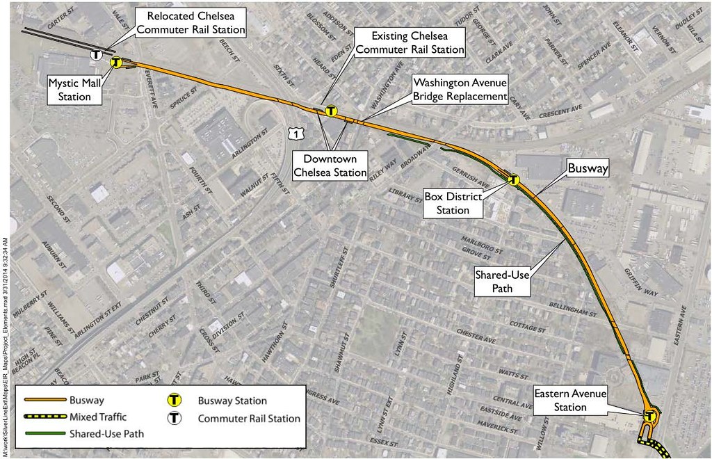
Here's a map of the future busway and station assignments:
------------------
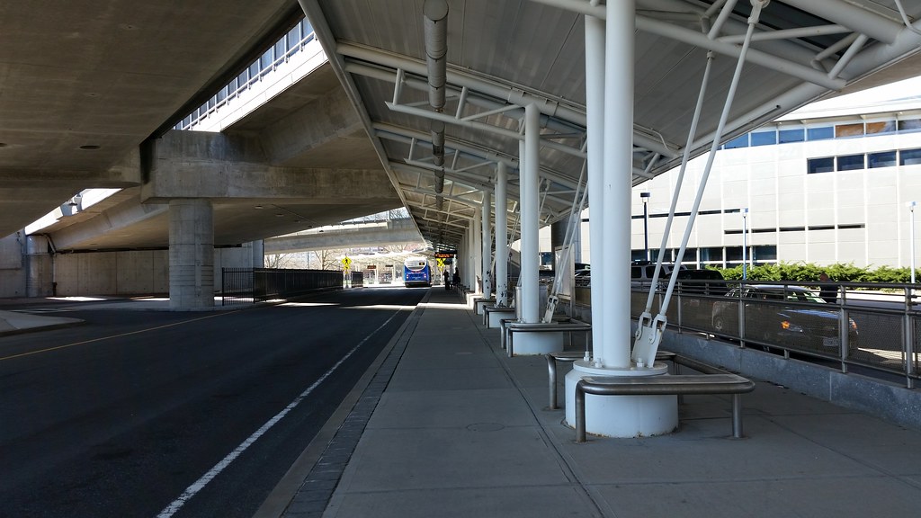
Here's the un-used waiting area at Airport Station that will become the platform for the new BRT route. I'm standing right at the end of the end of the outbound platform. MassDOT plans on adding real time tracking billboard (that will also notify riders when the Chelsea Street Bridge is going up!), better seating, shelters, and other amenities. (Click here to see the platform rendering)
------------------
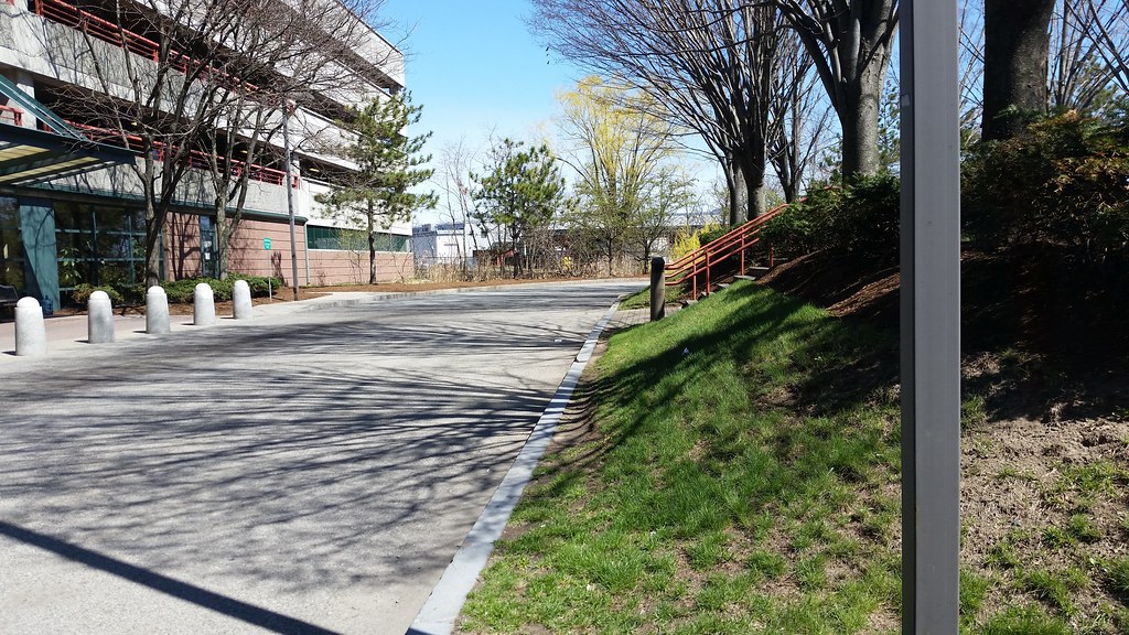
This is where Eastern Ave Station will be next to the Massport Garage near Central Ave @ Eastern Ave. The Inbound platform will be right where the pine tree straight ahead is. Then beyond that will be the entrance to the future busway. (Click here to see the platform rendering)
------------------
Here's a view looking up the future busway from Cottage Street (at grade) crossing to the Bellingham Street bridge. You can really gauge how wide the new busway and shared use path really will be. This is also where most of the 'noticable' construction is (outside of trash/brush removal).
------------------
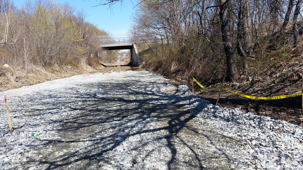
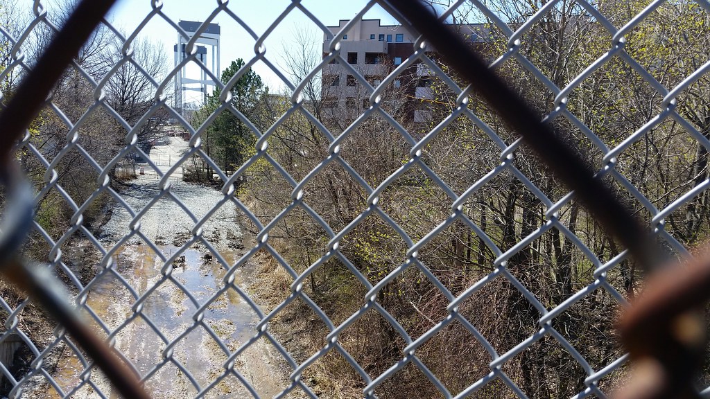
Here's a view from the Bellingham Street bridge of the future busway looking south (toward the new Eastern Ave Station). Yes that's water. There's a tiny wetland here that has to be contended with there before the busway can go in. (the SEIR doc has more details about this)
------------------
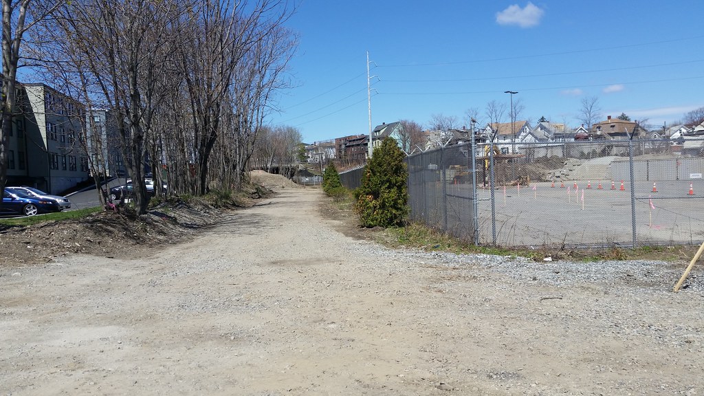
This is where Box District Station will be. The trees on the left will remain and will be joined just to the right by the Shared Use Path. The inbound platform will be about where the gravel/cleared area is (near the 2d clump of thick trees). The outbound side should be somewhere near those pink stakes (on the otherside of the fence). (Click here and here to see the station layout renderings)
------------------
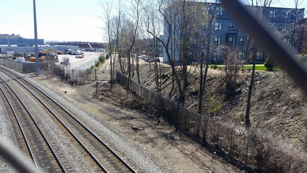
Here's the junction with the Rockport Commuter Rail line, as seen from the Broadway bridge. The future busway will come out about where those gates are, stay to the right of the CR line and go under the bridge (with a signaled one-way). That entire (gross) mound will be re-worked, and a retaining wall installed to support the shared use path that will run at the top (and connect to Broadway on the otherside of the bridge). In short, it's going to look a heck of a lot better than it is now!
------------------
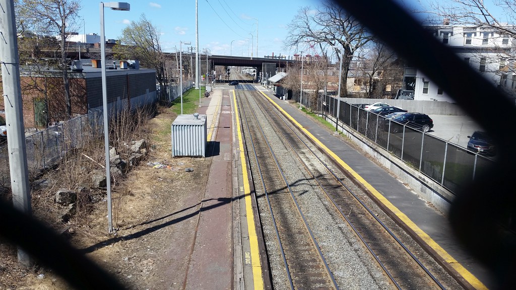
This is a view of the current Chelsea Commuter Rail Station. When the CR station gets moved behind Market Basket, this will be remodeled to be a BRT only station. The inbound platform will be in the lower left hand corner of the picture (where the 1st utility pole is) with a connecting ramp to Washington Ave. The outbound platform will be close to the Arlington/Sixth intersection on top of the old railroad tracks (which will be removed). The future busway will snake between the two. (Click here to see the station layout renderings)
------------------
Here's a view looking down the future busway between Everett Ave and the existing CR station. (Everett Ave and Market Basket are behind me). MGH Chelsea is to the right, and the new FBI building is to the left. Plenty of room for the future busway!

-------------------
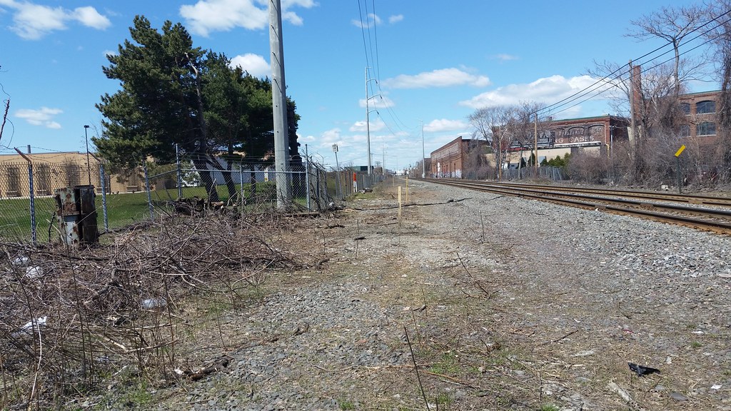
This is where the future Mystic Mall and CR station will be. The new return loop will circle the group of pine trees on the left with the outbound stop being about where those stakes are, and the inbound being the mound of grass on the left. The new CR station platforms should start at the 3rd stake (in the distance) (Click here to see the station layout renderings)
And for more photos or more of a step by step walk thru, you can click here to see the full set.
-----
I think that's it for now. I will take more pictures in the near future, and post here as construction start to ramp up. I'll also try to answer any questions as best as possible if people have any!
Thanks, Kris (aka cybah)
PS - Mods, if my picture are too big/large/small/broken or I didn't do this right, PM me.. happy to fix.
Silver Line Gateway Progress Photos
Hi Folks,
It's been a while since I've been on here, but I was urged by another ArchBoston user to post my pictures of the Silver Line Gateway project thru Chelsea here, as some of you may enjoy them! I'll apologize if there's an existing thread but I scanned a few pages and didn't see anything so I figured I'd start a new one (and keep all the construction photos in one place!)
On Saturday (4/25/15) I walked the entire route of the new BRT route and took pictures of the current construction. I started at Airport Station and walked to Market Basket in Chelsea, zig zagging my way across city streets to view the old ROW and future busway. It was a fairly long walk, and not really near any public transportation (except the irregular 112 bus) unless I was near Broadway and/or Washington Ave in downtown Chelsea, so the new BRT route will serve a very under-served area.
I took a TON of photos (300 in all), and paired it down to about 83. The full set can be seen here on Flickr, but I'll share some of the highlights below.
My main point of taking pictures was to document what the area looked like before all the work has substantially started, and then come back every month or so and take progress photos (and yes, I will post them here also). MassDOT has an aggressive construction timeline (service possibly by late 2017!) for this project so I anticipate lots of progress to happen between sets!
I'm also personally excited about this because I live close enough to monitor the progress, plus this was the first transit project I've been apart of (I went to almost all the meetings at city hall), and I had alot of input to give. This project is really going to change the face of Chelsea, and give us some additional transit service that we so desperately need and want. (Remember Chelsea has 3 out of the 15 "Key" Bus Routes!)
Yes it's not a LRV or an branch of the Blue Line, but it's something. Most of the buses thru Chelsea are jammed packed almost all hours of the day, and many, like the 111, run at frequencies of 5 minutes or less so adding more buses on city streets isn't going to help. We need something different and can be built fast with small money. And that's where this project comes in, MassDOT already owns the land and little to no modification to the commuter rail helps keep the costs of this project down. Plus it's fully backed by the state & federal gov't and the community in general, so there's very little NIMBY about this project at all, since it is well know that Chelsea needs more direct transit service. As a bus rider myself, I can attest that this will help greatly. It really is a win win for everyone.
For those of you who aren't familiar with the project, the Silver Line Gateway project is a new BRT line that will serve from South Station to the Mystic Mall (aka Market Basket) in Chelsea. It will serve all the stations in South Boston and use the Ted Williams Tunnel. However, unlike the SL1, it will bypass Logan Airport entirely and head to Airport Blue Line Station. After it leaves Airport Station, the buses will travel down the airport access road to the Martin A Coughlin Bypass Road (aka the East Boston Bypass Road) to connect to Chelsea Street. Once on Chelsea Street, the buses will cross the Chelsea Street Bridge, and cross the intersection of Central and Eastern and enter the Massport Garage's bus loop to join the new busway.
Once in the new busway, it will serve a stop at the Massport Garage called Eastern Avenue Station. Then the bus will continue up the new busway at an 'at grade' crossing at Cottage Street, and then go under the Bellingham Street bridge. It will then continue to Box District Station at the end of Highland Ave. Once leaving Box District station, it will join the Rockport Commuter Rail line under Broadway and Washington Ave to the current commuter rail station. This station will be reworked to be a BRT only station called Downtown Chelsea Station, while the commuter rail station will move behind Market Basket. Once it leaves Downtown Chelsea Station the buses will continue down along side the commuter rail to Market Basket with (signaled!) crossings at Arlington St, Spruce St, and Everett Ave. Once the buses cross Everett Ave they will enter Mystic Mall station and use the loop to around to become inbound buses again.
There are four main spotlights of this project:
The first is a new busway with four new stations entirely in Chelsea that will run from the MassPort Garage (near Central Ave @ Eastern Ave) to next Market Basket on Everett Ave.
The second spotlight is the relocation of the commuter rail station from it's current location on Sixth Street @ Arlington to behind Market Basket. This will allow for the station to receive much longer and high level, ADA-compliant, platforms and canopy's than it's current location.
The third is the Shared Use Path dubbed "The Chelsea Greenway" which will run from Eastern Ave Station to Chestnut Street (near Washington Ave).
The fourth is the rebuilding of the Washington Ave bridge to accommodate the new busway, however this bridge was deemed structurally obsolete, so it was slated to be replaced anyways.
More information about the project can be found here.
Last meeting presentation (August 2014) can be found here.
SEIR filing can be found here (a LOOONG read).
As far as the current status of construction, as you'll see below.. not much. However, construction only started two weeks ago, and it's pretty amazing (to me) how much they have cleared out already considering how much trash and brush is gone already from the old ROW. I'm sure when I head back to take more pics in a few weeks, I'll have some decent progress photos by then.
(and again, you can find the full set of photos here which paints an even better picture than below!)
------------------
Here's a map of the future busway and station assignments:

------------------
Here's the un-used waiting area at Airport Station that will become the platform for the new BRT route. I'm standing right at the end of the end of the outbound platform. MassDOT plans on adding real time tracking billboard (that will also notify riders when the Chelsea Street Bridge is going up!), better seating, shelters, and other amenities. (Click here to see the platform rendering)

------------------
This is where Eastern Ave Station will be next to the Massport Garage near Central Ave @ Eastern Ave. The Inbound platform will be right where the pine tree straight ahead is. Then beyond that will be the entrance to the future busway. (Click here to see the platform rendering)

------------------
Here's a view looking up the future busway from Cottage Street (at grade) crossing to the Bellingham Street bridge. You can really gauge how wide the new busway and shared use path really will be. This is also where most of the 'noticable' construction is (outside of trash/brush removal).

------------------
Here's a view from the Bellingham Street bridge of the future busway looking south (toward the new Eastern Ave Station). Yes that's water. There's a tiny wetland here that has to be contended with there before the busway can go in. (the SEIR doc has more details about this)

------------------
This is where Box District Station will be. The trees on the left will remain and will be joined just to the right by the Shared Use Path. The inbound platform will be about where the gravel/cleared area is (near the 2d clump of thick trees). The outbound side should be somewhere near those pink stakes (on the otherside of the fence). (Click here and here to see the station layout renderings)

------------------
Here's the junction with the Rockport Commuter Rail line, as seen from the Broadway bridge. The future busway will come out about where those gates are, stay to the right of the CR line and go under the bridge (with a signaled one-way). That entire (gross) mound will be re-worked, and a retaining wall installed to support the shared use path that will run at the top (and connect to Broadway on the otherside of the bridge). In short, it's going to look a heck of a lot better than it is now!

------------------
This is a view of the current Chelsea Commuter Rail Station. When the CR station gets moved behind Market Basket, this will be remodeled to be a BRT only station. The inbound platform will be in the lower left hand corner of the picture (where the 1st utility pole is) with a connecting ramp to Washington Ave. The outbound platform will be close to the Arlington/Sixth intersection on top of the old railroad tracks (which will be removed). The future busway will snake between the two. (Click here to see the station layout renderings)

------------------
Here's a view looking down the future busway between Everett Ave and the existing CR station. (Everett Ave and Market Basket are behind me). MGH Chelsea is to the right, and the new FBI building is to the left. Plenty of room for the future busway!

-------------------
This is where the future Mystic Mall and CR station will be. The new return loop will circle the group of pine trees on the left with the outbound stop being about where those stakes are, and the inbound being the mound of grass on the left. The new CR station platforms should start at the 3rd stake (in the distance) (Click here to see the station layout renderings)

And for more photos or more of a step by step walk thru, you can click here to see the full set.
-----
I think that's it for now. I will take more pictures in the near future, and post here as construction start to ramp up. I'll also try to answer any questions as best as possible if people have any!
Thanks, Kris (aka cybah)
PS - Mods, if my picture are too big/large/small/broken or I didn't do this right, PM me.. happy to fix.
Last edited:


