Silver Line to Chelsea

Re: Silver Line to Chelsea (Study Meeting)

Thanks. I don't expect it to be an issue but if the green line ever does reach to chelsea which I wouldn't expect for a long time then I think it will need to change.
 
Re: Silver Line to Chelsea (Study Meeting)

Thanks. I don't expect it to be an issue but if the green line ever does reach to chelsea which I wouldn't expect for a long time then I think it will need to change.

Yeah if its ever converted to Light Rail, many changes will have to get done including that bridge.

More importantly a switch to Light Rail would require major work (or a new crossing) at the Chelsea Street Bridge.
 
Re: Silver Line to Chelsea (Study Meeting)

I didnt realize work had already started on this - when's it supposed to be completed?
 
Re: Silver Line to Chelsea (Study Meeting)

I didnt realize work had already started on this - when's it supposed to be completed?

Depends on the phase, but should be completed with service by 2017.

Phase 1 has started, which is the busway, Eastern Ave, Box District, and Mystic Mall Stations and the reconstruction of the Washington Ave Bridge.

Phase 2 which will start once Phase 1 is mostly done, will be moving the Commuter Rail Station to behind the mall, and remodeling the current CR station to be a BRT station.

I think (and I'm guessing without looking at the docs online) service should open by 2017 even without DT Chelsea Station being opened.

I anticipate that by late fall much of the busway will be done already and work on the stations to be started before snow sets in. So it's going to move very quickly.
 
Re: Silver Line to Chelsea (Study Meeting)

I think datadyne007 asked about a bus lane thru Chelsea for the 111/116/117 buses.

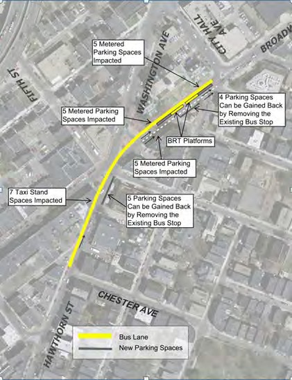
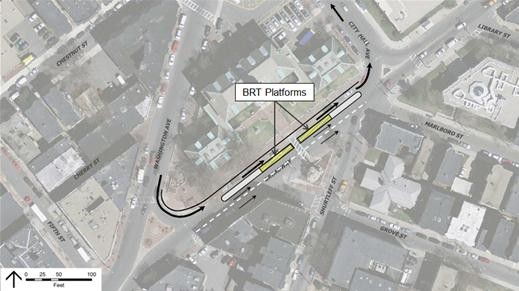
Originally moving the bus stop in front of BHCC to in front of city hall on Broadway was one of the ideas for this project to be included with the project, but never made it back out of the design phase and was just removed. This would have moved the BHCC stop and combined it with the Shurtleff Street stop. It would have also provided easier transfers to the SLG busway (via the Shared Path entrance on B'way)

I think it was cut because of costs, but anothe reason was that a few residents of neighboring buildings (near the end of Shurtleff and Library) complained that the current stop in front of BHCC is a haven for homeless and riff raff and they didn't want that in front of their houses. So it was axed.

The current location of the stop is kinda meh.. I do wish there was a buslane instead. Maybe it can be brought up again to re-think about doing this, although I think it would be a separate project vs included with the SLG project.

But there was a diagram of it.. see below.

17322638021_3b959f0c91_o.jpg


Edit: Found an even closer shot of the platform layout

17323121235_8d74f23d70_o.jpg


(boy I am just active today on here.... now ask me how much work I've done today.. LOL)
 
Re: Silver Line to Chelsea (Study Meeting)

haha while it's a cute name.. the building is actually being torn down (story) to make way for this complex. And the complex isn't next to the station, it's about a block or so away (closer to the Hess and CHS)

And yes I know people on here like to take pot shots, it just gets annoying sometimes but for the good of the forum and spreading correct information, I'm here and I'll live with it.

cybah -- sounds a bit like the Chelsea version of Cordage Park in Plymouth -- most of the original building has been demolished but the name has been left
 
Re: Silver Line to Chelsea (Study Meeting)

Yeah if its ever converted to Light Rail, many changes will have to get done including that bridge.

More importantly a switch to Light Rail would require major work (or a new crossing) at the Chelsea Street Bridge.

Not really. Amtrak and many light rail systems worldwide have lift bridges of similar design that detach the overhead wires during opening. Lifts are actually the best for that because they move faster than any other movable bridge type and the wires stay level on-alignment unlike bascules where the have to fold. Rest of the modification is just rails-in-pavement and timing the signal cycles so the LRV's can slip on/off the street (or grass) quickly and inocuously on either side of the bridge. And scheduling wouldn't be an issue because the openings get scheduled so far in advance dispatch would have >an hour to plan to throttle headways around the opening. It's such a short distance there wouldn't be much need for a parallel span, since that would have to be a movable bridge too.

That's really going to be a rounding error on the total expenses involved in an LRT conversion. So will the new-construction busway. Bigger costs for conversion on the actual SL Gateway footprint will be:

1) Widening out the Haul Road embankment to the original 4-track RR ROW's retaining walls around the street overpasses where it was filled in, in order to get the trolley reservation.

2) The electrical substations, trunk feeder off the Blue Line at Airport, and substation upgrades in/around Blue for feeding the feeder.


Then of course all the all-new construction cost for the Mystic Bridge, the electrical feeders and Orange tie-in substation boosts from that side, switching sides of the Eastern Route ROW around the Everett Terminal freight turnout, completing the necessary grade separation all but 6th/Arlington (if it hasn't been done previously), and just generally completing the circuit so the trolleys can get there in the first place. I could even see it working as tracks-in-pavement on the busway-proper so both modes share an overlap between Logan and the Mall. Nothing at all technically difficult about that the way this is being designed today. Haul Road's probably the only place it needs a separate reservation since the trucks share the pavement on that brief stretch. Anywhere it's just bus and trolley they can coexist just spiffy at the same platforms.
 
Re: Silver Line to Chelsea (Study Meeting)

Not really. <snip>

platforms.

I agree with the Chelsea Street Bridge idea that you give, because yes you're right but this is the T we're talking about, and to run rails in an existing roadway seems unlikely (because we know how much the T loves running in-street rails a la E line.. /s ) but you never know.

And yes rail and buses (electric) can co-exist on the same 'track' (for lack of a better word). It's done elsewhere.. SF and Seattle being two systems that do this.
 
Last edited:
Re: Silver Line to Chelsea (Study Meeting)

I like your post but a couple of things

I agree with the Chelsea Street Bridge idea that you give, because yes you're right but this is the T we're talking about, and to run rails in an existing roadway seems unlikely (because we know how much the T loves running in-street rails a la E line.. /s ).

And yes rail and buses (electric) can co-exist on the same 'track' (for lack of a better word). It's done elsewhere.. SF and Seattle being one.

Well, the difference here is that you probably can't get tall enough between the Curtis St. underpass and the river to do a fixed span (that would be a real barf bag of a steep incline to pack into 600 ft. of running space). So being consigned to a movable span any which way forces them to look outside their institutional bubble some way or another. Way I figure it:

-- Eastie side the trains pull up on the grass. Signal installed for slipping onto the bridge. Works for the traffic queues because it would be a short cycle well-spaced from the next signal either direction.

-- Chelsea side slightly more complicated. Ride the full length in mixed traffic to the intersection, E-style. Intersection somewhat reconfigured so the center median is wider and trolleys stay left of a fat (i.e. diagonal-striped) yellow line around that median so they can pull up to the front and bypass the car queue. Width at the intersection is completely adequate to widen out while keeping the same lanes and same permissive right-turns from Eastern Ave. NB and Chelsea St. WB. Eastern Ave. SB stop line moved back a few feet so the trolleys can cross on/off the ROW unobstructed. 1000 total feet of street-running. Clean on signaling because you'd just insert a very short cycle at the intersection just long enough to clear the trolleys. Spacing from the trolley turnout signal on the Eastie side more than wide enough that queues wouldn't back up (and that signal's also extremely short, just long enough to slip the trolleys on/off.


I could possibly see some other scenarios where the trolleys turn out on the grass the second they hit land on the Chelsea side to shorten the amount of street-running by a third, but that would be messier for signaling and I don't have that clear concept of how it would work. My thinking is just keep it simple as above because this is a shorter distance to travel around car traffic than the B already does between the Carlton St. light and BU West through that MUCH more chaotic BU Bridge intersection where even though it's on a proper reservation the car queues crossing from Mountfort routinely block the tracks. Chelsea St. is way more orderly than that the way it's spaced and processes its traffic, despite the volumes.

So if this exceeds the traffic management cleanliness of that BU Bridge cluster@#$% (and it does, handily) and the rail line has total grade separation everywhere else (and it does, except for that least-concern 6th/Arlington un-eliminable)...I think we have a winner that doesn't require a parallel bridge.


(We'll be waiting an awfully long time for it to happen, but it works without complications.)
 
Well, the difference here is that you probably can't get tall enough between the Curtis St. underpass and the river to do a fixed span (that would be a real barf bag of a steep incline to pack into 600 ft. of running space). So being consigned to a movable span any which way forces them to look outside their institutional bubble some way or another. Way I figure it:

-- Eastie side the trains pull up on the grass. Signal installed for slipping onto the bridge. Works for the traffic queues because it would be a short cycle well-spaced from the next signal either direction.

OK! you've sold me. Only because one thing that I failed to remember that the issue with the Chelsea Creek are the ships themselves, so the tunnel would need to be very deep under the creek, OR we're stuck with another drawbridge right next to the the current bridge because trying to build a super high overpass would just not be possible, so you're stuck with a drawbridge. And it makes no sense to build a second bridge when you have a perfectly good one next to it (and would also be going up at the same time), it's just silly.

So yes, just going onto the current bridge in mixed traffic really is makes better sense. (and probably most economic sense also)

-- Chelsea side slightly more complicated. Ride the full length in mixed traffic to the intersection, E-style. Intersection somewhat reconfigured so the center median is wider and trolleys stay left of a fat (i.e. diagonal-striped) yellow line around that median so they can pull up to the front and bypass the car queue. Width at the intersection is completely adequate to widen out while keeping the same lanes and same permissive right-turns from Eastern Ave. NB and Chelsea St. WB. Eastern Ave. SB stop line moved back a few feet so the trolleys can cross on/off the ROW unobstructed. 1000 total feet of street-running. Clean on signaling because you'd just insert a very short cycle at the intersection just long enough to clear the trolleys. Spacing from the trolley turnout signal on the Eastie side more than wide enough that queues wouldn't back up (and that signal's also extremely short, just long enough to slip the trolleys on/off.


Yes something like that. I was trying to do a diagram but it's complicated. Because you *could* do a turn out just after the bridge in the ROW (that is currently a empty lot) so the LVRs hit the ROW head on (and have a waiting area for the light and might help with signalling issues), but like you said it could also turn into a signaling mess.

And then of course going directly thru the intersection has its own issues with the islands and existing traffic patterns. It would be one mess of an intersection thou.


(We'll be waiting an awfully long time for it to happen, but it works without complications.)

A very very very long time.

But not for nothing, I think the busway should serve fine for many years, if managed properly. Yes it's a bus, but it's in its own ROW, so it will move along.

I just want it to go to Wellington!
 
How does the new haul road/busway connect across the Blue Line tracks and 1A to the Airport loop road? Haven't been able to figure out the tie in.
 
How does the new haul road/busway connect across the Blue Line tracks and 1A to the Airport loop road? Haven't been able to figure out the tie in.

It connects to the Surface Rd (that's the name) which runs to the airport and connects to the Ted Williams Tunnel. (Map) There are a lot of looping roads and overpasses throughout the airport so it's hard to see but it's there.


Edit: Unrelated to anything check out where they test the asphalt painters at Loagn.

The BL goes under the entrance to the bypass road in Eastie and exits after.

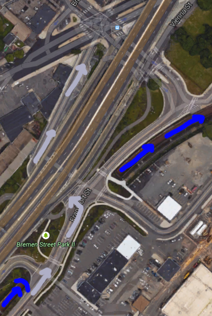
Here.. this will help. Blue arrows are Blue Line, Grey/pink arrows are the new Silver Line Gateway (SL6) buses. The big highway thing is 1A.

The buses will go down the Access Road, make a left onto the bypass road going under 1A (and over the BL tunnel), then continue to the bypass road to Chelsea Street and beyond.

17138487708_0536fd83d9_o.jpg


The crossing was always there, which is why the bypass road was a no brainer since no crossing has to be dealt with.
 
Sounds great except that the Chelsea Street bridge takes 30 minutes to go up and down, so the schedule will never be reliable.
 
Sounds great except that the Chelsea Street bridge takes 30 minutes to go up and down, so the schedule will never be reliable.

MassDOT said they were going to try to get alerts out earlier than usual. It's not like it's going up and down all day long, anyway.
 
MassDOT said they were going to try to get alerts out earlier than usual. It's not like it's going up and down all day long, anyway.

No, just during the morning and evening rush hour. Nbd.

On a serious note: Airport is supposed to have an alert at the stop saying if the bridge is up. MassDOT still has no Twitter alerts for the bridge, like they do with the Fore River Bridge.
 
Thanks Cybah, that makes sense.

gooseberry; presumably the T would be notified well in advance of any bridge activity, adjust headways accordingly, and put out updates to riders via social media and station announcements.
 
Anyone have any idea what the travel time from downtown Chelsea to South Station will be during peak as well as off-peak hours? I actually don't have much of a sense of how bad the Ted is during rush hour...
 
I'm sure this was covered somewhere but what are the ridership projections between Chelsea and Airport and Airport and South Station? I'm assuming more people will get off at Airport than ride to SBW but that will grow once the service takes hold and the SBW builds out.
 

Back
Top