Transit history/trivia quiz

I scoured the net and found this aerial photo of the old elevated track layout at North Station, showing how the Atlantic Avenue El stub-ended at the raised platform alongside the Green Line at the GL North Station:

aerial2.jpg
 
The high platform at the east end of the old Green Line el station (at North Station) was the stub northern end of the Atlantic Avenue elevated line, which was part of what is today called the Orange Line. The elevated line began as a single stub track alongside this high platform at North Station (with pedestrian access to North Station), then shared the OL elevated line along Causeway Street, then branched off at Commercial Street, continuing on Atlantic Ave (as a double track elevated) to South Station, then continuing further south to tie back into the OL elevated mainline at Washington Street, about where the Mass Pike is now.

Fascinating, I hadn't even realized the shuttle platform had ever been there. Apparently the shuttle trains stopped on the far side of the platform (closer to North Station than the trolley in the video Riverside linked). Anyone know if there was a passageway below the shuttle platform, or did you have to go via that platform to get to the connector to the Garden?
 
Fascinating, I hadn't even realized the shuttle platform had ever been there. Apparently the shuttle trains stopped on the far side of the platform (closer to North Station than the trolley in the video Riverside linked). Anyone know if there was a passageway below the shuttle platform, or did you have to go via that platform to get to the connector to the Garden?
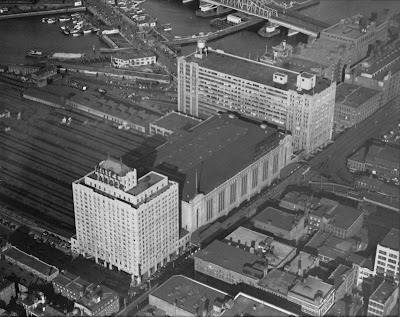
I remember as a kid in the 1960s seeing the raised platform with the old abandoned single trackbed (for the stub end of the Atlantic Av el) alongside it between the platform and the North Station building. Everyone knew, and it was pretty obvious, that it used to be for the abandoned Atlantic Ave el line.
 
Amazing. Thank you guys, and especially @The EGE and @Charlie_mta for digging out the photos. I have some track diagrams (I believe from Tremont Street Subway: A Century of Public Service) that seem to suggest that in 1908 there was a shuttle platform in between the Main Line tracks -- something like this (with the platform in orange, on the curve -- there would've been a pair of crossovers just outside of the frame of this photo, I think):

1669333087477.png


So perhaps it was rebuilt once the Washington Street Subway was opened? Certainly the photos make very clear that the platform in question was for the shuttle.

Huh, this reminds me, I have a blog post about the Atlantic Ave El that I think is basically ready to go, I really should post that...
 
Amazing. Thank you guys, and especially @The EGE and @Charlie_mta for digging out the photos. I have some track diagrams (I believe from Tremont Street Subway: A Century of Public Service) that seem to suggest that in 1908 there was a shuttle platform in between the Main Line tracks -- something like this (with the platform in orange, on the curve -- there would've been a pair of crossovers just outside of the frame of this photo, I think):

View attachment 31044

So perhaps it was rebuilt once the Washington Street Subway was opened? Certainly the photos make very clear that the platform in question was for the shuttle.

Huh, this reminds me, I have a blog post about the Atlantic Ave El that I think is basically ready to go, I really should post that...

By the way, FWIW, the date of the above photo must have been within or very close to 1929, because the Garden (which opened in November 1928) is complete, yet the Hotel Manger (which opened September 1930 and is shown at left below) was immediately adjacent to the garden, yet it is not there in the above phot, though there appears to be the very beginnings of its steel framework in the lower left of the above photo

05_02_010656_full.jpg


Above is linked from within: http://architalk-tlarson.blogspot.com/2013/03/revisiting-boston-garden-or-memories.html
...which happens to include a few other interesting vintage photos of the Garden/surroundings
 
Here's a view looking west along the shuttle platform, sometime between 1912 and 1928.

View attachment 31037
I like trying to read the ad posters in these pictures, on the right there is one for a Charlie Chaplin show at the Boston Theatre. I'm interested in the one at the end of the stub track, can anybody read it?
 
Today's blog post attempts to chronicle and illustrate the storied history of the Atlantic Avenue El's service patterns during a lively period from 1919 to 1924. As far as I can tell, BERy went through an extended period of constant experimentation, trying out what seems to be every possible service pattern along the Atlantic Ave El before (perhaps unhappily?) settling on a pattern that it maintained for several years in the 20s.

This post builds on my previous examination of "Aldgate Junctions"; I believe that the cause of BERy's struggles -- and ultimately the demise of the Atlantic Ave El itself -- can be traced to the decision not to rebuild Tower D (north of Dover station) as a three-way Aldgate Junction. BERy maintained the Aldgate Junction to the north at Tower C, but this asymmetry meant that they were stuck with the double whammy of reverse-branching to the south and the need for some degree of duplicative doubleback service -- an arrangement I argue was physically impossible to run efficiently.

This post was inspired by and draws heavily on the Wikipedia article on the Atlantic Avenue El's decline, which was carefully researched and curated by another member here at ArchBoston, who did the legwork of tracking down the original newspaper accounts detailing the endless service changes. I am in their debt; they did the hard work, I just tried to tell a story, draw some maps, and present some analysis.

Speaking of maps, here's a gif of the maps I drew for this post, inspired broadly by the spider map design of Cambridge Seven Associates:

BERY 1919-1924.gif
 
The MassDEP flickr stream is a treasure trove of old scanned slides. Here's a few, probably from the 1970s, to guess the locations of:
1669598711152.png


1669598770218.png


1669598947814.png


1669599014891.png
 

Attachments

  • 1669598708562.png
    1669598708562.png
    12.7 MB · Views: 57
I like trying to read the ad posters in these pictures, on the right there is one for a Charlie Chaplin show at the Boston Theatre. I'm interested in the one at the end of the stub track, can anybody read it?

THE NAVY'S STRENGTH IS ITS MEN. ENLIST AT ???? (partially blocked) I assume one could enlist at the next stop (Battery St. Station)

The Boston Theater poster for Charlie Chaplin's "A Dog's Life", is for his 1918 American comedy short silent film.
 
Not sure if this thread is supposed to be "Transit History" + "Trivia Quiz" or "Transit History Quiz" + "Transit Trivia Quiz", but I'll just ask my history question regardless...

So, what was special about the Highland Branch that led to it -- uniquely -- being converted to rapid transit? All of our usual suspects that we still, to this day, toss around in Crazy Transit Pitches were -- as far as I can tell -- seeing similar service as the Highland Branch: Saugus Branch, Watertown, Minuteman. Why were none of them converted to light rail?

One obvious reason I see is a lack of connection to the existing subways; the Highland Branch itself ended a stone's throw from the Beacon Portal, whereas the examples listed above were much more remote. (Though Saugus could have leveraged the connection at Sullivan to the Charlestown streetcars -- probably not viable for revenue through-running, but still could have provided a link for transferring equipment, etc.)

But the lack of connection doesn't explain why the Needham Branch wasn't also converted, and also doesn't explain why the light rail route along the B&A never materialized. (Did the construction of the Mass Pike render that proposal inviable?)

So, yeah: what was special about the Highland Branch? And, given its runaway success, why didn't we see other conversions later on?
 
It was a combination of availability/timing, low cost, and geography that came together to make the Riverside Line attractive. None of the other lines could be built as easily and quickly; those that did get built ended up being the major extensions of the 1970s and 1980s.
  • The Boston & Albany Railroad was in the process of drastically reducing its commuter service as the Mass Pike was built (and, in 1960, attempted to kill it entirely). As a relatively short line - and thus having relatively low fares - it wouldn't have generated a lot of revenue. The B&M abandoned almost all its stations within the MTA district for that reason in 1958. There was also minimal freight remaining on the line, so there was little incentive for the B&A to retain it. What freight remained could largely be served from spurs at Brookline Junction, Needham Heights, and Riverside. Several of the other lines - including the Newton Highlands–Needham segment - had a fair bit of freight remaining.

  • The entire conversion was done at extremely low cost - $9 million, or about the equivalent of $70 million today. The bridges were kept, the tracks were kept (though likely ground to a new profile), and only three of the stations were new (Fenway) or relocated (Woodland and Riverside). There was a sand pit at Riverside perfectly located for the parking lot and yard. Only 1,100 feet of tunnel was needed to connect to the Beacon Street line. The line was already grade separated, so no new separations needed to be constructed. The Central Subway had spare capacity, and no new rolling stock was needed because the streetcars were obtained by substituting cheaper trolleybuses on the Harvard lines.

    All of the other proposed lines from the 1945-47 Coolidge Commission report (the one that produced this famous map), would have required grade separations and/or more substantial connecting structures. Heavy rail extensions would require new rolling stock and larger stations. On any lines that retained a track for freight, tri-tracking the line would require major construction. Additionally, the cheapness of the Riverside Line did prove to have its downsides. The PCC cars weren't built for the higher speeds of the line, causing poor ride quality and probably maintenance issues, and the reused track had to be replaced within 15 years.

  • In the years after the Coolidge Commission, planning shifted very quickly to the suburbs and park-and-rides. Riverside being near Route 128 and the Pike made it a very attractive terminal. Several of the lines did not reach to 128, and they were the ones that went by the wayside: Lynn, Dedham, Arlington Heights via Watertown. (The 1945 map showed the Woburn line terminating at Woburn Center. The 1947 final report proposed one more stop at North Woburn, which would have been near 128.) Newton was also an area underserved by the MTA, as it hadn't been part of the district until 1947, so the line was an opportunity to gain revenue by attracting new riders.

    After 1960, rapid transit extensions were almost entirely planned around park-and-rides and replacing the unpopular elevated structures. By 1963, plans called for several extensions to 128, plus shorter extensions to park-and-rides at Milton (I-93), Revere (107), and Alewife (2). These soon became extensions to 128 at Lexington (cut back to Alewife), Reading (cut back to Oak Grove), Braintree, and Westwood (cut back to Forest Hills), which dominated the next 25 years of transit construction in the region. While most of those extensions ended up being more urban, Not until the Big Dig, with the CLF lawsuit settlement and Seaport development, did focus swing back fully to urban lines.
 
As an aside, it's worth noting four lines that show up a lot in crayons but notably weren't in the 1945 or 1963 proposals.
  • The Saugus Branch had just two daily round trips when it was discontinued in 1958. (At the time of its discontinuance, the Highland Branch had 5 inbound and 7 outbound trains, including one express in each direction, which served about 2,200 daily riders.) The majority of the density near the line is in Malden and Lynn, both of which would be well-served by existing surface lines to other rapid transit lines, and the line was grade-crossing hell. The 1963 plan considered using the Everett section for the Reading extension, but that route was soon rejected.
  • The Watertown Branch had no passenger service in 1958. The last passenger trains ran in 1938, and they hadn't been suitable for commuting for several years before that. While the 1945 proposal did reuse a section of the line, that seems to have been more for a convenient right-of-way than to serve the area. Watertown was already served by subway service (the A Branch) plus the frequent 70 and 71 trolleybus lines, and would have also been close to a Newton Corner station. The western half of the line was also grade crossing hell.
  • The Fitchburg mainline was well-served by MTA surface lines as far as Waverley. I am a bit surprised that the 1945 plan made no attempt to serve Waltham; it's the only major secondary city that wouldn't have been either served directly or by existing high-frequency surface transit.
  • The Fairmount Line had no passenger service after 1944. Its entire route was served by surface lines, and it lacked a good location to tie into any of the existing downtown tunnels. Now, with the Orange Line further away and the NSRL a possible run-through route, it becomes a rather attractive corridor for rapid-transit-like frequency.
 
(I'm not sure which thread is best for this, so I'll share it in a couple different ones, with comments specific to the topic.)

This is a project I've been working on for years, and I'm so happy that it's finally come to fruition. I present: Mapping Boston’s 1921 Subway-Streetcar Network

1692458039373.png


Lots of additional details in the blog post (including some extremely well-deserved acknowledgements).

From a transit history perspective, I really cannot emphasize enough that this was not how BERy saw their own system (as far as I can tell). We take for granted the idea that the Central Subway forms the trunk of a Green "Line". But the precursors of that idea were only put into practice in 1922; this diagram is intended to illustrate how the system looked on the eve of that transformation.

Rather than branches of a proto-Green Line, I think it's worth thinking of this as a network of local bus routes (that happened to run on rails, under wires, and underground for limited stretches). As detailed in the post, most of the routes indicated here survive in some form to the modern day. But, with the exception of the Green Line branches and the 111, all of these routes have since been curtailed to a transfer station, and no longer through-run across the core. Even the 43 and SL4/SL5 -- still running all the way to the core -- only run to one side of Downtown, and don't run through it.

And worth noting as well: one of the consequences of BERy's "it's a bunch of bus routes" philosophy is that it's not a trivial task to identify which routes through-ran at any particular point in time. As can be seen in the appendix of my post, most of our evidence comes from newspaper accounts of routes being cut back. It's a lot of digging to find those accounts though (for which I am deeply indebted to the acknowledged individuals, who did a lot of primary source research upon which I built).

But yeah. As I mentioned in the blog post, I've wanted a map like this ever since I was child. It delights me to no end that it now exists.
 
I'm doing research on Worcester Union Station to improve the Wikipedia article before the second platform is completed, so today's quiz takes us to Wormtown.
  • Union Station served trains from seven rail lines. Which one of them didn't actually enter Worcester? What other rail line entered Worcester but didn't stop at Union Station?
  • Union Station was served by intercity trains on several routes. During the early-to-mid 20th century, how many states could you reach from Worcester without changing trains?
  • When Union Station was restored in the 1990s, one part of the station had to be built anew. What, and why?
  • This is an early postcard of Union Station. What's strange about it?
    1702071532878.png
  • When Union Station was completed in 1911, its predecessor was mostly demolished. What part was kept for decades after? What part can still be found, albeit a short walk away?
  • This car rental location and the larger building across the street played a role in Worcester's transportation history. What was it?
  • Who is depicted by the statue outside Union Station? Who is depicted by the statue inside?
  • What other famous piece of transportation history is Union Station located on the site of?
  • Bonus: Penn Central had two different train stations at the same time in Worcester. Why?
 
Union Station was served by intercity trains on several routes. During the early-to-mid 20th century, how many states could you reach from Worcester without changing trains?
This one is the only one I feel I can guess on:
  1. MA
  2. RI
  3. NH
  4. ME
  5. VT
  6. CT
  7. NY
  8. PA
  9. IN
  10. OH
  11. IL
  12. NJ
  13. MD
  14. DC
  15. VA
So, 14 plus the District?
 
When Union Station was restored in the 1990s, one part of the station had to be built anew. What, and why?

The two towers. They were demolished less than 20-30 years after it was built due to vibration issues from the trains.

When Union Station was completed in 1911, its predecessor was mostly demolished. What part was kept for decades after? What part can still be found, albeit a short walk away?

The two lions outside of Christoforo Colombo park. They were previously at the end of the train shed at the original station.

https://maps.app.goo.gl/ZSowatCH4VtEQWoBA

This car rental location and the larger building across the street played a role in Worcester's transportation history. What was it?

It was for years the Peter Pan bus depot in Worcester. I don't know the full history behind Madison Place though.
 
Last edited:

Back
Top