Proposed But Never Built

eww the pru makeover looks like some crap they'd build in dubai. and the hancock redone? hideous. I prefer the current skyline, thank you very much.
 
By the time anything gets built on the old Garden parcels, the "new" Garden will be old and need replacing. I liked the area better with the old Garden and the El out front. Hopefully, there will be some big things proposed and built there in the not too distant future (5-8 years).
 
I hope that they narrow Causeway Street a bit when they develop that North Station parcel, with street level retail and the face of the new building right up against the narrowed street. The same treatment would be good to continue down in front of the adjacent Tip O'Neil Building.

That would add some urban feel back into this now suburbanized area. The old el had it's bad points, but there has been a huge loss in urban grit in this area. It looks way too open and suburban now, and Causeway Street is way too wide,
 
Hmmm. The Orange Line El was taken down on Washington St and the street didn't recover for fifteen years. The Green Line El was taken down on Causeway St and now people say it leaves the street "open and ... way too wide".

Is there a lesson here?
 
not sure, someone could definately argue people are adverse to change
 
Change here isn't the problem. The problem is the lack of density and lack of pedestrian scale. Causeway Street and the parcels to its north are just another wide open superblock on an overly wide street, the same problem afflicting Government Center and the Charles River Park apartment compex.
 
Point well taken, but are these more artery, fringe roads that can maybe handle heavy car traffic and are necessary to commuters getting in and out of the city? Obivously a study would need to be conducted, but What helps the city's economy more? And further, what's more important? asthetics or economics?
 
In the era of $4.50/gallon gas, I would say density and pedestrian friendly (i.e. narrow) streets will always trump wide open arterial boulevards. This was true 30 years ago, and it's even truer today. Any economic study justifying superblocks and multi-lane streets in the center of a city is outdated.
 
really? I hate 4.50 a gallon as well, and in fact I don't pay it.... at all. But can you prove that? So narrow streets mean underground trolleys/subways? Im just curious
 
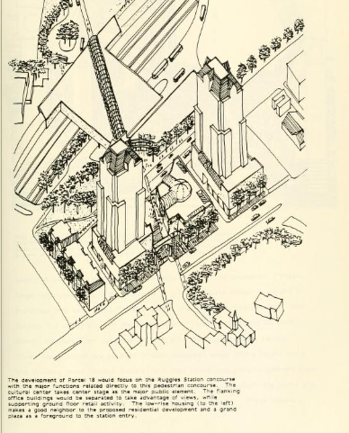
Parcel 18.

parcel_18.png


This, if I'm not wrong, is now the location of two Northeastern University dormitories. (Sort of. There are two dormitories there, but the building to the right was the Registry of Motor Vehicles building that became NeU's property.)
 
Parcel 18 is now International Village and a neighboring, non-dorm building belonging to NU. That proposal certainly looks a lot nicer than International Village, though.
 
I like the token townhouses lined along rustic Ruggles Street.
 
Back to the future; 1965/1975
http://www.flickr.com/photos/97144142@N07/9091404946/sizes/l/

I first got this map in 1966, published by the BRA in 1965, a sweeping revamping of Boston at the time. Probably a lot of the downtown and south station area plans would have materialized if not for the escalating Vietnam War draining federal funds in the mid to late 1960's.

I really like parts of it, hate others. The street pattern around Dewey Square makes sense. The surface artery south of Dewey Square through China Town would have been eliminated. There would have been an elevated moving sidewalk between South Station and Downtown Crossing (not called that back then), as well as underground tunnels for department store delivery trucks.

There was much hubris and excitement about the future back then. A deeply flawed but heroic vision presented in this plan.
 
Absolutely amazing. Such an enormous bullet was dodged. It's so tragic to see I-695 and the SWX tearing through everything and leaving ridiculous patches of proposed "open space" along them with buildings just plopped haphazardly everywhere. Boston as we know and love would have been a goner.

(Reposting map link in SWX/I-695/Mystic Valley Parkway/S. End Bypass Thread for easy reference in case someone is doing research, as I was last year)
 
Oh sweet! I have some of the neighborhood maps but not this one.

Edit: And here they are! I'll probably print these out at some point and frame the set. Charlie, I added yours. Thanks!

http://www.flickr.com/photos/vanshnookenraggen/sets/72157634370905848/

I'm glad to contribute something to the people of this site, who have given me a lot of enjoyment over the years.

I used MS Paint to restore the map, eliminate wrinkle marks, etc.

Some observations about the 1965 BRA plan for Boston:

- The railroad infrastructure was much more robust than it is today, and the planned industrial development (purple areas) are impressive. This plan was made when the US was still an industrial nation, before virtually all manufacturing disappeared to the third world.

- Apparently there would have been small to medium size patches of public housing developed throughout the Charlestown, Roxbury, South End, and South Boston areas. These may have provided more affordable housing for working people, or not.

- Obviously the highway and street development planned was over the top, decimating large sectors of the city. I think it would have transformed Boston and Cambridge into a version of Houston, with parking lots everywhere.
 

Back
Top