Proposed But Never Built

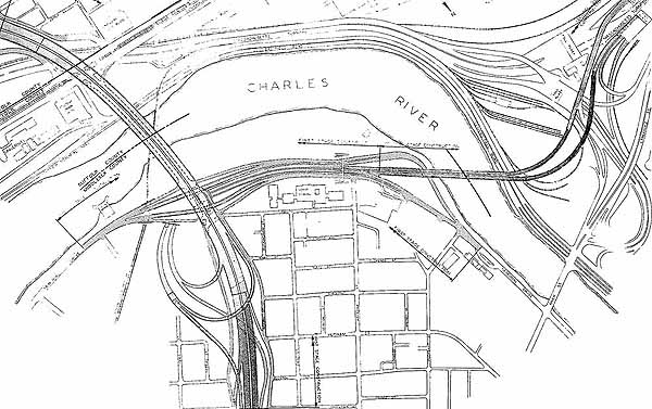
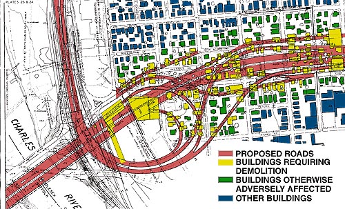
Absolutely amazing. Such an enormous bullet was dodged. It's so tragic to see I-695 and the SWX tearing through everything and leaving ridiculous patches of proposed "open space" along them with buildings just plopped haphazardly everywhere. Boston as we know and love would have been a goner.

(Reposting map link in SWX/I-695/Mystic Valley Parkway/S. End Bypass Thread for easy reference in case someone is doing research, as I was last year)

I really hope someone creates a Boston map for Cities in Motion 2. I'd love to go Robert Moses on it and throw a 10 lane expressway into the middle of the Fenway.

(Don't look at me like that, I'd put in a 10 lane expressway with a bus lane).
 
Back to the future; 1965/1975
http://www.flickr.com/photos/97144142@N07/9091404946/sizes/l/

I first got this map in 1966, published by the BRA in 1965, a sweeping revamping of Boston at the time. Probably a lot of the downtown and south station area plans would have materialized if not for the escalating Vietnam War draining federal funds in the mid to late 1960's.

I really like parts of it, hate others. The street pattern around Dewey Square makes sense. The surface artery south of Dewey Square through China Town would have been eliminated. There would have been an elevated moving sidewalk between South Station and Downtown Crossing (not called that back then), as well as underground tunnels for department store delivery trucks.

There was much hubris and excitement about the future back then. A deeply flawed but heroic vision presented in this plan.

Do you have the 1965 plans for Boston?
 
I have the book titled the "Summary 1965/1975 General Plan for the City of Boston and the Regional Core". My wife has it in her storage unit along with some other books. I plan on getting it out soon (requiring going through some packed boxes), scan some of the illustrations in it and post them on here.

I got the book in 1966 at a bookstore in Harvard Square when I was 16 and a student at Cambridge High and Latin.
 
inbelt4.jpg


inbelt1.jpg


What a devastating POS that would have been.
 
It's hard to fathom how terrible that would have been but if you look at other small cities that did build inner ring highways you can see where there were once neighborhoods that are now blocks of empty lots. Boston and Cambridge get very lucky. And better yet the money that was to be spent on these highways paid for the Orange Line and Red Line extensions.
 
I have the book titled the "Summary 1965/1975 General Plan for the City of Boston and the Regional Core". My wife has it in her storage unit along with some other books. I plan on getting it out soon (requiring going through some packed boxes), scan some of the illustrations in it and post them on here.

I got the book in 1966 at a bookstore in Harvard Square when I was 16 and a student at Cambridge High and Latin.

Yup. That's the one. I just bought it recently. The idea that I get from the plan they proposed at the time was to make the urban core of boston significantly larger and unite the city by building highways and making it easily to get around in the Boston area. There were significant expansions of the transit system proposed alongside the highways.

It's hard to fathom how terrible that would have been but if you look at other small cities that did build inner ring highways you can see where there were once neighborhoods that are now blocks of empty lots. Boston and Cambridge get very lucky. And better yet the money that was to be spent on these highways paid for the Orange Line and Red Line extensions.


That's not an entirely fair statement-- a lot of roads were built in industrial areas that have since declined or ex-rail/transport facilities that are now abandoned or empty lots (like the pike at the Allston/Brighton tolls). A big difference in Boston is that we are lucky enough that our regional economy was more than just industry. There aren't many cities that could handle the one-two-three punch of the forward progress that was mechanization, interstate highways, and containerization. We just happened to be lucky enough to have several world class educational and medical institutions that kept the engine running.
 
Last edited:
^ So much win. What is that fictitious map of North America at the start?
 
Saw this on MassDOT's Facebook page:

734053_385215454895907_10176268_n.jpg


An 8 lane freeway built over Memorial Drive in Cambridge.
 
It's not the worst idea... Memorial is already kind of a highway. That said I'll take the current version over that any day.
 
That was proposed in the mid 1960's by Mayor Velucci of Cambridge as an alternative route for the Inner Belt expressway. The logic was to sacrifice the riverfront parkway instead of 500 homes.
 
Last edited:
Um, how was that rendering done?

It looks very photo-realistic. Is it just a drawing on a photo or a photo collage?
 
Agreed, Statler. That's a great looking render, horrifying content notwithstanding.
 
I know we bang on about projects being downsized, cheapened (V-E'd to death), delayed or cancelled, but we are lucky that we avoided some of these monstrosities.
 
Um, how was that rendering done?

It looks very photo-realistic. Is it just a drawing on a photo or a photo collage?

While that rendering is exceptionally stunning, I find that alot of renderings of that time and style were highly realistic. Sometimes what we have today seems like a step backwards.
 

Back
Top