Crazy Transit Pitches

Of course, we could take a detour and have an urban ring LRV route that circumvents Chelsea Creek altogether:

View attachment 46399
I agree with @Riverside that this is likely a suboptimal solution. More importantly, though, I think we need to go back to the question of what's the problem that we're trying to address regarding a "grade-separated" Chelsea Creek crossing.

Tunnel proposals:
  • Is a tunnel so expensive that it's automatically out of question?
  • How does the cost depend on the construction method? For example, is an immersed tube tunnel feasible here (assuming it's less expensive than a bored tunnel)?
Bridge proposals:
  • Where do the problems with a bridge come from? Is it:
    • Engineering (a bridge that's tall enough may not even be feasible to fit in here in the first place)?
    • Cost (it may still be too expensive to be worth the benefits)?
    • Politics (the bridge and its inclines may be too disruptive to nearby neighborhoods)?
    • Practicality (an Eastern Ave station that's 175' tall may undermine its usefulness)?
    • Or other factors (e.g. Logan may not approve a permanent transit bridge with 175' clearance, despite them seemingly having approved the existing bridge that's 225' tall with 175' clearance)?
  • What should the vertical clearance be (60', 139' or 175')?
    • How to balance the height (cost savings, neighborhood impacts) with the number of bridge openings (unreliability)?
  • What are we designing the bridge for? This determines the grades needed, which in turns impacts cost and nearby impacts (perhaps even feasibility).
    • LRT only? That means 6-7% grade, but the steepness will have operational impacts (like Science Park-North Station).
    • HRT (or LRT with possible future HRT conversion)? That likely means 5-5.5% grade.
    • Mixed transit/road bridge? That likely means 4% grade.
Demands and benefits:
  • What's the mode of transit that we're designing this crossing for? LRT, BRT (may include T104), or APM? Or a mix of them?
  • Which route(s) run on this crossing? Does it end at Day Square, or closer to the terminals (Central Parking or Logan Terminals), or across the harbor to Seaport etc? On the opposite end, does it end at Chelsea, or through-run to Sullivan and beyond, or take other directions out of Chelsea (e.g. to Malden)?
  • Who are the riders using the crossing, and what are they using it for? Are they Chelsea (and Everett) riders heading closer to downtown - either transferring to BL, heading to the terminals, or continuing to Seaport and downtown? Or are they regional demands with air travelers (and elsewhere on the BL) from Assembly/Sullivan and further west? How many people with such demands do we expect to take this service vs. other alternatives? (Or, perhaps, are they connecting from LRT that ends at Eastern Ave to an APM that ends in the same vicinity?)
  • A distinction that's often overlooked: Are we serving air travelers or airport employees?
    • As this blogpost says: "1000 airport employees using an airport service every day are more ridership than 100,000 air travelers using it, on average, maybe a couple of times a year."
  • The above questions all lead to this: Are there enough riders using this service, to make the cost of the crossing (in whatever form) worth the benefits?
Last but definitely not least: What's the budget that you're considering or expect to have? (This not only determines the infrastructure, but also the benefits you need to achieve. In some cases, the benefit may be limited enough that the existing bridge may be OK.)

There are various combinations of answers. Different people will have different opinions, and it may be impossible to know the ground truth for each question. But I think the questions themselves are important to keep in mind.
 
Here's where I realize I should probably just change my username to "That El Stan."


Of a piece with what I posted above about LRT capacity constraints, I've been wondering for a few months now (and *think* it's possible doing some very, very rough math using Google Maps' measurement tool?) if a viaduct is the answer. The core of the idea is that the GJ ROW gives you a long run-up on either side of the Mass. Ave., Main and Broadway intersections, and the MIT Visitor lot at Vassar and Mass. Ave. gives you the space you need to translate back to the GJ.

View attachment 34410

IDK if you'd want to/have to eliminate the Mass. Ave. stop due to the security theater related to the nuclear reactor (blue circle), and you'd definitely have to fight MIT over the parking and turn lanes on Vassar, whose footprint would be needed to place supporting columns. But it does seem to sidestep the underpinning problem.
Quoting this post from February 2023 for reasons you'll see later.

I recently dug up this study for a Grand Junction multi-use path by Cambridge in October 2014. This might be old news for the forum (idk), but here are some key points:

They propose a rail-with-trail along Grand Junction with the eventual goal of connecting it to Allston. (Yes, that means going under the MIT buildings.)

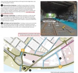
The parking lot near Mass Ave that @Aprehensive_Words proposed crossing in the comment above is out of question, as it's been reserved by MIT for future development over the tracks (shown below). Although there are currently no concrete plans, the study remarks that it's a "prime development location".
1704441568882.png

(Remark: Building 44 has already been redeveloped and covers the track.)

The rail-with-trail will most likely still ensure Grand Junction to be double-tracked east of Mass Ave. The trail is planned to be north of the existing track (as shown below), while an additional track is being planned south. However, the second track will significantly affect service routes to the back of many MIT buildings.

Regardless, Cambridge is aware of MassDOT's plans (at that time) to run DMUs along Grand Junction with 15-min frequencies, and also remarked the potential for stations at Mass Ave and Main St, explicitly quoting Urban Ring studies as the source. That would appear to indicate they're aware of both the need for a second track and the need for station sites, so let's hope that it will be integrated into planning and construction more explicitly later.

Quoting from the study:
1704442128513.png

1704442208774.png


The good news is that this project has considered traffic signals at Main St and Mass Ave with several alternatives, coordinated with nearby signals (Vassar St for the former, Vassar St and Albany St for the latter). While they will initially be used for the path, it's natural to expect they can eventually accommodate signals for LRT, and possibly even transit signal priority (though doing that with three closely spaced intersections on Mass Ave seems hard).

1704442585844.png


The study area stopped just west of Pacific St (where the MIT-owned land begins), but did briefly consider further west along BU Bridge, with several alternatives around the rotary. It noted that the rail ROW under Memorial Dr would only be sufficient for a single track and a path, but double tracking will block the path. I'm not particularly concerned about this, though, because the section immediately to the north (where Grand Junction becomes double tracked) is stated to have "insufficient space", thus the need for these different alternatives.

(The figure also confirmed the minimum width for a single CR track is 17'. However, I recall many double-tracked sections don't have as much as 34'?)

1704443053509.png
 

Attachments

  • 1704442973193.png
    1704442973193.png
    2.5 MB · Views: 17
It's apparently my week for "Crazy Transit Pitches, Unusual Modes Edition."

The Miami Metromover is one of the few, if not the only, successful APMs deployed within a city core. Miami's heavy rail system, Metrorail, has two stations in downtown, but there are somewhat on the periphery. Metromover connects to Metrorail's Government Center station, and circulates through a few bidirectional loops through downtown, essentially solving the last mile problem, and extending the reach of public transit comfortably throughout all of downtown. Stations are located about 700-1000 feet apart in downtown, with branch lines that extend north and south over divisive highways and a river, with somewhat longer distances between stops.

A rapid transit system that serves the periphery of the employment hub, with distributed destinations that are a little far to walk to from the station? Sound familiar?

The Longwood Automated People Mover, or LAPM:

1704470719625.png


(Apologies for the janky labels, my bad for not using a lossless strategy there.)

Line 1: Longwood <> Boston University Medical Center, via Longwood Ave, Ruggles St, Melnea Cass Blvd, and Albany St (2.5 miles)
Line 2: Kenmore <> Nubian via Brookline Ave, Francis St, and Roxbury Crossing (2.5 miles)

Densely spaced stations in the Longwood core provide near-front-door service for most of the hospitals. Slightly longer stop spacing elsewhere keeps travel times reasonable while still providing service to the neighborhoods that will be impacted by the construction of an elevated APM.

Miami's Metromover (which is a similar overall system length) runs about 25 feet wide between stations and about 50 feet wide at stations. It also has single track segments (including at least one that basically runs right alongside a building), which are able to fit in an envelope less than 15 away from the edge of the building (at least, according to my measurements on Google Maps). This would definitely be a tight squeeze in Longwood.

So, alternatively, the segments over Longwood Ave and Francis St could be made single-track:

1704472278222.png


(Some stop locations need to be adjusted to be closer to cross-streets if we use one-way services.)

The system can also be simplified, focusing on a Longwood <> Ruggles route (with or without the BU Med Ctr extension depicted below)...:

1704472406592.png


...or a Longwood <> Nubian route:

1704472487673.png


(Or even a Kenmore <> Nubian route but I didn't draw that one out.)

Done properly, an elevated APM could also provide improvements to the street below by providing protection from foul weather and relief from summer heat.

~~~

Now, these look cool on a map, of course, and I do think illustrates some ways that Longwood is friendlier to closer stop spacing. Plus, like, those transfers in the two-line system look pretty darn good: radial services on Washington, the SE Corridor, Huntington, and at Kenmore all get a direct transfer to services that get you a short walk away from all the hospitals, and a circumferential service on the Fenway Branch (i.e. from Harvard and/or Kendall) gets an easy transfer to solve its last mile problem.

But... as usually happens when I crayon something like this for Longwood, I come back to: well, if we're gonna build an elevated, why not run conventional light rail on it?

Well, one reason is that -- probably -- you'd want larger stations for light rail (though I suppose you could design the system for single cars exclusively). Light rail may also be a bit louder; I've noticed that APMs often use slightly more boutique technology (e.g. rubber tires), which could make an el more palatable. It's also possible that APMs could handle sharper curves than LRT, though from what I see Miami's system limits itself to 70' curves, which our light rail will continue to comfortably accommodate (I think).

But even if light rail is out... why not run the planned 30 buses per hour on the elevated instead?

Buses can handle tight turn radii (and do so quietly). Buses can run on quiet engines. You might need to use some wrong-way running if you need to resort to center platforms, but that's not super difficult. The biggest challenge would be building loops to allow buses to turn, but that's not insurmountable either.

And (a) grade-separated corridor(s) through Longwood would provide a huge reliability boost for the Dorchester bus network (along with crosstown routes like the T66 and T12) -- an infrastructure improvement whose effects would be felt not just in the local neighborhood, but across the entire system.

So... an APM would be cool, but an elevated busway -- with prepayment, level boardings, sheltered platforms, and all the amenities of modern BRT -- that would be even cooler.
 
Last edited:
Yeah, maybe, depending what you mean for the Urban Ring. The BRT proposals and some types of train proposals would just use existing road/train bridges, and that could be fine. For most UR-rail proposals, I think, there would need to be a new, dedicated crossing of the Mystic, and you're right, immersed tube tunnel might be the way to do that.

But also, a new Mystic crossing could be a simple bridge. The specific problem with the Chelsea Creek bridge is is has to accommodate large ships underneath, but a new Mystic crossing near Sullivan wouldn't have that requirement. So a new Mystic bridge wouldn't have to be a drawbridge or 150' high or whatever. Generally a bridge is cheaper than a tunnel, but that also depends on how easy it is to connect to whatever approaches from either side of the river. For that, I have no idea in this case.
@ritchiew @JeffDowntown as promised, here is F-Line's sketch of how to cross the Mystic.
 
I have a somewhat different crazy pitch for the Chelsea area, which I've been referring to in my head as the Brown X. Blue and Orange do not blend well. The OL and the BL are mostly* dimensionally compatible, once bowdoin station is replaced. The differences are overall set length and 3 inches of floor/ platform height. Some platform lengthening and curve fixes, platform replacements at BL stations or fancy auto air ballast trainsets at blue line dimensions. So why not interline?

I'm envisioning this in a world where BLX to Lynn exists, Red/Blue, etc. it only gets better as the Orange and Blue terminii extend further out. It'd allow someone living in Malden to have a one seat ride to the airport, or someone living in Lynn to have a one seat to back bay. Depending on how you work the routes endpoints, there's lots of journeys available, and if you keep the service feeds symmetrical, you shouldn't affect total trains at the major transfer points like Forest Hills or Wonderland. You also probably wouldn't need that many total tph; if a train is going to the wrong endpoint for your journey, one same platform transfer should be able to get you to where you're going. Capacity decreases would only occur in between the legs.

Plus, it's already mostly grade separated. There's a single digit number of grade crossings that'd need curing. (Necessary bridge mods not withstanding) On the Blue side, From the Airport, fork and eat the grade separated Couglin Bypass until you get to the creek, which you tunnel under, popping out past Cottage Street. The CR line through Chelsea would need grade separation between 2nd st and Arlington, but that's less than a mile of relatively simple C&C or just trenching it. The other Leg north can just share RoW with the Eastern route (Eastern Ave would either need a up or under situation) until it rejoins the Blue at Wonderland.
On the Orange side, you'd need a flyover crossing of the Mystic, branching out either side of Assembly station. Alternatively, tunnel under/swallow/follow the Northern Strand and rejoin the OL north of Malden Center.

Screenshot_20240106_130224_Maps.jpg

Screenshot_20240106_130802_Maps.jpg
 
Last edited:
^ Can I just extend a word of appreciation for the originality of this idea? While that level of interlining seems infeasible to me, at the very least it represents a novel take in a way that I think is very cool. Nice work!
 
We need a shitposting thread. (Of the fun variety, not the awful variety.) But until then: I was walking along the Greenway the other day, which, as some on Twitter have noted, still remains dominated by cars and a barrier to pedestrians (even if better than the Central Artery was). I noted the continued empty airspace between skyscrapers on either side, and was reminded of something I’ve been thinking about lately: if highways are still going to tear through the fabric of our cities, why not make the most use of their footprint? The idea of a subway or el along I-93 to Nubian, as well as my idea for an el along 95 in Providence, are in this same vein.

So, the shitpost of an idea is: just say “eff it” and build a multitrack transit viaduct above the Greenway, connecting North and South Station and beyond. The “canyon” is something like 240 feet wide, which by my math would be wide enough for 6 mainline tracks + 3 mainline platforms + 6 rapid transit tracks (and/or BRT lanes) + 3 center platforms for pretty much the whole distance. You’d have to get smashy to actually connect tracks through/around South and North Stations, but hey, this is a shitpost.

You may now prepare your rotten vegetables and catapults.
The only rotten vegetable I have is a structural one, questioning the ability of the Central Artery tunnel's roof and walls to support the columns of an elevated railway above it.

Other than that, I've always liked the idea.
 
The only rotten vegetable I have is a structural one, questioning the ability of the Central Artery tunnel's roof and walls to support the columns of an elevated railway above it.

Other than that, I've always liked the idea.
Suspend it from adjacent buildings!

I mean, I guess the other option would be to build the tracks at ground level and build a lot of overpasses (and just say screw it regarding north-south surface auto traffic).
 
Suspend it from adjacent buildings!

I mean, I guess the other option would be to build the tracks at ground level and build a lot of overpasses (and just say screw it regarding north-south surface auto traffic).
:rolleyes: The N-S link we need is the underground thru-running rail link.

Destroying the park because yeah rail, yeah El, yeah something "transitish", seem pretty poor planning.

It reeks of Gondola to the Seaport.
 
We need a shitposting thread. (Of the fun variety, not the awful variety.) But until then: I was walking along the Greenway the other day, which, as some on Twitter have noted, still remains dominated by cars and a barrier to pedestrians (even if better than the Central Artery was). I noted the continued empty airspace between skyscrapers on either side, and was reminded of something I’ve been thinking about lately: if highways are still going to tear through the fabric of our cities, why not make the most use of their footprint? The idea of a subway or el along I-93 to Nubian, as well as my idea for an el along 95 in Providence, are in this same vein.

So, the shitpost of an idea is: just say “eff it” and build a multitrack transit viaduct above the Greenway, connecting North and South Station and beyond. The “canyon” is something like 240 feet wide, which by my math would be wide enough for 6 mainline tracks + 3 mainline platforms + 6 rapid transit tracks (and/or BRT lanes) + 3 center platforms for pretty much the whole distance. You’d have to get smashy to actually connect tracks through/around South and North Stations, but hey, this is a shitpost.

You may now prepare your rotten vegetables and catapults.
You call that shitposting??

Don't build an elevated rail. Just repurpose the Central Artery Tunnel for trains!

The entrances to the tunnel are too steep, but the rest is all flat enough. For a NSRL, build portals on the south side, like currently planned, but put the underground South Station right under South Station, then the tracks break through into the current I-93 northbound. You could easily have three tracks in the northbound tunnel alone. Maybe squeeze in quad tracks, or just expand to quad tracks with the space left over when you remove the on/off ramps. Use the southbound highway tunnel for a new rapid transit line right through downtown. Rails and platforms all fit in the southbound tunnel as-is. Extend it south to wherever you want. Nubian? Mattapan? North to Chelsea? Everett? Revere? Use the steep northbound tunnel segment under Atlantic Ave to extend the Silver Line past South Station. And then all of this back to your original point, if you got rid of all the highway on/off ramps, you could just shrink the current surface streets, and make the greenway nicer.
 
Last edited:
:rolleyes: The N-S link we need is the underground thru-running rail link.

Destroying the park because yeah rail, yeah El, yeah something "transitish", seem pretty poor planning.

It reeks of Gondola to the Seaport.
To be clear: this is not a meaningfully serious proposal at all. It is meant mostly as a joke, with some slightly more serious commentary about the continued harm of highways through city centers.
 
You call that shitposting??

Don't build an elevated rail. Just repurpose the Central Artery Tunnel for trains!

The entrances to the tunnel are too steep, but the rest is all flat enough. For a NSRL, build portals on the south side, like currently planned, but put the underground South Station right under South Station, then the tracks break through into the current I-93 northbound. You could easily have three tracks in the northbound tunnel alone. Maybe squeeze in quad tracks, or just expand to quad tracks with the space left over when you remove the on/off ramps. Use the southbound highway tunnel for a new rapid transit line right through downtown. Rails and platforms all fit in the southbound tunnel as-is. Extend it south to wherever you want. Nubian? Mattapan? North to Chelsea? Everett? Revere? Use the steep northbound tunnel segment under Atlantic Ave to extend the Silver Line past South Station. And then all of this back to your original point, if you got rid of all the highway on/off ramps, you could just shrink the current surface streets, and make the greenway nicer.
And I thought my current thought process of repurposing part of the I-93 to I-90 ramp for Green Line Reconfiguration was too aggressive...
 
And I thought my current thought process of repurposing part of the I-93 to I-90 ramp for Green Line Reconfiguration was too aggressive...
😳

Too much...?

Yeah, too much. Ok, I'll dial that back.
 
😳

Too much...?

Yeah, too much. Ok, I'll dial that back.
Key facts as well -- the CAT O'Neill Tunnel does not have the height clearance for electrified rail. Minimum clearance is about 16 ft (5 M). More typical is 17 ft (5.5 M).

I think Green Line LRV or Subway would fit in there, but not Regional Rail.
 
Key facts as well -- the CAT O'Neill Tunnel does not have the height clearance for electrified rail. Minimum clearance is about 16 ft (5 M). More typical is 17 ft (5.5 M).

I think Green Line LRV or Subway would fit in there, but not Regional Rail.
I don't know how deep we want to go on this, because there are a pile of problems with what I suggested. But I don't think height clearance is one of them. The max allowed height for trucks is 13'6". That's so there is about a foot clearance under the 2-3 foot hanging road signs. That basically gets you your 17" ceiling, just eyeballing it. If that isn't quite enough, you can remove (or raise) what is now the tunnel ceiling and there is a huge amount of space above to roadway currently used for venting car exhaust. You can see just how much if you look at images of the 2006 ceiling collapse. Here are workers standing upright on the tunnel ceiling, so if you removed the panels, the tunnels are easily 20' high.

1705501687628.png
 
Last edited:

Came across this graphic in the Lower Mystic Regional Working Group "Spring 19" report. (Can it be considered a crazy transit pitch if it was put out by MAPC?)

Screenshot 2024-01-17 at 23.28.12.png
 
Included text:

ORANGE LINE SPUR ORIGINATING AT SULLIVAN SQUARE The Working Group analyzed several versions of an Orange Line spur extending from the existing Sullivan Square station. All three iterations (an extension to Route 1, an extension just to Glendale Square, an extension just to Route 16) that were tested showed robust ridership and reductions in auto mode share from 4 to 5 percent. However, the large cost of the spur alternatives, ranging from $1.25 billion to $5 billion in capital cost with annual operating costs between $35 million and $50 million, made the Working Group believe that this level of investment was much longer term in nature and needed further conceptual study. Additionally, a spur line off the Orange Line would reduce the overall frequency of service for stations north of Sullivan Square, as a percentage of trains are diverted to service the new spur line. The overall cost, feasibility, and impact on the entire Orange Line need additional study to advance this concept. In the meantime, the City of Everett requests that actions are not taken to preclude an Orange Line spur in the future. Specifically, the city requests that the MBTA reserve space at Sullivan Square station to accommodate a conjoining spur line as improvements are made to the station, that space for an expanded train bridge over the Mystic River be maintained, and that the commuter rail corridor west of the casino maintain space for additional rail tracks in the future.
 
Included text:
On the Alternative 8 page (page 90, where the above figure came from):
Potential Alternative 8: Orange Line Spur to Everett

Alternative 8 would examine the benefits of creating an Orange Line spur through Everett. This major infrastructure project would parallel the existing Newburyport/Rockport Commuter Rail ROW from Sullivan Station northward to Route 16 before entering a tunnel with a terminus near Route 60 at Copeland Circle. Possible stations could be located at Route 60 at Copeland Circle, Broadway at Mason Street, Glendale Square at Ferry Street, Everett Square at Chelsea Street, and Gateway Center at the Wynn Everett Casino. Figure 9 provides a graphic showing the alignment of the proposed Orange Line Spur.

This alternative would also examine the possibility of decreasing Orange Line headways to accommodate the necessary trains to serve the new spur and maintain existing service on the main branch. The estimated cost for the Orange Line Spur is $3,200,000,000.
The map above does a terrible job at visualizing this route: it actually largely follows Broadway, and I mapped out the station locations below (except the Sweetser Circle dot which indicates the start of the tunnel).
1705554601297.png

Overall, it's at least 3 miles of tunneling and they estimated about $1.07 billion per mile. (I think their estimate was probably more like $1 billion per mile and their actual route was 3.2 miles.)

I think the explicit mention of reducing Orange Line frequencies (Wellington and north) makes this a big question mark, especially when the Malden branch will most likely have higher ridership than the Everett branch. However, they did mention an alternative of operating this as a shuttle that ends at Sullivan.

I discussed branching the Orange Line with @TheRatmeister a couple weeks ago. At that time, my #1 issue with any thought of branching the Orange Line is that frequency reduction for Wellington and north will erase the improvements of Orange Line Transformation efforts for those riders.

OLT aims for 4.5-minute headways on the Orange Line and 3-minute headways on the Red Line trunk. It's unclear whether the Orange Line signal upgrades made any provisions for improving it further to 3 minutes. If the signal system limits OL to 4.5-min headways, then branching it is obviously a no-brainer because Malden simply can't live with 9-min headways.

The only source that hints at running 3-min headways on the Orange Line that I can find is, ironically, from the very same Lower Mystic Regional Working Group report that's being mentioned here. They explicitly mentioned further improvements - including signal - will be needed to bring the headways from 4.5 min to 3 min: (Page 30)
1705559376365.png

On one hand, this seems like they have looked into the details and concluded that it's doable. On the other hand, it does requiring more work (albeit much smaller than a new tunnel itself), and I'm not sure how reliable their claims are.

Note that improving OL to 3-min headways wasn't suggested solely for the OL spur alternative (Alt 8). Alternative 7, "ride, walk, bike", also mentioned improving OL headways to 3 minutes (including Wellington and north), and cited the following benefits:
The Orange Line headway improvements had one of the greatest positive impacts among all the elements modeled as part of the study. According to the model, daily boardings increased by 12,100 and new transit trips increased by 8,000. It also led to a 2% reduction in automobile usage in the Impact Analysis area with reduced traffic delay in Sullivan Square and other locations.

So while I'm more confident about the feasibility of 3-min headways on OL trunk than I was before, I think it's probably too immature to treat it as a guarantee. It's also another question whether 6-min headways are sufficient in serving Malden (and possibly Reading in the future), considering that in most scenarios, it will have higher ridership than the Everett branch, and it already has higher ridership than southside OL.

Edit: Chapter 5 of this 2017 MPO report, which looks at transit capacity, says the following:
The northern section of the Orange Line brings commuters from the north including Charlestown, Everett, Somerville, Medford, Malden, and Melrose. Many of these commuters connect with buses, notably at Wellington, Sullivan Square, and Haymarket.

As seen in Figure 11, in the Base Year the Orange Line is overcrowded during the last half hour of the AM peak period between Sullivan Square and Downtown Crossing, and reaches an unacceptable level of crowding between Haymarket and State. Base-Year crowding is much less severe during the PM peak period, as seen in Figure 12.

The widespread regional growth projected for the No-Build scenario will add substantial ridership to the Orange Line, significantly increasing the Base-Year crowding patterns. Crowding will be unacceptable between North Station and Haymarket for an entire hour, and between 8:30 and 8:45 AM between Assembly and Chinatown.

Many of the 72 large-impact projects summarized in Table 5 and shown in Figure 4 will be served directly by the Orange Line. These include Assembly Row, Assembly Square, North Point, West End, Old Boston Garden, Downtown Crossing, and Northeastern University. The combined impacts of these projected developments would impact the Orange Line severely if it is still operating with today’s capacity, as depicted Figure 11. Indeed, if peak-period Orange Line capacity is not expanded meaningfully, then more than half of the congested situations in the AM peak period will be congested at the unacceptable level. The reciprocal congestion during the PM peak period mirrors the AM peak congestion but at a slightly lower level of severity, as seen in Figure 12.

The MBTA is planning to procure new Orange Line vehicles jointly with the new Red Line vehicles, which will expand its vehicle fleet by about 25 percent, and vehicle capacity by 10 percent. With better equipment utilization resulting from a much lower average vehicle age, the Orange Line might be able to move 40 percent more passengers during peak periods. This increased capacity will reduce the duration and severity of crowding greatly, but even this amount of added capacity would not eliminate unacceptable levels of crowding completely.

The Orange Line vehicle fleet could be expanded further and operated safely beyond what is planned currently. However, with a more ambitious expansion program, equipment storage and maintenance capacity also would need to be addressed.
The report also includes figures which show that OL's crowding levels, especially for northside OL, are somehow even worse than RL. Keep in mind this is pre-Covid, but still. However, it does imply that much of the increased demand is due to development along the line, which are almost entirely south of Assembly.

(The document is very detailed and worth a read otherwise, which I have yet to do.)
 
Last edited:

Back
Top