Teban54
Senior Member
- Joined
- Nov 13, 2021
- Messages
- 1,126
- Reaction score
- 2,799
Quoting this post from February 2023 for reasons you'll see later.Here's where I realize I should probably just change my username to "That El Stan."
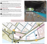
Of a piece with what I posted above about LRT capacity constraints, I've been wondering for a few months now (and *think* it's possible doing some very, very rough math using Google Maps' measurement tool?) if a viaduct is the answer. The core of the idea is that the GJ ROW gives you a long run-up on either side of the Mass. Ave., Main and Broadway intersections, and the MIT Visitor lot at Vassar and Mass. Ave. gives you the space you need to translate back to the GJ.
View attachment 34410
IDK if you'd want to/have to eliminate the Mass. Ave. stop due to the security theater related to the nuclear reactor (blue circle), and you'd definitely have to fight MIT over the parking and turn lanes on Vassar, whose footprint would be needed to place supporting columns. But it does seem to sidestep the underpinning problem.
I recently dug up this study for a Grand Junction multi-use path by Cambridge in October 2014. This might be old news for the forum (idk), but here are some key points:
They propose a rail-with-trail along Grand Junction with the eventual goal of connecting it to Allston. (Yes, that means going under the MIT buildings.)
The parking lot near Mass Ave that @Aprehensive_Words proposed crossing in the comment above is out of question, as it's been reserved by MIT for future development over the tracks (shown below). Although there are currently no concrete plans, the study remarks that it's a "prime development location".
(Remark: Building 44 has already been redeveloped and covers the track.)
The rail-with-trail will most likely still ensure Grand Junction to be double-tracked east of Mass Ave. The trail is planned to be north of the existing track (as shown below), while an additional track is being planned south. However, the second track will significantly affect service routes to the back of many MIT buildings.
Regardless, Cambridge is aware of MassDOT's plans (at that time) to run DMUs along Grand Junction with 15-min frequencies, and also remarked the potential for stations at Mass Ave and Main St, explicitly quoting Urban Ring studies as the source. That would appear to indicate they're aware of both the need for a second track and the need for station sites, so let's hope that it will be integrated into planning and construction more explicitly later.
Quoting from the study:
The good news is that this project has considered traffic signals at Main St and Mass Ave with several alternatives, coordinated with nearby signals (Vassar St for the former, Vassar St and Albany St for the latter). While they will initially be used for the path, it's natural to expect they can eventually accommodate signals for LRT, and possibly even transit signal priority (though doing that with three closely spaced intersections on Mass Ave seems hard).
The study area stopped just west of Pacific St (where the MIT-owned land begins), but did briefly consider further west along BU Bridge, with several alternatives around the rotary. It noted that the rail ROW under Memorial Dr would only be sufficient for a single track and a path, but double tracking will block the path. I'm not particularly concerned about this, though, because the section immediately to the north (where Grand Junction becomes double tracked) is stated to have "insufficient space", thus the need for these different alternatives.
(The figure also confirmed the minimum width for a single CR track is 17'. However, I recall many double-tracked sections don't have as much as 34'?)


