I appreciate someone trying to solve that BU bridge riddle, but I'm not sure if all of those routings work. We've had a couple debates on this forum about how to do it in the past.
RE: A branch bike lanes, obviously we care about trains more than bikes. Not sure why this is a question.
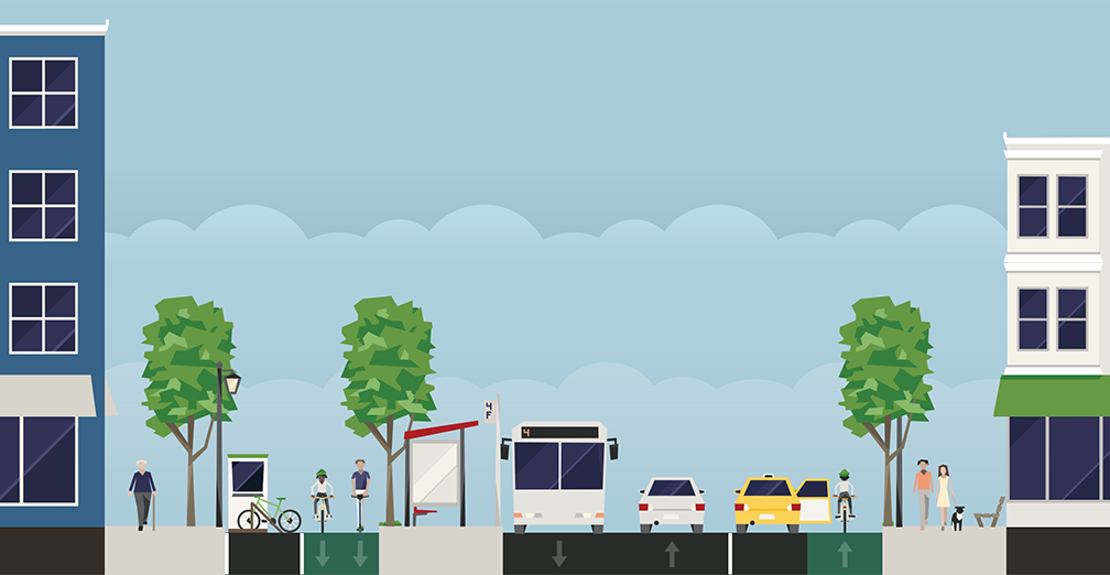
Correct me if I'm wrong, but I'm not seeing anywhere on the old A-line route with less than 80' of RoW until it becomes Washington Street where it drops to 70'. There's no concerns on this segment about having green line, grade separated bike lanes, sidewalks, and travel lanes in each direction.
Once you reach Washington Street, cut one of the travel lanes. Make it east bound only (to preserve access to St. Elizabeth). Divert westbound drivers onto Sparhawk/Arlington/Faneuil. That frees up space to maintain green line as well as bike lanes in both directions and sidewalks.
I'd be VERY interested in an updated version of this map, and hopefully we get something like it with the upcoming GoBoston 2030 update. Bluebikes has so much more reach than Hubway did a decade ago, and with Turo and GetAround coming on the scene I don't think there is an inch of Boston that isn't within a 10 minute walk of carshare.
I'd be VERY interested in an updated version of this map, and hopefully we get something like it with the upcoming GoBoston 2030 update. Bluebikes has so much more reach than Hubway did a decade ago, and with Turo and GetAround coming on the scene I don't think there is an inch of Boston that isn't within a 10 minute walk of carshare.
It's kind of limiting that there isn't an updated version of the map.
The transit coverage would be smaller for the KBRs since some of the KBRs currently fail to meet KBR standards. (requirements for KBR is 10 minute headways rush hour and 20 minutes off peak). The 57 is only running 11 - 13 minutes at rush hour and the 39 runs every 23 minutes on Saturdays, failing the KBR standards.
I'd also be interested to see the map covering the entire BERy service area + Lynn/Quincy/Waltham. I'd imagine Medford/Malden/Everett would appear as one giant desert except for Malden Center.
I've been lurking for a while and got around to making my own fantasy T map. I call it Giga MBTA and it’s inspired by a lot of the helpful info on this forum along with a few ideas that I like. I tried to not make it entirely crazy by looping in projects that are being proposed in one form or another. I’m planning on working back from this toward a more reasonable pitch that doesn’t require as many MEGA-projects and is a little nicer to those who like street parking.
Sorry I didn't get a chance to reply sooner, but first of all, excellent work, this looks so cool! Lots of excellent stuff all around.
Some random examples of things I liked include your studious attention to indicating walking transfers (nicely including time estimates) as well as your "light touch" for indicating bus corridors. Bus corridors in particular can be very hard because it's easy to try to do "too much" with them (such as by explicitly marking all relevant routes, see for example my monstrosity of an attempt to redesign the T's system diagram), and I like that your map is much more sparing in its detail. Enough to illustrate that there is important transit infrastructure there, but not so much that it overwhelms.
(I also am a big fan of Indigo-via-Tobin, even though there are substantial engineering challenges to overcome.)
I might offer more comments later, but to briefly respond to a couple of things:
I think a surface running line is a massive upgrade on the noise and pollution of Storrow drive which is already such a barrier between the residential and the espanade. Surely replacing a few Storrow lanes wirh a mostly straight electric rail line would be quieter, cleaner, and more aesthetically pleasing than what is there now?
I think it's worth clarifying a little bit what F-Line is describing by a "capped cut". Basically, steal a number of lanes of Storrow (as you describe), sink them down a little bit (gonna make up a number here, but let's say 6 feet), and then build a relatively thin "cover" over the top and down the side. (Using the existing barrier wall to form the other side.) That cover could then, for example, get grass/greenery put down and bring Back Bay all the closer to the river, offsetting the impact of Storrow Drive even further. So, basically the same as what you're proposing, but with a roof and walls to make the environment even more pleasant.
I may have a more detailed diagram lying around (been meaning to collate those, but alas), but I have a brief description here.
Ah, okay, here's a very rough sketch:
Basically the tunnel gets threaded very carefully from the Exeter/Huntington/Stuart intersection under Stuart Street/the plaza outside Copley Place, into a new light rail station under the plot currently occupied by the Clarendon Street Garage. From there, the subway would run in a cut-and-cover along the Mass Pike until it reaches Bay Village.
I opted for a lower-frequency connector line between Millenium Park and Newton Highlands to maintain some service to Needham. As others have proposed, it could function similarly to the Mattapan heritage trolley line today but I know the PCC cars are being replaced soon anyway.
As the person who most recently suggested something like this, I do want to clarify that I think the only way it could make sense to run heritage trolleys/a shuttle service in Needham is if you have at least one full-time rapid transit service terminating within town limits (e.g. at Needham Heights). My suggestion was actually to bring rapid transit to three out of Needham's four stations, leaving Needham Center the only one relegated to a two-seat ride. Because yes, otherwise it's too severe a degredation of service.
Haven’t seen anyone else propose connecting this GL branch to porter along with the popular Union Square to Porter GL D extension. A loop here doesn’t seem impossible to me if you take 2 lanes from Mass Ave for a LRT/bus lane. Does another ring make sense?
It occurred to me about a year ago that something like this could give you a Sullivan <> Harvard connection that stays within existing rail ROWs/corridors, which is intriguing on paper. In practice, I agree that the number of intersections you'd need to blow through at-grade makes it prohibitively slow, and building a second tunnel is an expensive investment for something that (IMO) is not a pressing need.
That being said, if you want to do some fun outer loop stuff, you could play around with a service going Sullivan <> Porter <> Watertown Branch, hooking into your Aqua Line.
Like I said, really cool map! You've got some great ideas here, and the map itself also looks great!
When I lived out that way, I usually rode on Faneuil/Arlington/Sparhawk, rather than Washington St. But when my daughter lived there, she rode on Washington, mainly because it has bike lanes. In my opinion, the route I used is still perfectly viable, especially with some infrastructure upgrades. Make that the main bike corridor, and Washington the main transit corridor. Yes, ideally you'd have both on Washington, as that is the commercial street, but space constraints may require compromise.
You can do a lot with some creative lane management. Getting to St Elizabeths is no problem, Brighton Ave/Cambridge St are already wide enough, although a lot of street parking will need to be sacrificed on Cambridge St. From there you could terminate the line by looping it around the BPD station. From there we have two options, either lean into using Sparhawk/Arlington/Fanueil as a bike corridor and Washington as a transit corridor, or get pretty crazy on Washington. For the latter, it would require first running outbound trains on Henshaw St, then single tracking to Oak Sq with double tracked stations at Foster St and Langley Rd.
You can do a lot with some creative lane management. Getting to St Elizabeths is no problem, Brighton Ave/Cambridge St are already wide enough, although a lot of street parking will need to be sacrificed on Cambridge St. From there you could terminate the line by looping it around the BPD station. From there we have two options, either lean into using Sparhawk/Arlington/Fanueil as a bike corridor and Washington as a transit corridor, or get pretty crazy on Washington. For the latter, it would require first running outbound trains on Henshaw St, then single tracking to Oak Sq with double tracked stations at Foster St and Langley Rd.
I would be very curious how @F-Line to Dudley would handle trying to bring the A branch down westwards from Brighton Center along Washington Street, if bi-directional dedicated bike lanes on Brighton, Cambridge & Washington Sts were a mandatory requirement as part of the build, regardless if the A branch is brought back or not.
Single tracking west of Brighton Center is an interesting idea, but in that case, keeping the loop at the police station is probably preferable for short turns in case of reliability issues, or for increased headways east of Brighton Center. Still, there's going to be the issue of where to shove station platforms/waiting areas in between the streetcar tracks, travel lanes, dedicated bike lanes, and sidewalks. The inbound/outbound stops definitely going to have to be offset quite a bit from each other.
Co-mingled on wider Brighton + Cambridge, then Sparhawk/Arlington/Fanueil alternate bike corridor all the way. I don't see any problem with that.
Sorry, Delvin...it's not going to thrill you, but the capacity of a loaded Type 10 trolley running every 6-12 minutes absolutely dwarfs the hourly usage of the Washington bike lanes even at peak utilization. This isn't a contest the bikes are going to win. But they don't have to lose it, either...that alt. corridor does exist.
In having these types of conversation online, it is shockingly frequent to see bicyclists defending their "turf" over bus and/or rail expansion. I had someone heap scorn on the idea of the red line to Arlington heights because of potential loss of or narrowing of the minuteman even though its utility as a rail corridor would vastly dwarf its utility as a bike commuter highway. In a way I get that losing something that feels exponentially safer than unprotected bike lanes is a difficult prospect, but there is a limit.
Idk if it's really shocking that people want to defend the thing that they use in their day-to-day life. It's the same impulse as defending street parking in your neighborhood, if with significantly fewer societal externalities. Most people don't think in utilitarian fashion when it comes to something they use. I understand all the faults of the old Quincy bus depot and the benefits of the new one but still hate that the new one is going where it is. It's really important for both advocates and professionals to have some empathy in these situations.
But in this particular case, it's important to remember that biking and light rail are serving two different functions. From the ivory tower of the state transportation building (and having lived on Fairbanks St) I agree that the latter has more net utility than the former...but I still contend that the bike lanes don't need to be the trade-off here. The westbound travel lane has, imo, the least utility. Now the politics may decree that it's either rail with no bike lanes or no rail at all, in which case yes I think the bike lanes are an unfortunate but worthy tradeoff, but as long as we're in the fantasy T maps thread I don't see any reason why they need to be.
Sure, shockingly is the wrong word but it is hypocritical to decry personal use infrastructure for thee but not for me on main thoroughfares and right of ways even if the empire of degrees is different.
I agree with F-Line in terms of the layout. There are way too many roads connecting to Washington street to remove vehicle lanes without creating a chaotic pattern of car traffic needing to cross the tracks every block especially if the kept lane is eastbound. Your setup (and really the geometry of the real world space) doesn't leave room for platforms.
As to the bounds of fantasy in this conversation? Put the train in a tunnel; problem solved. Better yet, stop putting more lines on the Boylston street subway and make new ones like a comm ave subway that connects at Kenmore, Park, Reconfigured Bodwin, North Station, and then up onto the viaduct to go somewhere else. That's not really directed at you @KCasiglio, but it is frustrating that on one hand you are asking the conversation to be unbound by constraint when we are talking about fantasies that are clearly bound by real world constraints of some notion. I am particularly annoyed at crayon drawers inability to stop hubbing additional lines onto the Green Line through the core especially when a big push here is to remove the D line from Kenmore to make ops better. From the north, sure. From the West, NO! Dream bigger.
As to the bounds of fantasy in this conversation? Put the train in a tunnel; problem solved. Better yet, stop putting more lines on the Boylston street subway and make new ones like a comm ave subway that connects at Kenmore, Park, Reconfigured Bodwin, North Station, and then up onto the viaduct to go somewhere else. That's not really directed at you @KCasiglio, but it is frustrating that on one hand you are asking the conversation to be unbound by constraint when we are talking about fantasies that are clearly bound by real world constraints of some notion. I am particularly annoyed at crayon drawers inability to stop hubbing additional lines onto the Green Line through the core especially when a big push here is to remove the D line from Kenmore to make ops better. From the north, sure. From the West, NO! Dream bigger.
If we're talking about burying the A branch in the tunnel and building a new subway through Back Bay, at that point, one may as well just send rail transit down the B & A railroad along the Pike.
Washington St. already has dozens of unknown street utilities beneath the ground, so tunneling beneath the A branch is going to be extremely problematic with cut and cover or TBM. Plus the hilly terrain, plus sharp curves to get in and out of either side of Cambridge St and around Lake St. and Oak Sq. in particular.
Tunneling beneath the B & A is a lot more straightforward. Just take a single lane of the Mass Pike, tempoarily single track the B & A between each pair of switches, and do a capped cut for each pair of track and between each pair of switches. It's highly unlikely there would be that many utilities beneath a pre-existing railroad. After that, reconfigure the entire bus system, reroute the 64 to Brighton Center from Allston Depot and eat away at the original A alignment with added frequency, for a new OSR crosstown connection to Cambridge to eliminate the route duplication along Boston Landing.
On another related note, I've also made a handful of changes to the fantasy frequent network map that was initially in the fantasy T maps thread, that accompanies this absurd "mainline rapid transit network" concept... the fact that the Nubian terminal was literally the only terminal without a rapid transit hookup).
How about a v3 of the "fantasy frequent network" map of Greater Boston?
On this third version of the map, I eliminate half of all the low frequency one seat rides to Downtown Lynn, Downtown Quincy, Roxbury, and Newton Corner, and vacated them out to an outlying rapid transit hub, so long as to quell the remaining low frequency duplicated routes that ran into the city center. Instead of an every 20-30 minute low frequency trip to downtown Roxbury/Quincy/Lynn duplicated by half of the routes; replace them with an every 15 min, high frequency trip to an outlying rapid transit terminal, then high frequency rapid transit into downtown Lynn/Quincy/Roxbury/etc. from the outlying rapid transit terminal.
For example, instead of an hourly 230 bus to Quincy Center from Holbrook, instead run the 230 at higher frequency (say, every 40 - 45 min) to Braintree Square, then transfer to rapid transit to continue to Quincy Center. Almost half of the 230's rotation of duty cycles is spent simply duplicating the Old Colony rapid transit line! Madness! No wonder why the old maps show terrible headways in the outlying Quincy/Lynn/Waltham terminals. (The removal of the historical OC stops for extra-wide stop spacing certainly doesn't help)
The largest changes is that the area of Quincy and Lynn covered by frequent service expands dramatically, with Lynn's frequent network now extending from Swampscott to Salem. The same with Waltham/Newton's frequent grid now extending out to Market Place Drive and Auburndale after curtailing the duplicated 55x routes along I-90 out from Newton Corner.
(Note: A few (or some) of the regional rail lines are placeholders, as some of them are less useful than others)
Frequent service coverage: (on top left; Red = rapid transit; Purple = frequent surface route); Population density covered by frequent service (on bottom right; Orange = served by frequent service, Gray = no frequent service)
Long time lurker, but first time posting, and absolutely loving the discussion of A branch to Brighton. I use the bike lanes through Brighton Center, down Washington, Brighton Ave and Comm Ave every morning because the 57 is so slow and inconsistent (also since my destination is near Lechmere). I definitely agree that keeping them is a huge win, but consistent high frequency transit on this corridor is a greater need, and bike lane alternatives do exist.
As another slightly less crazy idea to leverage the ROW more effectively with very little new build infrastructure need, have folks considered running a few sets of DMU or BEMU rolling stock on the section of the Worcester Line between Boston Landing, in the future West Station, Lansdowne, Back Bay, and South Station? Potentially even extended along the I-90 ROW to 10/15 minute peak hour frequencies could be achieved with what I'd guess is just a need for updated signaling, a crossover switch east of Boston Landing, and getting stock that can support the platform heights. Something like the Nippon Sharyo DMU (SMART/Union Pearson Express stock) or some of the newer Stadler BEMU that the T wants to use on the Fairmount line. There's already catenary between Back Bay and South Station for the NEC/Providence Line, so that could even be used as a charging segment?
Would love to hear what folks think. This could also help leverage Boston Landing as a rapid transit bus hub and speed up trips to downtown.
In having these types of conversation online, it is shockingly frequent to see bicyclists defending their "turf" over bus and/or rail expansion. I had someone heap scorn on the idea of the red line to Arlington heights because of potential loss of or narrowing of the minuteman even though its utility as a rail corridor would vastly dwarf its utility as a bike commuter highway. In a way I get that losing something that feels exponentially safer than unprotected bike lanes is a difficult prospect, but there is a limit.
I see this a lot, too, and as a strong proponent for and happy user of more bike infrastructure, I tend to disagree with such arguments. The example I use most often is the Columbus Ave center running bus lanes project. There was no room in the corridor to accommodate bike lanes but the transit value add was substantial. I'll take that over bike lanes every day, especially if there is an effort to eventually develop alternatives. As for the Minuteman Bikeway, that's a tougher sell in my opinion because it's not an example of improving bad transit for people with few other options. And there is now a pretty long history of that ROW being used by a lot of bike riders. Temporary narrowing or closure during construction would be completely fine, but permanently diminishing the resource is something I'm not persuaded should happen.
Long time lurker, but first time posting, and absolutely loving the discussion of A branch to Brighton. I use the bike lanes through Brighton Center, down Washington, Brighton Ave and Comm Ave every morning because the 57 is so slow and inconsistent (also since my destination is near Lechmere). I definitely agree that keeping them is a huge win, but consistent high frequency transit on this corridor is a greater need, and bike lane alternatives do exist.
As another slightly less crazy idea to leverage the ROW more effectively with very little new build infrastructure need, have folks considered running a few sets of DMU or BEMU rolling stock on the section of the Worcester Line between Boston Landing, in the future West Station, Lansdowne, Back Bay, and South Station? Potentially even extended along the I-90 ROW to 10/15 minute peak hour frequencies could be achieved with what I'd guess is just a need for updated signaling, a crossover switch east of Boston Landing, and getting stock that can support the platform heights. Something like the Nippon Sharyo DMU (SMART/Union Pearson Express stock) or some of the newer Stadler BEMU that the T wants to use on the Fairmount line. There's already catenary between Back Bay and South Station for the NEC/Providence Line, so that could even be used as a charging segment?
Would love to hear what folks think. This could also help leverage Boston Landing as a rapid transit bus hub and speed up trips to downtown.
Allston/Brighton is one of the (Relatively few, actually) places (Along with Newton also on the Worcester Line) where all-day 15 minute headways on the CR are super important for urban rapid-transit-esque service, but Boston Landing and a future West Station also aren't positioned super well for filling this role outside of a very limited area. The lack of fare integration and the fact that Boston Landing has basically no room for a bus station certainly doesn't help things either.
Long time lurker, but first time posting, and absolutely loving the discussion of A branch to Brighton. I use the bike lanes through Brighton Center, down Washington, Brighton Ave and Comm Ave every morning because the 57 is so slow and inconsistent (also since my destination is near Lechmere). I definitely agree that keeping them is a huge win, but consistent high frequency transit on this corridor is a greater need, and bike lane alternatives do exist.
As another slightly less crazy idea to leverage the ROW more effectively with very little new build infrastructure need, have folks considered running a few sets of DMU or BEMU rolling stock on the section of the Worcester Line between Boston Landing, in the future West Station, Lansdowne, Back Bay, and South Station? Potentially even extended along the I-90 ROW to 10/15 minute peak hour frequencies could be achieved with what I'd guess is just a need for updated signaling, a crossover switch east of Boston Landing, and getting stock that can support the platform heights. Something like the Nippon Sharyo DMU (SMART/Union Pearson Express stock) or some of the newer Stadler BEMU that the T wants to use on the Fairmount line. There's already catenary between Back Bay and South Station for the NEC/Providence Line, so that could even be used as a charging segment?
Would love to hear what folks think. This could also help leverage Boston Landing as a rapid transit bus hub and speed up trips to downtown.
Route 57 Transit Priority Corridor - We're designing changes to city streets to improve bus service along the Route 57 corridor in Allston and Brighton. - - The Boston Transportation Department is planning improvements to the Route 57 corridor to reduce transit delay, enhance safety, and reduce...
Route 57 Transit Priority Corridor - We're designing changes to city streets to improve bus service along the Route 57 corridor in Allston and Brighton. - - The Boston Transportation Department is planning improvements to the Route 57 corridor to reduce transit delay, enhance safety, and reduce...
The proposed project documents only show very small stretches of bus and bike/bus lanes, at least for the relevant stretch along Washington St in Brighton.
At long last, I now present the: Blue Line Extension to Salem (from Swampscott) - pretty big extension of the frequent transit network (4th iteration)
(Thicker and darker lines denote higher frequency, excluding CR (thin lines) and historical RRs; ignore the fantasy map that is Malden/Melrose, that is part of the fantasy land "Boston Metropolitan Railway" concept below)
On my third iteration of the fantasy frequency map that extended the Blue Line to Swampscott (NOT Salem), Salem stuck out as the biggest remaining transit desert on that map. The Salem area is the most unique out of all the outlying densely populated areas; being an major extension of the Lynn terminal, out of the 3 outlying major terminals outside of the inner core (Lynn/Quincy/Waltham). Compared the KBR status of the 220/222 in Quincy under BNRD, population densities in Salem are actually enough to give 3 corridors of 15 minute KBR frequencies, surprisingly! These corridors would be the 435/465 to Peabody, 451/451A to Beverly, and the 454/455 to Salem State.
Danvers gets a circuit, technically 15 minute headways between Danvers and Salem if going via either side of the circuit from Danvers Sq. Marblehead has issues with reverse branching, but technically it'd be KBR levels if it weren't for reverse branching.
Aside from the restoration of the 454 (and the 465 technically), no new routes in the North Shore or metro north are introduced or re-introduced; beyond those that existed across the MBTA since 2012 (BLX massively improves service span of the 428/436/439/451). Instead, the focus should be on providing quality high frequency service in dense urban cores; instead of crappy hourly service suburban/rural routes.
After the Blue Line Extension to Salem, the high frequency grid could extend from Salem to include portions of Beverly and Peabody, although the frequent coverage area would no longer be contiguous between Lynn and Salem, once Salem gets rail frequencies instead of bus frequencies out from Swampscott. The vast majority of large contiguous areas with over 10,000 people per square mile (3,850 people per sq kilometer) could be covered with frequent service.
Notably absent on this map is Reading, Lexington, Needham, all of the Green Line D Branch within Newton, South Braintree station of the Red Line, as well as a small area between Newton Corner and Oak Square. This does not mean they don't deserve frequent service. The D Branch in Newton and South Braintree station of the Red Line are more or less "unicorns" in a way. They simply got lucky and gained high frequency service, despite having lower densities further removed from Boston; before other more densely populated transit deserts did (including Beverly, Charlestown, Roslindale, Medford, East Malden, Everett, etc.).
This also means that after BLX-Salem, there aren't really any additional rapid transit extensions that would signficantly impact the bus system in a signficant positive way (as far as iterating my map again, goes). BLX-Salem is the "last" major one (in terms of a 22 km/14 mi distance to Downtown Boston). If a rapid transit extension after that needs to redistribute bus headways outwards, then rapid transit swallowing Peabody and Beverly is the only possible way after that (Enjoy messing around with the Salem RR tunnel). Only then, can one start introducing new suburban/rural bus routes extending outwards in the North Shore. If I made such a 5th map, I'd have rapid transit swallowing the Peabody and Beverly KBRs whole, bus terminals shifting outwards to the Peabody/Beverly railroad junctions. Then redistribute bus headways to restore KBR frequency on the 455 between Salem and Hawthrone's Crossing filling in the gap left behind with BLX-Salem, and maybe perhaps the then-truncated 435 to Peabody terminal and the outer segment of the 450 could gain KBR status (removing the 424).
Population served with fantasy frequent service: 1,459,620 (86.9%) - MBTA today: 765,262 (45.5%)
Population served with rapid transit: 936,400 (55.7%)
Population of BERy/Lynn/Waltham/Quincy/Melrose/Salem/Peabody/Beverly (>10,000 ppl/mi^2): 1,680,104
The MBTA should've included space on their spider frequency map to fit in the North Shore out to Beverly . Without BLX-Salem they really left off the entire North Shore off the spider frequency map. I had to shift the entire Lynn area and condense it/cram it into the northeast corner of the map, to maintain the same aspect ratio as the original MBTA spider map. It was the only way to slot in Salem, Peabody Square, and Beverly; onto the high frequency grid and keep the image the same size as the original MBTA spider frequency map.
Rapid transit milage: 138 miles (222 kilometers), #26 compared to Aug. 2024 worldwide metro systems (wikipedia), #10 outside of China/Russia.
BLX-Salem compared to the rest of the fantasy frequent map: (This version of the map once again includes all historical RRs compared to the BLX-Salem snippet above, I've collapsed the original post above to only show this one now)
Imagine in Riverside's "Boston Metropolitan Railway" concept, the Blue Line eventually gets converted to standard gauge and through routed with the Cambridge Subway? (i.e., instead of the Cambridge-Dorchester tunnel, the Cambridge Subway instead runs to East Boston and onwards to Revere Beach. The Shawmut Branch and Quincy Center Branch railroads instead remain on the mainline and connected via NSRL. Now extend the Cambridge-East Boston subway from Lynn to Salem and there would be this madness of a line where one side ends 5.5km (3.4mi) away from Boston, and the other 22km (14 miles out)! Kinda wild to think about! Then throw in an extension to Beverly Junction for a bit more craziness!






 . Without BLX-Salem they really left off the entire North Shore off the spider frequency map. I had to shift the entire Lynn area and condense it/cram it into the northeast corner of the map, to maintain the same aspect ratio as the original MBTA spider map. It was the only way to slot in Salem, Peabody Square, and Beverly; onto the high frequency grid and keep the image the same size as the original MBTA spider frequency map.