B Line Improvements

Wow BU isn't even going to chip in?

Yay! Aside from the insanely useless nature of half the stops located along their campus, this is all the more reason to shutter half of them.

Sidebar question: I'll soon be moving to the Aberdeen neighborhood of Brighton to be 2 minutes from the B, 5 minutes from the C and maybe 8-10 minutes from the D. Coming home I'll take whichever train comes first (which is awesome) but which train would you head towards in the morning?

D is probably your best bet given it sees more capacity than the B or C. I was in a similar situation before I moved to Rozzie (lived 7 mins from B, 12 from C and 15 from D) and would usually take the B inbound if I made it there before 7:30. Anytime after that and things start to get crazy.
 
Sidebar question: I'll soon be moving to the Aberdeen neighborhood of Brighton to be 2 minutes from the B, 5 minutes from the C and maybe 8-10 minutes from the D. Coming home I'll take whichever train comes first (which is awesome) but which train would you head towards in the morning?
When I lived in that neighborhood, I took the D most days, unless I really wasn't in the mood to walk due to weather or whatever, then I used the B (and left an extra half-hour early)...
 
When I lived in that neighborhood, I took the D most days, unless I really wasn't in the mood to walk due to weather or whatever, then I used the B (and left an extra half-hour early)...

Yeah, the weather is really the only reason to take the B that far down the line if C and D are good options. Coming home you'll probably end up feeling the same way and passing up on B, unless it's the third B in a row so you know you'll at least get a seat (and that the C and D will likely be packed when they finally appear).
 
With this (http://www.boston.com/health/2014/0...story.html?p1=Topofpage:Carousel_sub_headline) news story, it got me thinking again about stop consolidation on the B line. Here's how I'd do it:

Starting with Boston College (kept obviously):

REMOVE South St.
KEEP Chestnut Hill Ave.
CONSOLIDATE Chiswick Rd and Sutherland Rd. into one stop in between the 2
KEEP Washington St.
KEEP Warren St.
REMOVE Allston St.
KEEP Griggs St. (though I'd also keep Allston and remove Warren and Griggs)
KEEP Harvard Ave.
KEEP Packard's Corner
REMOVE Babcock St.
KEEP Pleasant St.
REMOVE St. Paul's St.
KEEP BU West
CONSOLIDATE BU Central and BU East (call it BU East)
KEEP Blanford St.

I'd love to find out how much that would speed things up with signal priority also in use
 
stop consolidation on the B line
It is very much needed. Fewer, more accessible stops with better amenities would be a huge benefit. Anyone know what the outcomes were that were measured the last time the B had stops removed? WIkipedia seems to cover it pretty well:
https://en.wikipedia.org/wiki/Green_Line_"B"_Branch

I'm guessing that on a 27 minute trip from BC to Kenmore, each stop "costs" about 30 seconds but more during rush hour. Eliminate ~6 stops and you cut travel times by 3 minutes (or more) (10% or more).

If we can't have proof-of-payment to facilitate all-doors boarding, the alternative is putting faregates on the platform ends at, say, 3 consolidated stops in what is now the 5-stop Blandford-St.Paul stretch (e.g. close Blandford and replace BU West/St.Paul with 1 stop, since the Central and East are pretty nice as is. They just need longer shelters.

Or wide center platforms with farecontrol at the ends.
 
REMOVE South St. - Meh, it covers a decent gap, and is basically the end of the line. I'd leave it.
KEEP Chestnut Hill Ave. - Yes
CONSOLIDATE Chiswick Rd and Sutherland Rd. into one stop in between the 2 - Look at the street grid, you'd be forcing everyone to walk a lot further. Also, these stops are almost exactly a quarter mile apart. I'd say keeping both is safe.
KEEP Washington St. - Yes.
KEEP Warren St.
REMOVE Allston St.
KEEP Griggs St. (though I'd also keep Allston and remove Warren and Griggs)
- I would close Griggs (useless) and keep Allston St open - It grabs a lot of traffic from Union Square and lower part of Corey Hill. I'd keep Warren open, but only during high school hours. It gets a ton of business then.
KEEP Harvard Ave. - Of course.
KEEP Packard's Corner Yes, but I'd move it to the other side of the intersection in front of shaws.
REMOVE Babcock St. Yes.
KEEP Pleasant St. Yes, but move it to the other side of the intersection, in front of the Agganis Arena.
REMOVE St. Paul's St. Yes
KEEP BU West Yes, but I'd move it a few hundred feet east, right at the traffic light.
CONSOLIDATE BU Central and BU East (call it BU East) The issue with this is you'd loose the left turn lane for St Marys St. I'd just straight up close BU Central, and leave BU East as-is.
KEEP Blanford St. - You'd need to, as the T wan't a station right at the portal for emergencies. It might not be a bad idea to have it only be open for sox game days only, or something. It kills the schedule.
 
I think there's a few things that need to be done:

-- Extend the platforms to uniform 3-car length.
-- Offset them on opposite sides of intersection when that makes sense. Don't offset them when that a) hampers 3-car platform length, b) hampers short-turn efficiency, c) hampers alt-routing efficiency. (more on that later...)
-- Fix the BU Bridge intersection clusterfuck. That needs to be rebuilt into a single-point intersection with single light + protected lefts cycle. Eliminate the Carlton St. left of terror altogether or smushing students on the University Rd. crosswalk for a lazy shortcut to Storrow EB by eliminating that curb cut entirely. The people who absolutely have to get down U Rd. for Storrow can do a uey at the next opportunity.
-- Keep to the general station spacing (crosswalk to next-nearest station's crosswalk) the C and E reservations hold to more or less faithfully.
-- If/when the road is reconfigured Packards-Warren into a Beacon St. setup, make those rebuilt stations have nice wide platforms.
-- Institute Harvard Ave. short-turns as a schedule protector by taking that nice wide post-reconstruction reservation and plopping a Blandford-style yard track in between. Then throttle inner/outer headways accordingly for the sake and sanity of the Central Subway.


So with that in mind (note: crosswalk-to-crosswalk distances approximate, may be few dozen feet shorter in some cases). . .


  • Blandford - As-is. Not sure if it'll support 3 cars on the platform, but if that's the only outlier it's OK. 1250 ft. from nearest Kenmore entrance.
  • BU East - As-is. Only 950 ft. from Blandford, but I can't think of anywhere to put it that would be better and not screw up the next station's spacing. Since Cummington St. is now a private way, eliminate the grade crossing and extend platforms over it to 3-car length.
  • BU Central - Move. If BU Bridge intersection reconstructed to single-point, move it between the Bridge-Carlton block (Carlton grade crossing now eliminated). Move the U-turn protected left from eliminated Cummington to the St. Mary's intersection on space freed up by the vacated old platforms. 1200 ft. from BU East.
  • BU West - Eliminate.
  • St. Paul - As-is, but offset platforms on opposite sides of intersection to widen them. 3-car length. ~1350 ft. from relocated BU Central.
  • Pleasant St. - Eliminate.
  • Babcock St. - As-is, but offset platforms on opposite sides of intersection. Widen and lengthen to 3-car. ~1400 ft. from St. Paul.
  • Packards Corner - As-is on new center reservation. Don't offset platforms because there's way more room on the rebuilt side. 1000 ft. from Babcock.
  • Harvard Ave. - Opposite each other on new center reservation, east side of intersection. Current platform offset has to be eliminated for turnback yard space between Harvard-Griggs and so short-turning trains can pull in "wrong-rail" on the inbound platform to reverse direction without waiting for the traffic light. Linden/Reedsdale curb cut has to go in road reconfig to fit 3-car platform in center. Could add a grade crossing at Fordham to compensate for that elimination. 1500 ft. from Packards.
  • Griggs St. - Eliminate for layover pocket track, 3 sets of crossovers for storing/maneuvering 3 3-car trains. No longer any crosswalk at Gorham St. or WB left turn at Griggs because reservation has to stay unbroken through yard.
  • Allston St./Long Ave. - Move Allston St. platforms east to Long Ave., institute new intersection/grade crossing at Long Ave./Redford to replace zapped Griggs & Gorham. Platforms non-offset, opposite each other west side of new intersection, 3-car. 1350 ft. from Harvard Ave.
  • Warren St. - As-is, offset 3-car platforms. Road reconfig probably means the lanes in the transition zone west side of the intersection have to get realigned a few feet. Use that opportunity to widen the very narrow inbound platform. 1300 ft. from Long Ave.
  • Washington Sq. - Offset the platforms so they can be widened a little. Lengthen to 3-car. 1800 ft. from Warren.
  • Sutherland Rd. - Eliminate.
  • Chiswick Rd. - Move the platforms opposite each other to the east side of the Wallingford/Kinross intersection. The current mid-block is just too cramped for wider or 3-car platforms. Rename it. 2200 ft. from Washington Sq. I don't like the spacing very much, but Sutherland + Chiswick is such a ridership cavity and there's no other traffic lights in the area to tie a station to. A mid-block stop at Leamington Rd. splitting the difference would be as big a schedule waste as BU West is placed that far between grade crossings w/traffic lights.
  • Chestnut Hill Ave. - Move both platforms to west side of intersection. Only way to allow 3-car length. Also allows thru-running from Cleveland Circle to the stop. Minor roadway reshaping at the corners may be required to come up with extra reservation width for platforms. Don't expect this to be a particularly spacious station width-wise. 1350 ft. from "Wallingford" station.
  • South St. - Move to Foster St. Eliminate South St. grade crossing/intersection/signal (lazy shortcut from lower Chestnut Hill Ave.), open new grade crossing/intersection/signal at Foster/Wade St. Offset platforms. Not a particularly high-ridership stop, but needed for spacing and Foster serves unique destinations South doesn't. ~1650 ft. from Chestnut Hill Ave.
  • BC - As-is. 1700 ft. from Foster.


14 stops instead of 18, with more equitable stop spacing. All but maybe Blandford with full 3-car platforms. Consolidated traffic signals. More efficient platform positioning where allowable. Less crowded platforms. Ability for easy short-turns on the heaviest-service portions. Ability for thru-running from the C to bolster Chestnut Hill-BC headways when Harvard Ave. short-turns slightly lower the headways at Allston/Long, Warren, Washington, and "Wallingford".
 
Question. Why does the B line have stop signs along its route especially on either side of Harvard Ave? Some are not even associated with grade crossings and I find this curious. Even if they were associate with grade crossings as some are, the C line has unsignalized grade crossings near Washington Sq and Cleveland Circle and there's no required stop for trolleys at this point. I often feel like the B relative to the C and E is managed by a much more inept agency.
 
Question. Why does the B line have stop signs along its route especially on either side of Harvard Ave? Some are not even associated with grade crossings and I find this curious. Even if they were associate with grade crossings as some are, the C line has unsignalized grade crossings near Washington Sq and Cleveland Circle and there's no required stop for trolleys at this point. I often feel like the B relative to the C and E is managed by a much more inept agency.

Has to do with greater proximity to hockey players.
 
^ This (can't remember how many near-misses I saw at the Linden stop sign) and also because the operators come barreling down the hills at excessive speeds between Washington/Warren (eastbound) and Washington/Sutherland (both directions)?
 
^^

"If you lived near Linden, you know why."

I did before the stop signs. Dumping the brakes and blaring the air horn was an hourly occurance. Fender bender about once a week. And that was before the cycling explosion...

IIRC, the ones on the hill are a brake check and have been there longer. That hill is uber steep, no one wants a runaway trolley. I doubt it would stop before Packards corner, if that.

The Boeings had all sorts of braking problems on the hill. The brake-test stop signs probably date to the late-70's when they were testing them. It got bad enough that the whole fleet was temporarily banned from the B for a couple years with it once again becoming an all-PCC operated branch as late as 1982. And then after the Type 7 order was filled out there was a de facto segregation of Boeings to the C and D, 7's to the B (hills) and E (side-impact risk to the battery compartments). There was one summer 2002 or so where the Type 8's were on temp ban from the branch, where they changed up the fleets and did a short-lived trial of all-Boeing B's and all-7 C's for a couple months. That was the only time I ever recall seeming them run in regular B revenue service other than Sox-aftergame short-turns at Blandford.
 
Well, I guess I'll post this up again.
b_line_usage.png


Since this bubbled up to the surface I'll point out a few things:

  • The city is planning to rebuild Comm Ave between Packard's and BU Bridge (non-inclusive) a.k.a. Phase 2A Comm Ave
  • MBTA has their eye on redoing this section simultaneously
  • There will be a shutdown of Comm Ave Aug 2015 to rebuild the overpass/street. 10 days.
  • Rumor has it that the MBTA is seriously considering station consolidation (yay), maybe even cutting up to 2 of [Babcock, Pleasant, St Paul, BU West]
  • They absolutely need to rebuild whatever is left for ADA compliance and better access

Having said that, BTD's plan for the street is to widen the travel lanes for cars and parking, narrow the sidewalks, and do nothing at all for the bike lanes. They will fix the intersections, at least, giving them proper left turns and rationalizing the lane configuration from it's current fucked-up-1970s form to something modern. Although they seem to be unable to resist widening the turn radii making cars go faster around the corners (ugh!).

I will put in a plug for the online petition for a safer Comm Ave, if you would like to sign and have not, please do so.


P.S. regarding the remainder of Comm Ave, the section from Packard's to Warren might go under design later this year, but current word is they do not want to move the reservation. And on a historical note, the reason why the reservation is "offset" is because it was originally completely off the street on the north side of Olmsted's Comm Ave. All the car travel was south of the tracks (except perhaps some access lanes). But sometime in the dirty 1950s, some assholes downtown decided to take land from Olmsted's park, starting at Warren Street, on the north side of the tracks and turned it into a second motorway. It's not well documented but I've seen the pictures and heard from a historian.

P.P.S. Forget about taking away Chiswick Rd: that's a massive elderly complex there. They use it. And they vote. Really, it's fine, it just needs to be upgraded to modern ADA standards.
 
P.P.S. Forget about taking away Chiswick Rd: that's a massive elderly complex there. They use it. And they vote. Really, it's fine, it just needs to be upgraded to modern ADA standards.

I lived in the area for over a year and used Chiswick on a daily basis. The only reason it's still there is your second point: they vote. But it also doesn't make much of a difference at all since it's so close to the end of the line.
 
This may be a dumb question but since i don't understand, I'll ask it. Why does station spacing for LRV's (even ones in a dedicated ROW) need to be closer than subway? Does it have something to do with the amount of passengers carried (i.e. 2 cars vs. 3 cars) vs. Heavy rail, or the speed traveled between stops?

For example, F line you talked about station spacing in your post above, why are we ok with making people walk 2000 ft. (for example) to a subway stop, but prefer 1200 feet for LRV? What is it about the difference in mode that affects station spacing?
 
Part of it has to do with the capacity of the stations. Generally speaking, subway stations can hold far more waiting riders than the asphalt strips that make up most streetcar stops. To avoid overcrowding at fewer stations, LRVs distribute those waiting riders across more stations.
 
Psychology is part of it as well. People are willing to walk further for higher quality service. If you walk 15 minutes to a subway station you can expect the train is coming in 3-4 minute (or whatever half the headway is). A fully grade separated LRV line like the D has subway-like stop spacing. Mixed-running LRV have more variable frequency which is lower quality service. People will expend less walking time to arrive to a trolley stop where they may end up standing in the median of the road for 20 minutes to get a train (even if nominal headways are 8 minutes). Fully street running trolleys and buses get even closer stop spacing because their reliability is so low, you need to offer riders very convenient access or no one will ride.

I think a lot of our short stop spacing on Green Line and buses come from the perception that people in Boston really don't want to ride transit and so they need to be offered very convenient access. In turn, quality of service drops even more. As public transit acceptance becomes much higher (look at the Millennial generation, imagine the next cohort) the MBTA can relax a lot of it's paranoia like short stop spacing and front door boarding.
 
The Green Line is essentially a glorified, very large capacity bus with partially dedicated lanes that the T mostly mismanages.

So you should use guidelines for stop placement that are somewhat similar to what you'd use for a very large bus.

The key bus route improvement project has pushed towards 1200-1400 ft spacing for regular buses, so the Green Line should be on that order or longer.

Several other factors push for longer:
  • More people onboard the train means it's more likely the stop request button will be pressed
  • The length of the train means that, with all doors, the effective distance between stops is shortened slightly (rear of train to front of next)
  • Reliability benefits from fewer stops
  • Each stop can be built more carefully, more accessible, and with better amenities

The greatest advantage of the Green Line and buses is easy, quick access: it's right there, on the street. No stairs, no elevators. If the city would only stop trying to fight against access by putting up all sorts of fences and making it obnoxious to access platforms... and if the MBTA would get a clue and copy MUNI with proof-of-payment everywhere at all times...
 
This may be a dumb question but since i don't understand, I'll ask it. Why does station spacing for LRV's (even ones in a dedicated ROW) need to be closer than subway? Does it have something to do with the amount of passengers carried (i.e. 2 cars vs. 3 cars) vs. Heavy rail, or the speed traveled between stops?

For example, F line you talked about station spacing in your post above, why are we ok with making people walk 2000 ft. (for example) to a subway stop, but prefer 1200 feet for LRV? What is it about the difference in mode that affects station spacing?

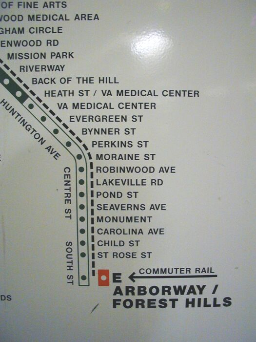
Trolley stops and bus stops literally are the same thing, since all of the major bus routes in town are ex-streetcar routes with stops that are for the most part unchanged in the last 100 years. Street-running was even worse for close stop-spacing, as the old Arborway map indicates:

e-map.jpg


The only reason the 3 reservations are slightly better than your average bus route is that 'stop consolidation' was a feature from Day 1 of the B, C, E reservations to make them seem more like express routes. Part of the whole ground-up planning of Huntington, Beacon, and Comm Ave. as wide urban boulevards.

The problem is nothing evolved with the times. Those platforms weren't adjusted around road construction that changed the whole nature of the corridor, and consolidation and re-spacing was pretty much blasphemy until the last 10 years when they did the first round of B consolidation. They can't even successfully implement it most of the time it's proposed on bus routes. The slightest pushback and a consolidation plan gets dropped. "We've always done it this way" is the rule. And so both the Green and Yellow lines are really, really creaking under a lot of legacy cruft where changing stops is way harder than it should be. Institutional inertia in the T, and provincial inertia in the city and neighborhoods. I wouldn't say any one party is necessarily at fault, though no one seems to want to take the reins and make themselves final arbiter.


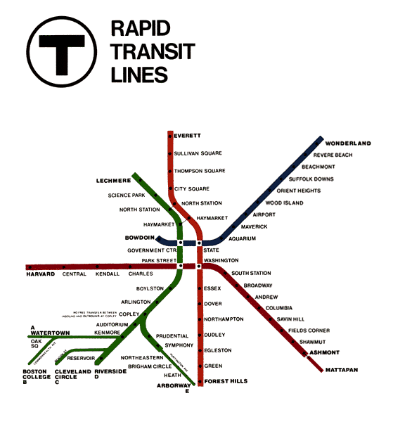
Ironically, the spider map may end up being their own worst enemy here. The iconic Cambridge Seven Assoc. spider map debuted in 1967, and for the first 22 years it only marked every stop on the heavy rail lines, and truncated the GL branches to show only the short-turn stops. Including on the D.

67mbta.gif


Later they added all the D stops to the GL-detail maps but still left B, C, E totally open to the imagination. See this street-detail 1980 system fold-out map: http://www.wardmaps.com/viewasset.php?aid=14827. B, C, and E are all blank. In their operating days Arborway and Watertown stops used to be marked by the side of the road by a red stripe painted on the nearest trolley pole, a practice leftover from how BERy used to mark stops at turn of the century. It was just as dodgy as systemwide bus stop signage was until the mass re-signing effort of the last 10 years.


Those hyper-detailed branch maps like that insane Arborway one shown above debuted with the 1989 system map, same year they added small trolley signage at the street-running stops. Before that re-signing effort there were still some B and C platforms that lacked any identifying signs whatsoever. That ended up more or less pouring cement over the routes by conditioning riders to treat every stop as fixed forever. Even the useless ones like Back of the Hill, which was in infill stop added to the 1989 schedule which never existed for all of history prior to that.


They're not exactly getting better about this with those ever-more complex maps lathering on all Silver Line surface stops and key bus routes. I get the motivation to convey as much detail as possible, but the shift towards treating non-fixed stops as fixed stops began as a late-80's PR excuse to explain away all the transit expansion and restoration commitments they were backpedalling from. Which in turn makes people that much more skittish about reconfiguring even basic bus stop spacing and reinforces more status quo.
 

Back
Top