Boston Harbor Flood Protection Projects

Washington Post, July 4, 2017
"Ancient Romans made world’s ‘most durable’ concrete. We might use it to stop rising seas."

quotes -
"The harbor concrete, a mixture of volcanic ash and quicklime, has withstood the sea for two millennia and counting. What's more, it is stronger than when it was first mixed."

"The Roman stuff is “an extraordinarily rich material in terms of scientific possibility,” said Philip Brune, a research scientist at DuPont Pioneer who has studied the engineering properties of Roman monuments. “It's the most durable building material in human history, and I say that as an engineer not prone to hyperbole."

"Modern sea walls require steel reinforcements; a future in which “large relic walls of twisted steel” dot the coast would be “very troubling,” Jackson said. The Romans didn't use steel. Their reactive concrete was strong enough on its own."

https://www.washingtonpost.com/news...t-to-stop-rising-seas/?utm_term=.5f07e1db609a

Just concrete sea walls are usually pretty ugly even if they do last decades.

Really big blocks of granite or even loose rocks work just fine if they are big enough. "Armoring" the coast lost favor for a number of years because of poorly designed coastal defenses that had the potential to deflect wave energy towards different shore locations and thus cause erosion in other places.

Though the solution to that, putting softer dunes with sea grasses in front of the rocky defenses seems pretty simple and straightforward.

EPA, DEP and local Con Coms should really come up with a simple set of regulations that don't involve multiple layers of permitting to just get coastal defense done. Just give prior approval for coastal defense that follows the guidelines rather than treat every project as a snowflake.

People live along the coast, we have infrastructure along the coast and we need to protect it if we want to continue to enjoy and utilize it.
 
https://twitter.com/Win4CBS/status/948977197926289409

https://twitter.com/NWSBoston/status/948974832577925121

https://twitter.com/Libjammin/status/948974865025064960

https://twitter.com/Libjammin/status/948974684862902273

Apparently there's a lot of water near portside in eastie too.

No word on the blue line.

And in 24 hours this is all going to be solid ice

Close to worst case scenario. All that's missing is the wind-driven flames when people try to create heat and light after the sun goes down.

Build the barrier....

Definitely has been really bad all along the Seaport. The water levels are just starting to recede, but there has been a lot of damage. +1 for building the barrier.
 
Aquarium is closed. I think BL may be suspended entirely due to Beachmont flooding. I think this flooding is an indication of what we'll experience more and more going forward. Build the barrier!
 
https://twitter.com/Win4CBS/status/948977197926289409

https://twitter.com/NWSBoston/status/948974832577925121

https://twitter.com/Libjammin/status/948974865025064960

https://twitter.com/Libjammin/status/948974684862902273

Apparently there's a lot of water near portside in eastie too.

No word on the blue line.

And in 24 hours this is all going to be solid ice

Close to worst case scenario. All that's missing is the wind-driven flames when people try to create heat and light after the sun goes down.

Build the barrier....

Blue Line is in very bad shape. Closed from Orient Heights to Wonderland due to flooding at Beachmont/Belle Isle. No substitute service. Aquarium is also being bypassed due to the flooding.

The Blue Line seems to be our weak point re: resiliency.
 
Blue Line is in very bad shape. Closed from Orient Heights to Wonderland due to flooding at Beachmont/Belle Isle. No substitute service. Aquarium is also being bypassed due to the flooding.

The Blue Line seems to be our weak point re: resiliency.

That's not bad. Bad is if seawater got into the tunnel and damaged equipment a la NYC. Closed because the tracks are washed out is a today problem (on a day when people aren't supposed to be moving). Destroyed tunnel equipment is a ten years problem.

But yes, today should be a wake-up call for people. Fortunately, Boston has plans for resiliency in place, but they need to be implemented.
 
I'd be really interested in knowing how much water is currently making its way into the Silver Line tunnel.
 
With respect to the flooding in the Seaport area, I'll guess that the storm sewer outfalls into the harbor either don't have tidal gates, or the tidal gates are frozen open. If the tide is high enough, and there is no functioning gate, the ocean will flow back through the sewer and overflow at a drain in the gutter, if the top of the drain is lower the height of the tide.

This tide is very close to the tide recorded in the Blizzard of 1978, so there is a reference point that should have guided the design of the Harborwalk to prevent splashover inundating the Seaport, even from a storm such as this.
 
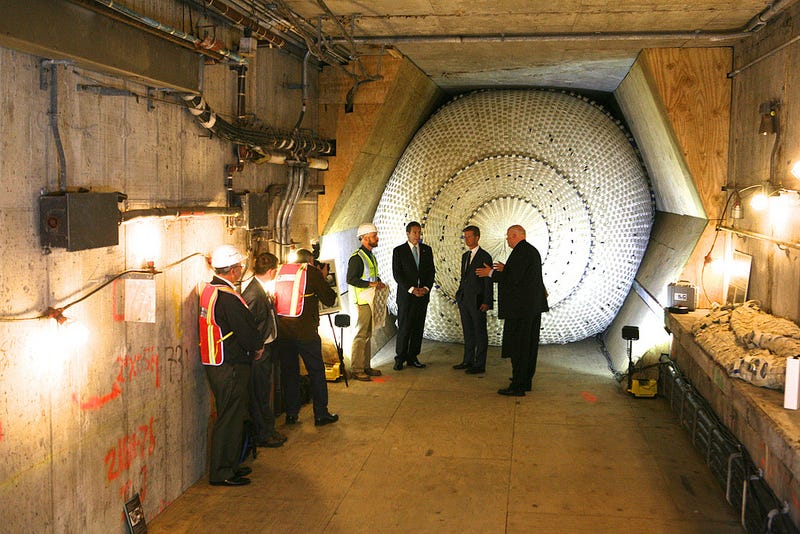
It would seem some tunnel plugs are needed:

https://gizmodo.com/nycs-first-inflatable-tunnel-plug-will-stop-floods-sm-1458290295

195c7hxin6sajjpg.jpg
 
The NWS has confirmed that yesterday's tide was indeed the highest ever since 1921, besting the Blizzard of '78 by 0.06'

[OFFICIAL] Boston has broken the highest ever recorded tide since 1921. New Record: 4.88' MHHW (or 15.16' MLLW) on January 4th, 2018. Old Record: 4.82' MHHW (or 15.10' MLLW) during the Blizzard of '78.

https://twitter.com/NWSBoston/status/949313785671667712
 
It would seem some tunnel plugs are needed
Definitely could use one on the downhill side of Aquarium, Maverick, & South Station, & Fenway

The picture included is a bit cheat-y: where do the tracks go? The deeper article says the stopper has extra fold to fill around things like wiring conduits. IN the picture, they've made a hexagon by encasing a lot of tunnel hardware and edges in those plywood wedges. (Floor seems plywooded too, in the Gov Cuomo photo)

Presumably they also have to change the trackbed (no ballast for water to sneak through), and have a gap in 3rd rail, and maybe even with smooth rubber floor. What do they do to allow it to plug where the wheel flanges go? Is that slack just like around conduits?
 
Last edited:
...well, there are pumps in the tunnel, so it doesnt need to be 100% watertight...just needs to staunch the flow for a few hours at high tide...

also, sandbags for the headhouses. I hope someone is taking a close look at the aquarium elevator before it goes back in service...
 
Honestly it cleaned up a lot better than I expected. I don't think the flood barrier in the harbor is cost effective compared to just building up the existing walling 5 ft or putting down sandbags when we know storms are coming.
 
I read a report from Gloucester (60 cars were totaled by the sea and ice in the high school parking lot) where a woman complained that the tide came up into her toilet. (Would be a combined sewer and the toilet, probably in the basement) was below the height of the tide. Water seeks its own level.)
 
Nice work by Barr Foundation that shows the access points at which the tide flows into various neighborhoods (implies short term solution may be berms at vulnerable points)
https://www.barrfoundation.org/blog/from-planning-to-action-preparing-boston-for-a-changing-climate

That mentions the possibility of a deployable flood wall across the East Boston Greenway.

Is the elevation of that greenway significantly below mean high tide? If not, would building a permanent berm near the west end of the greenway be an option? If a berm across the greenway 10' higher than its current elevation would be an adequate flood barrier, a ramp with a 10' elevation change can be less than 200' long on each side. I don't know if a permanent structure would be more reliably watertight than a structure that would have to be manually installed when it is anticipated it might be needed.
 
The picture included is a bit cheat-y: where do the tracks go? The deeper article says the stopper has extra fold to fill around things like wiring conduits. IN the picture, they've made a hexagon by encasing a lot of tunnel hardware and edges in those plywood wedges. (Floor seems plywooded too, in the Gov Cuomo photo)

Presumably they also have to change the trackbed (no ballast for water to sneak through), and have a gap in 3rd rail, and maybe even with smooth rubber floor. What do they do to allow it to plug where the wheel flanges go? Is that slack just like around conduits?

If you're willing to put significant labor effort into installing the plug, simply removing a few hundred feet of track and third rail and ballast may be an option. (My understanding is that when the Susquehanna bridge has to be opened to let a boat through, Amtrak sends a few dozen track maintenance workers to deal with everything that is involved in that process, and that bridge opens an awful lot more times than a tunnel plug would be needed.)

However, if raising the vulnerable headhouses by 10' will eliminate the need for the tunnel plugs, I'd be happy to see the focus be on fortifying the headhouses.
 

Back
Top