You are using an out of date browser. It may not display this or other websites correctly.
You should upgrade or use an alternative browser.
You should upgrade or use an alternative browser.
- Joined
- Dec 10, 2011
- Messages
- 5,599
- Reaction score
- 2,719
^ This encourages me to feel "on schedule" in the sense that in order for the next phase of construction to start, they need access to the final grades on which the tracks and signals will get laid down.
"Access to the final grades" has two elements:
1) transversewise, the "floor" needs to be pushed all the way back to the base of the final retaining wall,
2) longitudinally, the linear running needs to be able to run alongside the future stations (or the stations need to be "done enough" to allow the tracks to be laid)
And it sure looks to me like we're a month away from that being so (except at Gilman and Tufts, which the schedule says will lag the others)
It's no longer on their site, but I seem to recall FOTCP's alternative path design included a lower crossing of the Fitchburg Line on a prefab truss bridge, then crossed under the GLX next to the Fitchburg at ground level. Of course, by the time the project was re-bid, some of the supports for the higher crossing had already been built.
Of course, the grade is going to exacerbate the other problem with the path, which is that it's really narrow by modern design guidelines for the anticipated traffic loads.
I think the new GLX did not reuse those structures in the redo version of the CPX.
RandomWalk
Senior Member
- Joined
- Feb 2, 2014
- Messages
- 3,793
- Reaction score
- 6,817
It’s surprising how quickly the southern wall on the Central-Sycamore block came together.
HBH
Senior Member
- Joined
- Apr 17, 2018
- Messages
- 1,564
- Reaction score
- 4,750
citydweller
Active Member
- Joined
- Aug 23, 2019
- Messages
- 486
- Reaction score
- 766
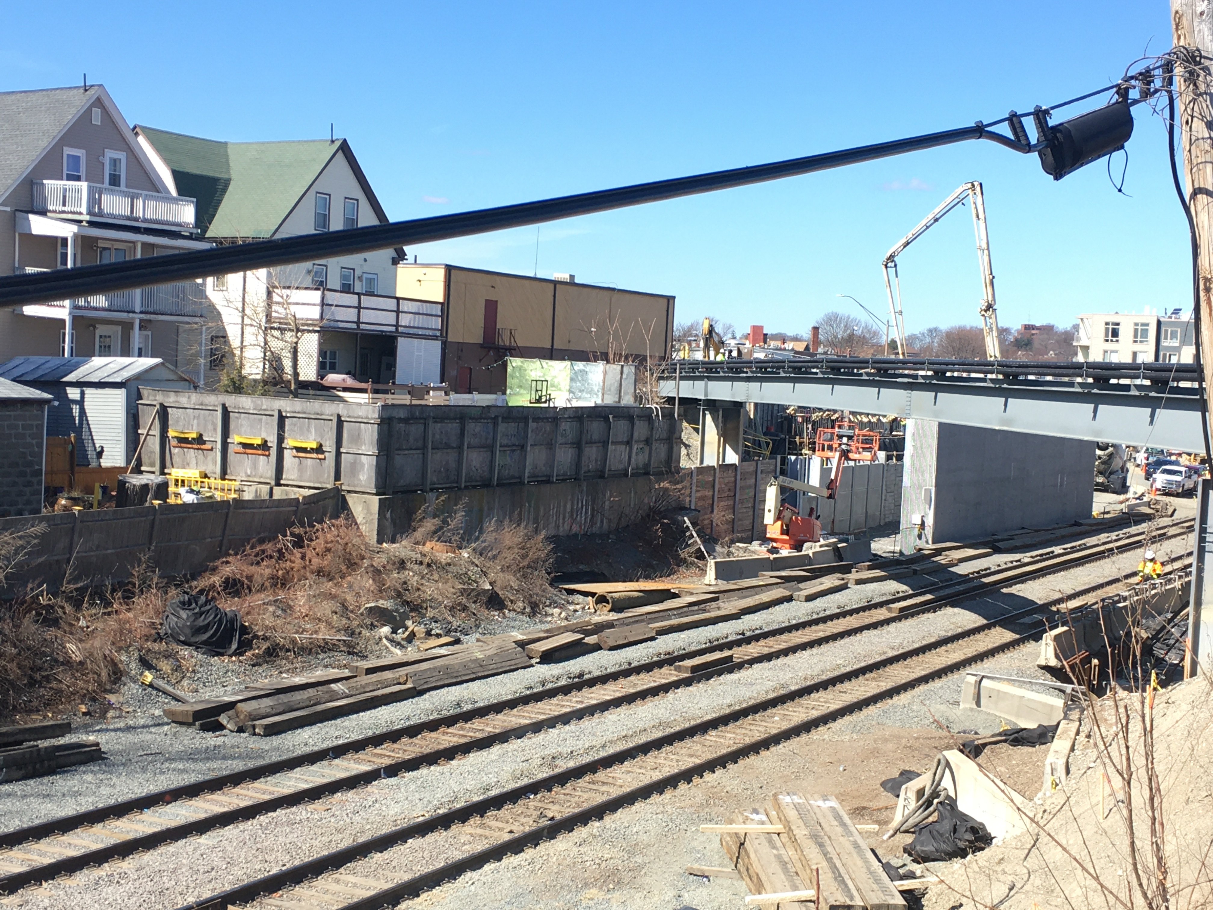
Ok, this has been bugging me. Admittedly, I'm a neophyte regarding this project but what is that structure and isn't that smack-dab in the middle of where the new tracks are going?

That would be Gilman Square Station and the tracks will go on either side of it. Outbound roughly just inside where the temporary concrete barriers are and inbound between the island and the retaining wall. Here's a quick overview.Ok, this has been bugging me. Admittedly, I'm a neophyte regarding this project but what is that structure and isn't that smack-dab in the middle of where the new tracks are going?
- Joined
- Dec 10, 2011
- Messages
- 5,599
- Reaction score
- 2,719
Smack dab in the middle = smack between, like many bridge supports.
At both Gilman and Ball Sq the inbound GLX is being routed behind an existing bridge abutment where the dirt has been mined out behind it, and a small span will bridge between the old abutment and the new retaining wall
At both Gilman and Ball Sq the inbound GLX is being routed behind an existing bridge abutment where the dirt has been mined out behind it, and a small span will bridge between the old abutment and the new retaining wall
Surprised they didn't finish the retaining wall while the crane can fit easily.Ok, this has been bugging me. Admittedly, I'm a neophyte regarding this project but what is that structure and isn't that smack-dab in the middle of where the new tracks are going?
View attachment 7172
Great to see the platform foundations going in along this stretch. Can you imagine how much longer this would take with the original 2-3 story stations?
ceo
Active Member
- Joined
- May 4, 2009
- Messages
- 668
- Reaction score
- 920
Tiny little correction: they're doing this with the Medford St and School St bridges, on either side of the Gilman Square station. The Ball Square bridge was torn down and rebuilt from scratch, but it also has a pier between the inbound and outbound GLX tracks. I'm guessing they put it there because a central pier would be in the way of the outbound track as it shifts to the center approaching the station.At both Gilman and Ball Sq the inbound GLX is being routed behind an existing bridge abutment where the dirt has been mined out behind it, and a small span will bridge between the old abutment and the new retaining wall
- Joined
- Dec 10, 2011
- Messages
- 5,599
- Reaction score
- 2,719
^ Thanks for the correction on Ball Sq. Here's an earlier picture by Javier that shows that Ball Sq has a "clearly new" smack-dab pier (the uniform corduroy finish indicates it is new) between the inbound and outbound sides of the GLX. Essentially at Gilman, they're re-using the abutment and spans of the pre-existing bridge, but adding an extra "bay" to them.
- Joined
- Dec 10, 2011
- Messages
- 5,599
- Reaction score
- 2,719
CEO also called this one correctly:
They have, in fact, replaced (or augmented?) the timber retaining wall with a wall of pre-fab panels similar to those elsewhere on the raised grade of the the GLX/CR tracks between Titan Gas (Boston @ Harvard St) and Tufts' eastern reaches.It looks like there's juuuuust enough width to squeeze the inbound track through [ the "back way out" of the Titan Gas car wash b(https://goo.gl/maps/amDpjepRHMER2uR79)], but they'll probably want to rebuild that timber retaining wall.
Last edited:
RandomWalk
Senior Member
- Joined
- Feb 2, 2014
- Messages
- 3,793
- Reaction score
- 6,817
Ironically, the pre-1970’s Broadway bridge crossed a full 4 track ROW. The 1970’s replacement buried one of the old abutments behind its replacement, and that slowed the work on the new one.


RandomWalk
Senior Member
- Joined
- Feb 2, 2014
- Messages
- 3,793
- Reaction score
- 6,817
They are really designing the bike path to give people a good cardio workout. Has the design team explained why it’s such a roller coaster?
ryblogs
New member
- Joined
- Aug 22, 2017
- Messages
- 64
- Reaction score
- 85
It was a"budget add-on" that had to be added in the cheapest way possible, or not at all. At least they are doing itThey are really designing the bike path to give people a good cardio workout. Has the design team explained why it’s such a roller coaster?
They are really designing the bike path to give people a good cardio workout. Has the design team explained why it’s such a roller coaster?
TBH, while the Minuteman has lots of bikes moving at high speed, the Somerville community path with all it's winding has always been more tailored to pedestrians. While a "bike-highway" to downtown would be great, this isn't that. I'm picturing lots of walkers, bluebikes, Escooters and light-commuters catching the nearest train, like Somerville's existing demographics do. The ABILITY to give bikers a safer commute should make up for the slower safe-speed expectations.
TBH, while the Minuteman has lots of bikes moving at high speed, the Somerville community path with all it's winding has always been more tailored to pedestrians. While a "bike-highway" to downtown would be great, this isn't that. I'm picturing lots of walkers, bluebikes, Escooters and light-commuters catching the nearest train, like Somerville's existing demographics do. The ABILITY to give bikers a safer commute should make up for the slower safe-speed expectations.
Yeah, it feels like this will be part time a commuter route. And really for most of the rest of days of the week a way for people to get off of busy/noisy local arterials and stroads for a nice walk around the neighborhood or perhaps a quieter way to get to and from specific destinations like City Hall or the high school that is off-street. Also, like the paths by North Point Park a weekend destination.