MBTA "Transformation" (Green Line, Red Line, & Orange Line Transformation Projects)

View attachment 14097
What I see in this rendering (E Line street running) is moving the tracks to the outside lane; narrow unprotected bike lane between the tracks and car center thru lanes. Looks like death to cyclists time.
Just a note on this, they added a caption footer to these images in the final deck that was presented today saying "example from early conceptual renderings." Seems like someone saw all the fuss on Twitter and edited the slide. In the meeting, he emphasized that these images were just very early preliminary studies and they will be working with all agencies and stakeholders (BTD, cyclists, abutters, community, etc) going forward to shape what this ultimately looks like.

You can view the livestream archive here: https://www.mbta.com/events/2021-06...d-and-the-fiscal-and-management-control-board
GLT presentation starts at 3:07:00
E Branch is at 3:12:00


1624319049896.png
 
*Theoretically* you can whittle the existing system down to just -one- in-street stop. Assume Fenwood + BoTH are goners for beneficial stop consolidation. If you got the City and BHA to voluntarily cede the front one-way wraparound driveway of Mission Park Apartments to a widening of Huntington, it would be possible to make the reservation fully reappear for the Mission Park stop...spanning the St. Albans Rd. to Mission Park Dr. block, signal-to-signal. Huntington averages 87-90 ft. wide curb-to-curb on the reservation section east of Brigham Circle, and is 60 ft. wide curb-to-curb on the Mission Park block. You can achieve 90 ft. width (and thus, all of the width for a reappeared reservation, any platforms on the reservation, and on-street parking on both sides) by going existing EB curb to the inner Mission Park sidewalk curb fronting their driveway. It's a net loss of 7 handicapped spots @ the Apartments that would need to be given priority accommodation elsewhere on the apartments site, and 16 general resident spaces which should not be at all difficult to re-accommodate scattered into nooks and crannies on the backside of the property. The wraparound itself, being an extreme-narrow one-way, is kind of superfluous. All told if BHA were strongarmed by 'a' Mayor's office to find onsite relocations for 23 spaces with orders to prioritize the advantageous placement of the 7 displaced handicap spots...they could do it in their sleep here. And then you'd have trolleys drifting mid-traffic for exactly 2 blocks, before turning back onto the reservation at a full-featured Mission Park reservation stop...and only have to worry about "San Francisco'ing" Riverway as a one-time in-street kludge.

Of course, this is Boston, where City institutions abhor playing nice with State institutions because "Fuck you"...so extremely feasible solutions for both the streetscape and the apartment-dwellers don't stand a chance of happening amid the clash of political fiefdoms. But if we had a Prospective Mayor who wanted a "Mr./Ms. Fix-It" demonstration project of pressuring a consensus on said warring institutions, this honestly would be a pretty nice test case. I don't get that impression from any of the current crop of candidates that they're thinking on how to granularly set aside some petty internal-political squabbles for the greater good, but bygawd it's there for the taking and easy enough if any of them want to go for it.
 
I thought that both stations would be completely done. Looks like it'll be in stages. Hope that they can get it all done before the winter. If not, we won't get to see them be reborn until next year. :unsure:
 
Last edited:
I can't really articulate why, but the canopy design doesn't make me think Boston. For one reason or another, it reminds me of Southern California, as if it were lifted from a station on Crenshaw or some other LA metro station.
 
I can't really articulate why, but the canopy design doesn't make me think Boston. For one reason or another, it reminds me of Southern California, as if it were lifted from a station on Crenshaw or some other LA metro station.
I am having the same disconnect.
 
I can't really articulate why, but the canopy design doesn't make me think Boston. For one reason or another, it reminds me of Southern California, as if it were lifted from a station on Crenshaw or some other LA metro station.
Yes, and I'm not clear on why, either, especially because I can't think of any surface level stations in L.A. that actually look like this. Nevertheless....
 
I can't really articulate why, but the canopy design doesn't make me think Boston. For one reason or another, it reminds me of Southern California, as if it were lifted from a station on Crenshaw or some other LA metro station.
I agree. Also similar to the new North Washington Street Bridge as something lifted from California or Florida.
 
Perhaps it's something that was discussed here before; that the shelters look like they're designed more for shade rather than protector from precipitation?
 
Maybe it’s just that it is modern (and we aren’t used to 21st century design)
I don't think it's quite that; I haven't heard not do I myself have any similar sentiment towards any of the GLX canopies or Chelsea. Something about the design of these canopies makes me think in a location agnostic render they'd look very at home surrounded by palm trees. Basically, S Florida, So Cal... It's something about the look, and it's not just the fact they're new and white.

Edit: I spent far too long digging through LA Metro documents and social media. I think I've finally isolated the most similar SoCal station. Meet Westchester/Veterans, on the under construction Crenshaw Line.
20210708_235921.jpg

LA metro apparently standardized their canopy parts bin in 2012, and so anything new shares a similar design language. They do look good in renders with lots of palms...
losangelescountymetrocrenshawlaxcorridor2-7186.jpg
Metro Crenshaw LAX Downtown Inglewood Station.jpg
 
Last edited:
I can't really articulate why, but the canopy design doesn't make me think Boston. For one reason or another, it reminds me of Southern California, as if it were lifted from a station on Crenshaw or some other LA metro station.


I hear ya, but it's still not as jarring as the metastasizing Houston blue glass pandemic.
 
I like the canopy design, I think it looks modern and clearly visible from a distance. A good advertisement for the T,

What I hate in the first picture is the absolutely idiotic use of a shoulder, which makes 4 feet of the ROW completely useless. Could have been a nice row of trees.

Thanks highway traffic engineer!
 
What is with the tarf that's still on the track beds? It makes them look tacky & raggedy! And what is taking them so long to finish those station platforms anyway? Looks like they've stopped al together & closed up shop! :(
 
Last edited:
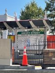
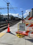
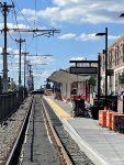
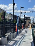
Hey folks, first post on aB but have been following the site for a few years now. I took some photos today of the new Amory street station on the B line - they have the emergency call kiosks up as well as the dot matrix screens. Also, I've seen the new rapid transit system map with the Green Line Extension before (from pictures of Ruggles) but this is the first I'm seeing the green line map specifically with the new stations on the D and E lines (first image below, to the right of the system map). Pretty cool.

IMG-1569.jpg IMG-1570.jpg IMG-1571.jpg IMG-1572.jpg
 
"Park Street and North" - I prefer "eastbound". The way they draw the map makes it seem like the green line is going north to the west as well
 

Back
Top