North Bank Bridge Pedestrian Walkway

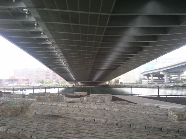
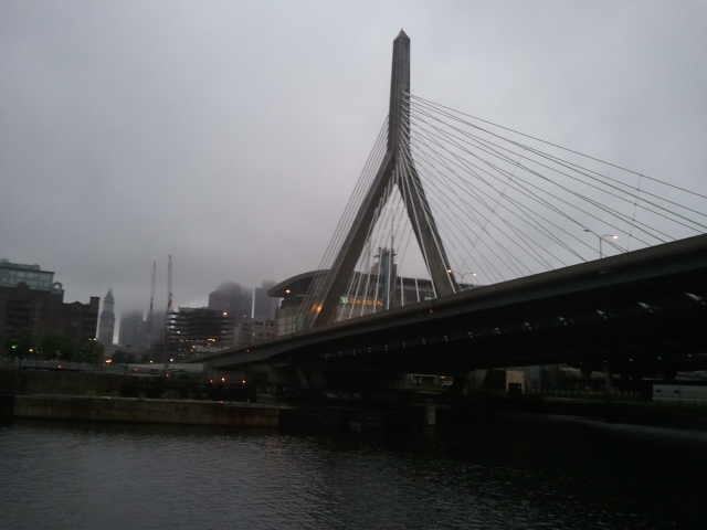
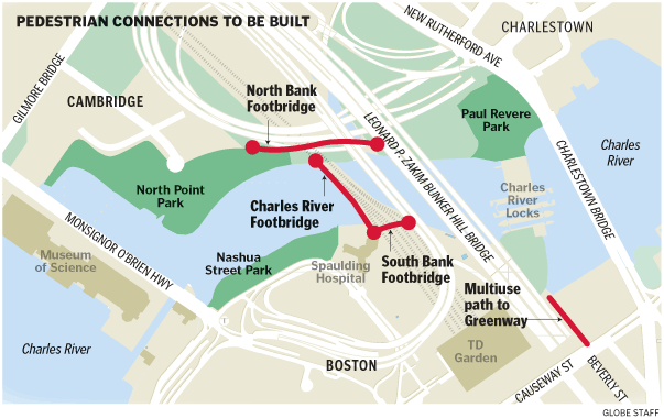
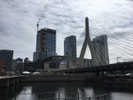
You can now once again walk or bike between Lovejoy Wharf (Boston end of the Charles River Dam) and the TD Garden, passing under the Zakim Bridge. The temporary fences in this area are gone.

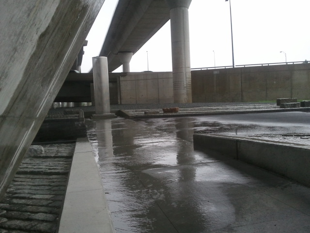
Unfortunately, the section of Harborwalk next to Lovejoy Wharf, leading to the walkway under the Charlestown Bridge, is still fenced off. I do not understand why the state has allowed the developer to do this.

While we're on the subject, will the city or state ever do something about this part of Beverly Street, leading to the dam? I don't begrudge the State Police Marine Division their parking lot, but the mess of orange barrels and Jersey barriers really needs to go away. While we're at it, either pave or landscape (or some of each) the dirt area now used as a parking lot extension. This should be a grand gateway for pedestrians, but right now it looks like the Big Dig never ended.
 
This bridge to the park under the Zakim bridge is awesome!! Reminds me of of a bunch of raves I went to under a bigger bridge in Osaka, Japan.

2012-08-10%252017.41.36.jpg


2012-08-10%252018.23.45.jpg


2012-08-10%252018.22.03.jpg


2012-08-10%252018.07.50.jpg


2012-08-10%252019.09.01.jpg
 
There are similar structures under the Zakim on the Boston side of the Charles, between the TD Garden and Charles River Dam. I'm not really sure what these are supposed to be ... and I wonder if they will be used as an interim skateboard park before the real one is built.
 
The path under the North Washington Street Bridge has been closed for at least a couple of years. A DCR Ranger told me that a worker had been killed while trying to repair the building overlooking Lovejoy Wharf and that there is a lawsuit that has kept the building owner from repairing the masonry to keep bricks from falling off.
On the other hand, just one look at the decrepit state of Lovejoy Wharf has me second guessing what I was told.
 
Is there any indication when construction will begin on the south bank bridge over the north station tracks?
 
As you probably know, there were three bridges, in addition to the parks, that were promised as part of the Big Dig: the North and South Bank bridges and also one over the Charles, adjacent to the rail bridge. Cost overruns consumed the funds for all three... I don't think there is any concrete plan for either of the other two bridges. We will probably wait the longest for the one over the river since it needs to be a drawbridge....
 
As you probably know, there were three bridges, in addition to the parks, that were promised as part of the Big Dig: the North and South Bank bridges and also one over the Charles, adjacent to the rail bridge. Cost overruns consumed the funds for all three... I don't think there is any concrete plan for either of the other two bridges. We will probably wait the longest for the one over the river since it needs to be a drawbridge....

The one across the river will probably be done in tandem with a rebuild of the rail draws. But yes, that will take the longest.
 
I know this thread is quite old at this point, and related to the North Bank Bridge specifically, but I'm interested in the mirror image South Bank Bridge. This is about the only mention of it on AB.

The North Bank Bridge has been open for some time now, and it's phenomenal. The skate park just opened, so we'll see how everything goes there, but I don't think it'll be an issue. However, living in the North End and using the Charles for running, biking (including commuting to the Longwood area), and strolling, it's the south bank that lacks the connectivity I'm after. Having a dead end on both sides of the train tracks is just frustrating, particularly when heading east.

I've searched high and low for information on this, but I've come up dry. I just re-read this item: http://www.bostonglobe.com/magazine...ture-boston/pJYNmRChTihtRrDiszGWmJ/story.html

"Two more footbridges, one spanning the Charles, and a more complex structure that would leap over the railroad tracks adjacent to the Spaulding Rehabilitation Hospital, are in design, with funding in place to complete them by 2015, according to the Department of Conservation and Recreation. They’re not yet a done deal, but if these two bridges are built as planned, they and the new North Bank Bridge will allow cyclists and pedestrians to move almost seamlessly among the Esplanade, the Rose Fitzgerald Kennedy Greenway, and Boston Harbor, whether they’re riding from Cambridge, the North End, or Charlestown. “

Obviously, 2015 isn't happening. But, is anything?
 
ARRA funding built the North Bank bridge, but that temporary source of federal funds is finished. The other ped bridge projects are unfunded at this time, as far as I know.
 
I know this thread is quite old at this point, and related to the North Bank Bridge specifically, but I'm interested in the mirror image South Bank Bridge. This is about the only mention of it on AB.

The North Bank Bridge has been open for some time now, and it's phenomenal. The skate park just opened, so we'll see how everything goes there, but I don't think it'll be an issue. However, living in the North End and using the Charles for running, biking (including commuting to the Longwood area), and strolling, it's the south bank that lacks the connectivity I'm after. Having a dead end on both sides of the train tracks is just frustrating, particularly when heading east....

"Two more footbridges, one spanning the Charles, and a more complex structure that would leap over the railroad tracks adjacent to the Spaulding Rehabilitation Hospital, are in design.... if these two bridges are built as planned, they and the new North Bank Bridge will allow cyclists and pedestrians to move almost seamlessly among the Esplanade, the Rose Fitzgerald Kennedy Greenway, and Boston Harbor, whether they’re riding from Cambridge, the North End, or Charlestown. “

Obviously, 2015 isn't happening. But, is anything?

PBones --- are you a long-term visitor [i.e. student-type status] or are you a semi-permanent resident

If you are the former -- prospects are dim to dark as there will be no money for new projects for the next few years

If you are the latter -- then just Keep Calm and Stay Patient

keep_calm_and_carry_on_union_jack_mini_poster_raw.jpg


-- while costing M$s there are the kind of projects for which there just might be a light somewhere at the end of long and longer tunnel as Boston gears up for the quadricentennial in 2030
 
I agree that the lack of connectivity on the south bank is really frustrating. I think it was also a missed opportunity that the city didn't push for it as a concession with the Avalon North Station or TD Garden projects. Maybe the developer doesn't pay for the entire cost but they could at least contribute some money.

Somerville seems to be much more proactive about extracting community benefits from developers. They were able to push Federal Realty to pay for the pedestrian bridge under 28, the new OL stop, new park, etc.
 
They're not going to do "South Bank" until the USPS relocation gets un-stuck. Not because of any project/construction or funding dependencies with SSX, but because the would-be bridge's utilization is crippled until Dot Ave. becomes a thru street again. And there's no starting point for Dot Ave. becoming a thru street again until the feds can get their house in order.

Since a Post Office relocation takes an act of Congress...that decision is beholden more to the Capitol Thunderdome's productivity level or lackthereof than it is real, substantive funding hang-ups. May be another session and/or 2-3 more human sacrifices at House Speaker before that bill makes the floor. The state/city/BRA may have bungled some earlier opportunities to lock it down, but at least until Jan. 2017 if not Jan. 2019 Congress is probably going to be too distracted by its own internal chaos to bring any best offer the locals make out of committee for a look-see.

So there's no point even circulating some pretty renders of a footbridge to the public when next action item is stuck in a rut at the national level. I'm sure they've got a whole folder full of concepts for it...but there's no point advancing it to a funded stage of prelim design when they can't pin what calendar year--or decade--they can feasibly get that Dot Ave. block open to the public. It could be funded out of its own sources decoupled from anything SSX related, but their sales pitch for seeking such funding is dependent on what they can claim as a timetable for reopening Dot Ave. If the USPS stalemate thwarts any such time projection, they're going to have zero shot for so much as advancing the design funding.

Therefore, ends up better in the short-term to just bunker in and keep their concepts for the bridge quiet until there's something they can act on re: USPS. If a deal gets struck, then they can pounce and start showing renders when attention is going to be at its highest and design funding can likely be made available in the coattails from that relocation deal.
 
F-Line, the South Bank bridge would go over tracks near North Station on the "south bank" of the Charles, not at South Station.

Your analysis is spot on re: SSX, but this is a different project.
 
F-Line, the South Bank bridge would go over tracks near North Station on the "south bank" of the Charles, not at South Station.

Your analysis is spot on re: SSX, but this is a different project.

Right. We were supposed to get three bridges but due to big dig cost overruns, none got built and we finally, years later, got one of three. Other two are the south bank bridge which could go over the tracks and under the zakim, and a pedestrian bridge next to the railroad drawbridge (they actually built a walkway out to the draw portion of the bridge). The latter bridge is not as critical since you can cross by the locks, but certainly would be an improvement even though I doubt it will be built soon, if ever.

The city and MBTA and state should be thinking really, really hard about the MGH parking lot and old Spaulding building to figure how to eventually expand north station, extend the riverwalk on the south bank, and built that damned bridge. Talk to MGH about their 20 year plan and get some ideas on the books now.
 
There's a bit of confusion over where the south bank ped bridge would be so here is a map I found.

globegiftastic__1258703605_9990.gif
 
I'm not sure how that South Bank bridge would work with such short ramp approaches.
 
The multi-use path to greenway is supposed to be built by the Lovejoy Wharf Developer according to what I was told at Connect Historic Boston meetings. So we should be able to expect that to be complete by next summer.

Not shown in that diagram is the cantilevered walkway on the east side of the drawbridges. I know that the drawbridges are planned to be replaced soon, but haven't heard anything about them in almost two years.
 
There is behind-the-scenes work going on to plan for the drawbridge replacements. I would not expect to see any real work until the Silver Line Gateway project is complete, including the second phase with the direct transfer to the new Mystic Mall station. That gives three of the four lines direct rapid transit transfers, which will help with load-spreading.

They'll replace one drawbridge at a time; if they do a little weekend-blitz interlocking rejiggering, they might be able to have each serve 6-8 tracks during the closures. The two-track draw is a pinch, but with proper scheduling - and two of the four lines having infrastructure improvements wrapping up that will improve schedule reliability - it's probably doable to maintain near-current schedules.

I've hear rumors that they may attempt to put two trains on some platform tracks at some times. That'll be an ugly and difficult to pull off, but interesting to see. I wouldn't be surprised if they did a few temporary wooden platform extensions to allow more cars to platform, and pulled some bilevel cars northside to make for shorter trains.
 
I got to check out the North Bank footbridge for the first time. Great piece of engineering and design, nice planning of the whole area.
Thank you for the photo essay! It really is a great model for what public infrastructure can be.
 

Back
Top