Underground station layouts

Any requests for what's next? As far as underground stations, options are:
  • Alewife
  • Porter
  • South Station
  • Broadway
  • Andrew
  • Shawmut
  • North Station
  • Government Center
  • Just do State already, you damn coward
  • Chinatown
  • Tufts Medical Center
  • Back Bay
  • Ruggles through Forest Hills
I am planning to do the non-underground heavy rail stations (and GLX) as well.
 
As requested, Government Center. The former Court Street station area is very speculative, and largely based off a handful of 2014 photos and a later-modified 1903 plan. Most of the former station area is now occupied by the Blue Line tunnel, the roof of which leaves enough room to walk on.
Government Center.png
 
Brattle Loop is a fascinating little nook when it's open for short-turn revenue service after Garden events.

1024px-Brattle_Loop_looking_towards_abandoned_platform%2C_December_2017.jpg


There's a lot of platform back there. It opens up big after the second false-wall utility room jut in the above pic (the one by the bright light fixture). Behind that to the right you've got a big waiting area, original glossy BERy white-tile wall, empty ad frames on the wall that haven't been regularly used since 1964, and nooks to the deleted exits back there from back when Scollay Square still had a non-nuked street grid to send multiple entrances to. I've gotten off there a few times on Garden turns and always loitered on-platform as long as possible to check the place out. This should see some renewed revenue activity when GLX-Medford needs rush hour short-turning augmentation for service reliability on its constituent Riverside and Medford halves in lieu of the D plowing all the way thru end-to-end at peak loading. And if Urban Ring LRT ever happens this is the probable downtown turnback for the northern quadrants after they feed into Lechmere. They can do a lot of nice things with this space in the future. The two jutting utility rooms in the foreground are both expendable false walls, and nearly all of the left wall dividing it from the inbound platform is false-wall that would create cavernous new space on that end of the wedge. All a matter of "when" it's time to take the cinderblocks down and pull this back into an integral part of the station...not "if".
 
Does anyone have a map(to scale) of Sullivan Sq. I know its above ground but that highway makes it really hard to figure out
 
F-Line, the Brattle Loop platform looks great and can be enlarged as you say. The only concern I have about it is that it's on the north side of the station, requiring passengers to walk across the track to get to it. Is this generally allowable on the Green Line?
 
F-Line, the Brattle Loop platform looks great and can be enlarged as you say. The only concern I have about it is that it's on the north side of the station, requiring passengers to walk across the track to get to it. Is this generally allowable on the Green Line?

When it's open for Garden inbound short-turns you absolutely can walk across; it's no different from the Park St. grade crossing for crossing the island platform to hit the side egresses, Winter St. concourse, and T Underground store. See in the pic that there's one provisioned Brattle grade crossing a few feet out by the second support beam; another is right where the photographer is standing (see where platform lip starts to shave down in front of the open utility room door). With ADA'd platforms they'd taper the raised platform slope down just like the Park crossing to corral passengers through.

The biggest overall space gain would not be from the platform space to the right of the Brattle track, but simply demoing the cinderblock wall so the regular inbound side has several more feet of breathing room. The Blue stairs over there pinch the inbound platform in spots, making crowding a little hairy during delay recovery and REALLY hairy during City Hall Plaza events. Giving it back the extra 4 ft. of platform width on the Brattle side of the wall would do a lot of good for opening the inbound space back up, and ease the standee conflicts around the Blue stairs at max crowding. In the absence of any substantial daytime usage of Brattle Loop, that would just mean that the opening-up of the (large) platform space to the right of the loop track probably has its most immediate upside renting out space to more retail pushcarts. Have, say, 3-4 carts set up there and convert a couple of the nooks on that side that used to lead to long-demolished exits into after-hours storage closets for the cart goods. The greater oppenness of the station after the cinderblock wall is down will encourage passengers from all sides of the wedge to come visit. And the station, which already looks spectacularly more open post-renovation, would get a lot more so with the wall gone.

I mean...there is a LARGE amount of space back there. Space designed to be part of a revenue station and doesn't hide anything dangerous, so there was no good reason to wall it off in 1964 other than that it reduced the excess square-footage maint responsibilities for the revenue station at a time when budgets were impoverished, ridership was free-falling, and crowding was less a problem than ever. At 2020 passenger loading they arguably need it just for the extra breathing room to stand, apart from any Brattle Loop service usage. The way ADA platforms are raised people aren't going to be milling accidentally in the track area; if people are well-behaved at used the designated grade crossing on the Park island track with the extreme traffic levels there, the Brattle track will never be a safety issue. Large platform expanses are easily kept safe in the security cam era. And a simple flashing light/audible warning device of incoming Brattle Loop train (because it can happen at any given moment for pulling a disabled train) is enough warning for people on platform unaccustomed to seeing train movements on that track.


If Brattle Loop is needed for Medford crush augmentation so more inbound D's can be cut at GC rather than run thru in congestion, don't expect it to be a particularly busy service pattern. They might only need to do it every other D/Medford train only on the most overloaded couple hours of AM/PM rush to keep the system from getting over-brittle on end-to-end schedules. The only time you would ever see all-day service established there is with the Urban Ring converging at Lechmere, as there won't be enough capacity to send all northern patterns thru to Park St. and some Ring patterns like Kendall-BU or run-thrus to West/Harvard Branch would have their Red transfers covered by other means. As above, the reasons for taking down the wall are driven a lot more by considerations for more space on the thru-service inbound platform and drawing extra amenities revenue while the station is packed. Medford service (or rather, the main thrust of cresting Medford demand 2-5 years after Opening Day) is merely the convenient trigger for tearing down the wall and renovating the space because it will likely need to be put in part-time service at least 4-6 total hours per day at least every other D/Medford headway for managing peakmost loads.
 
Last edited:
Lansdowne, minus the stairs that are being relocated by Fenway Center. And a zoom-out that shows why a Kenmore-Lansdowne ped tunnel will never happen. Because of the angle, it would be a quarter mile long, and would likely have bends that make visibility/security more difficult. (Even a highly unlikely Copley-Back Bay ped tunnel would be shorter and straight)

Lansdowne.png
Lansdowne and Kenmore.png
 
Can't find any modern pics of the Brattle Loop platform anywhere online, but to orient self. . .

1898, looking from opposite end of the loop platform to the curve where the photographer in the modern shot is standing. The steel beams on the right are the once-open island platform encompassing the current inbound side; the cinderblock false wall covers that over. Platform on the left is the loop platform, with the former egresses to long-deleted streets visible. Loop platform, being unrenovated, is shorter most GL platforms but berths a 2-car train just fine. The thick "Y" beam supports on the left are the most architecturally distinct part of the old station; they start after the curve with the first one out-of-view in the modern pic. The glossy white BERy tile on the wall is still there, though it appears the incandescent lighting (generic 1940's bowl fixtures trackside, bare bulbs over the platform presumably because the diffusers were long ago raided for parts) has been replaced with fluorescent during the recent station reno.

1024px-Scollay_Square_Brattle_Loop_platform_2.png


Even if you erected a thin fence along the platform edge to the right with unlockable gates at grade crossings for the rare times the loop is in-service, the extra 4+ ft. of breathing room on the existing inbound platform from knocking down the false wall would be much welcome.
 
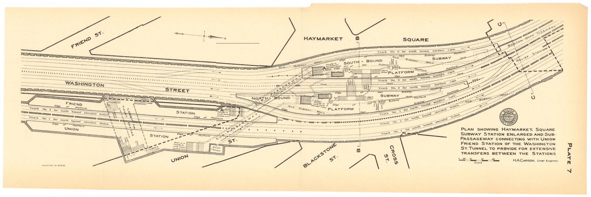
Belated question for you,EGE. The light green sections of the Haymarket GL...is that the old station? I know Haymarket and NS stations are pretty close....does anyone know how far the northern end of the old station is from the southern end of NS?
PS Do NS, do NS!:)
 
Belated question for you,EGE. The light green sections of the Haymarket GL...is that the old station? I know Haymarket and NS stations are pretty close....does anyone know how far the northern end of the old station is from the southern end of NS?
PS Do NS, do NS!:)

haymarket-png.4331


Yup...light-green stuff at the top is the old station. Once upon a time used to be 4-track, twin-island...with claustrophobically narrow platforms.

Guesstimating, NS is about 1100 ft. away. That's comparing old pre-'04 portal and temp El ramp locations from Historic Aerials with the Orange bunker, the BERy blueprints, and then rounding up to the nearest hundred for the post-'71 Haymarket being relocated further from the portal behind the old stop + the new tunnel adding a few tunnel feet in curve. (Google present-day isn't all that useful for measuring because of all the new overhead construction.) Crow-flies it's probably slightly sub-1000 ft. Not quite Park-Boylston close, but maybe an insignificant shade shorter than Park-GC.
 
Thanks much EGE. The distance must be much lower. The Valenti Way headhouse of NS is 500ft from the north side of the parking garage.
 
Perhaps you thought I meant the actual. North Station?
 
Thanks much EGE. The distance must be much lower. The Valenti Way headhouse of NS is 500ft from the north side of the parking garage.

Not quite.

Valenti Way spurs off the edge of the NS superstation platform, so on platform-to-platform distance you've got to start tracing 200 ft. more feet up the block. This spot on the Haverhill St. midblock is an exit-only egress, with electrical substation ventilation behind the first-floor grates. That was 1995 construction with the Garden + superstation awaiting connection from the '04 tunnel. South end of platform is pretty reliably here + indeterminate few feet more...but does not span the whole rest of the block to Valenti. Valenti egress was a much later-add spur into a newer-construction building.

Then you have to bake in the curve between Haymarket and Haverhill St. for the tunnel. Per EGE's render the current GL platform is all south of New Chadron St. more or less under the right-turn traffic island from Merrimac St....then clips the median of Merrimac St. underneath the garage on its GC-facing tip. North tip of Haymarket @ New Chadron to south tip of NS mid-block Haverhill St. with the steady curve in the middle measures out to >850+ ft.

NS, like GC outbound, is a inbound short-turn stop similarly featuring a double-long platform that can berth two 3-car trains back-to-back (though that practically never happens with current north-end traffic levels). So extreme tip-to-tip isn't all that accurate a distance measure...extreme-most boarding door Haymarket vs. extreme-most boarding door NS is. That pushes separation of trains simultaneously berthed at each platform up by another 250 ft. 'supertrain' length...more like 300 ft. with 2-car consists.


The last 100 ft. between the Valenti egress and the Haverhill St. midblock is the most uncertain measurement. Several dozen feet of jump-ball there because the records for the '95 & '04 construction halves of the tunnel & superstation are hard to come by. But even if you're just going by nearest-egress walking distance it's >750 ft. revolving door to revolving door, with all the additional concourse footsteps. They are not anywhere near as close as Park-Boylston in hoofing distance, track feet, or any slice/dice combination of the two. Park-GC is the closest analogy.
 
Except that I am asking from the OLD Haymarket Station, which appears from the render to go nearly to New Chardon St. So, the headhouse on Valenti Way has a connecting passageway of some kind past the end of the platform? Or is it that the GL platform ends at F-lines map point but the OL platform goes as far as Valenti Way? I am confused...EGE did you complete the render to the end of the old station but crop it?
 
Except that I am asking from the OLD Haymarket Station, which appears from the render to go nearly to New Chardon St. So, the headhouse on Valenti Way has a connecting passageway of some kind past the end of the platform? Or is it that the GL platform ends at F-lines map point but the OL platform goes as far as Valenti Way? I am confused...EGE did you complete the render to the end of the old station but crop it?

GL and OL platforms at NS are equal length, and end at the same tip. When they built the superstation they just took the dimensions of the 1975 Orange bunker and doubled up the width + stacking. The Valenti egress was grafted on whenever post-'04 the building it sits in was built (EDIT: Trinity Financial completed One Canal in 2016, so that entrance is only 3+ years old).


The BERy diagram from Page 2 of the thread shows the original Haymarket. Blackstone & Cross St.'s into Haymarket Sq. were nuked for Artery construction; today's Surface Rd. passes over the north platform tip. Platforms are cropped on EGE's render because the new post-'04 track alignment slices directly through them. The words "Subway" written over each platform now have a ballasted trackbed cut through them, marooning what little residual concrete floor is left of the old platform tips. The chopping-off point corresponds to slightly shy of the Surface Rd./New Chadron intersection, on the curving trajectory for the Haverhill St. '04 tunnel alignment.
DNdwsuLUIAILhLC
 
Last edited:
Current stations, platform tip to platform tip is about 950 feet. Closest mezzanine point about 800, closest entrances about 750. Yes, I chopped it because my screen is only so big. From the northernmost point of the old station to the current NS is about 550 feet. (Recall that the pre-1975 OL station was short and closer to Causeway, while pre-2004 GL was above Causeway, so that gap was wider).

Obviously none of this is remotely worth a separate trip, but in case anyone happens to pass through these stations on their essential trips, I'm looking for some tidbits:
  • Fire alarm diagram (the station map inside a red box, usually inside the main headhouse) at Tufts Medical Center
  • Fire alarm diagram of Porter
  • Fire alarm diagram of Davis
  • Fire alarm diagram of Alewife
  • Fire alarm diagram of Back Bay
  • Fire alarm diagram of Quincy Adams
  • Elevator IDs at GC: I know the surface elevators are 720/721 and the Blue Line elevators are 722/723, but I don't know which is which in each pair.
 
Back Bay station is huge. At 1,750 feet long from platform tip to platform tip, it's the single longest MBTA station. I actually had to cut off the east end of the station in the screenshot; there's nothing of interest except the sometimes-open emergency exit at Berkeley Street. Note that the station diagrams on Google Maps aren't quite accurate; I based much of the layout on plans buried in the garage tower documents.

Back Bay 1.png
Back Bay 2.png
 

Back
Top