Charlestown Infill and Small Developments

I don't think the early 20th century footprint of residential Charlestown has shrunken all that much, at least nothing on the order of the GC and West End areas. The parking lots and highways, including Rutherford Ave, pretty much all used to be railroad yards and freight stations. A prison used to stand where the community college is now.

I do agree about the poor location of the Charlestown Orange Line. As with the SW Corridor, it is located in a no-man's land away from densely populated areas.
 
Bridgeview Center is back from the dead
Bridgeview Center Files Project Notification Form for Charlestown Residential Project
Life Focus Center, in conjunction with Gilchrest Associates, Inc., recently submitted a project notification form with the BRA for the Bridgeview Center project in Charlestown. If approved, the project would be located at the corner of A Street and Rutherford Avenue. The site is currently undeveloped. The proposed project includes approximately 60 units of affordable rental housing and approximately 10,000 square feet of space to support the programming needs of the Life Focus Center (LFC.) LFC is a multi-service, community based non-profit organization committed to meeting the vocational and social needs of people with disabilities.

The public comment period runs through August 20, 2010. Comments should be sent to Geoff Lewis at geoffrey.lewis.bra@cityofboston.gov.

http://bostonredevelopmentauthoritynews.blogspot.com/2010/08/bridgeview-center-files-project.html
 
sullivansquare.png


Very, very rough. Did it in paint as just something to spring off of.

Basically, deck over Rt 99 from the bridge until some point near Community College.

Here's what I came up with after some more thought and effort:

5058186358_58a0eaeec2_o.png


Orange Dots: Buildings requiring demolition.
Yellow Dots: Buildings likely requiring either demolition or modification.


Frankly, I think it kicks the shit out of the current proposals.

It still needs some modifications such as some streets/access alleys through the rather large blocks to the west and southwest of the square.
 
This is great thinking but all cities like all houses need a broom closet. Boston has its kitchens (New Market and Chelsea), its furnace (Everett), Bookshelves (Cambridge and Brighton and others), etc.

Cities need placed for the other stuff as well. This part of Charlestown provides it. Your plan is nice, but where does all the stuff in the left side of the picture go, Billerica?
 
I didn't love The Town. I liked Gone Baby Gone better. The Town didn't have enough character development and it became implausible. The chase scene in the North End was great.
 
I didn't love The Town. I liked Gone Baby Gone better. The Town didn't have enough character development and it became implausible. The chase scene in the North End was great.

I totally agree. While I enjoyed The Town I felt like he jumped in too quick and we were more along for the ride.
 
just saw it last nite agree with u both,Boston looked great though!
 
This is great thinking but all cities like all houses need a broom closet. Boston has its kitchens (New Market and Chelsea), its furnace (Everett), Bookshelves (Cambridge and Brighton and others), etc.

Cities need placed for the other stuff as well. This part of Charlestown provides it. Your plan is nice, but where does all the stuff in the left side of the picture go, Billerica?

What do you mean on the left side?

The only things that would be forced out are those which I put a dot on. And the yellow dot ones may not even have to be demolished, just the orange ones. They can be refit into the grid if they like, or just close up/go somewhere else. The demolish obviously requires eminent domain. If they wish to be replaced in the Sullivan Square area, then perhaps they could get the property free, and carry over any permits or anything, then let them take care of their own construction.
 
pier 5

The Development of Pier 5: City Officials Seek Proposals for Navy Yard Site
After 20 years, a proposal to put housing on Pier 5 has failed. Patch takes a look at the past, present and possible future for the site.
By Helen O'Neil | Email the author | 10:00am
Add a comment (1 comment )
Email | Start Following | Print | |
View full size

Your photos, videos & PDFs: Add
The Boston Redevelopment Authority will be issuing a request for proposals soon to develop Pier 5, one of the last large swaths of land available at the Navy Yard.

The announcement from the BRA means that plans to build residential units on the pier ? which have been in the making since 1991 ? have officially ended. For almost 20 years, developer Martin Oliner of LDA Acquisition and city officials had been sorting proposals, revisions, holding meetings and discussions on a plan to build 59 units in a 170,000 square-foot building. But a shortage of funds from Oliner effectively ended the project. Now the BRA is inviting developers to make a new pitch.

Tom Cunha, president of Charlestown Neighborhood Council, expressed relief at the news that Oliner's project is off the table.

"I want something built on the pier. I'd like to see commercial and housing space but nothing as massive as Oliner's idea. It needs to be something much smaller."

Cunha, as well as other members of the Neighborhood Council and the Friends of the Navy Yard, are all hoping the city does a thorough job of keeping the community in the loop.

"We'd like the BRA to find out what the neighborhood wants. The last time the RFP went out we had very little to do with the process. I'm enthusiastic we might be able to influence the BRA process this time."

The history of Pier 5

Pier 5 sits almost dead center among the Navy Yard "finger" piers, situated between the Courageous Sailing Center on Pier 4 and and Tavern on the Water on Pier 6. Pier 5, at 125 feet wide, is broader than others at the Navy Yard. It also has the outermost reach, of 650 feet, into Boston Harbor.

Originally, it was built of wood in 1911-1912 ? its length then was 372 feet on the west side and 396 feet on the east, with a width of 75 feet. A single standard-gauge railroad track ran the length of the pier, connecting to the tracks on Eighth Street.

Rebuilding of the pier began in February 1941 and was completed the following October. The new concrete pier, which still stands today, had the distinction of being the first concrete finger pier in the Navy Yard.

After its renovation it was equipped with two 20-foot gauge portal crane tracks, one on each side.

Pier 5 was meant to be a "working, heavy-industrial wharf," along which a number of vessels could be moored while being serviced. Scrapings alongside the pier suggest that large vessels were dragged onto the pier to be serviced and then lowered back into the water.

Decommissioning of the Navy Yard and the BRA

When the 135-acre Charlestown Navy Yard was decommissioned in 1974, 105 acres were transferred to the city, and 30 acres was given to the National Park Service. Pier 5, included as part of the new development area, was sold to the Boston Redevelopment Authority. In 1978 the BRA approved plans for the construction of 110 units of housing on the pier; a revised master in 1990 plan still included 110 units but these were never built.

As of 2010 nothing has been built on the pier. No actual development, beyond the removal of support buildings, a small light tower and several sections of metal crane rails, has occurred.

Tomorrow -- Part 2 of the Development of Pier 5: More on why the original proposal for housing on Pier 5 fell through and what local and city leaders hope to see happen on the site.

http://charlestown.patch.com/articl...y-officials-seek-proposals-for-navy-yard-site
 
Another project back from the dead:
CHARLESTOWN
Plans for Charlestown housing development get slightly smaller
E-mail | Print | Comments () Posted by Sara Brown March 18, 2011 02:29 PM
By Sara Brown, Town Correspondent

A new housing development in the works for West School Street will be slightly smaller than previously planned, with the Charlestown Neighborhood Council Thursday approving plans to change part of the building from seven stories to five stories.

Jack French, the president of Neshamkin French Architects, presented modified plans for the new construction project at 75 West School Street to the Charlestown Neighborhood Council's Development Committee. The project, which was originally approved by the Neighborhood Council in September 2009, has been reduced from 99 units to 77 units, with parking slightly reduced from 138 spaces to 132 parking spaces.

A second, five-story building, which will be adjoined to the seven-story building, remains the same, French said.

Members of the Neighborhood Council noted that it was unusual to be presented with a smaller-scale project, and unanimously approved the revised project. Mark Rosenshein, the committee chair, asked French to provide the residents with copies of a traffic study, in response to some concerns from neighbors about traffic impacts from the development, and to commit to a good faith effort toward local hiring.

Rosenshein also mentioned concerns about the visual impact of having the building one height, instead of broken into two distinct parts.

French said the building will house market-rate rentals, with each unit averaging 750 square feet and renting for about $2,500 a month.

According to Geoff Lewis, a Boston Redevelopment Authority representative, the revised project will still have to be approved by the BRA board. The plans will also be presented to the Charlestown Preservation Society's Design Review Committee.

After approval, it will take about nine months for construction to begin, according to those at the meeting. The building will be built where the Knights of Columbus building now stands, and Knights' new building will have to be completed before construction can begin.

Contact Sara Brown at YourTownSara@gmail.com.
http://www.boston.com/yourtown/news/charlestown/2011/03/new_charlestown_housing_develo.html
 
Also on the 11/17/11 BRA agenda:

Request authorization to issue a Certification of Approval in
accordance with Article 80E, Small Project Review of the
Zoning Code for 40 Warren Street for the addition of 14
residential units with access to roof decks and convert 3,000
square feet of garage space into ground-floor commercial space;
to execute a Fifth Amendment to the Land Disposition
Agreement for Parcels R-13A, R-13B, R-68, and R-102 in the
Charlestown Urban Renewal Area; and, to enter into an
Affordable Housing Agreement.

http://bostonredevelopmentauthority...Board Meeting Agenda for 11-17-11 (draft).pdf
 
Old people who hate change...

Plan to untangle avenue divides Charlestown


Uploaded with ImageShack.us

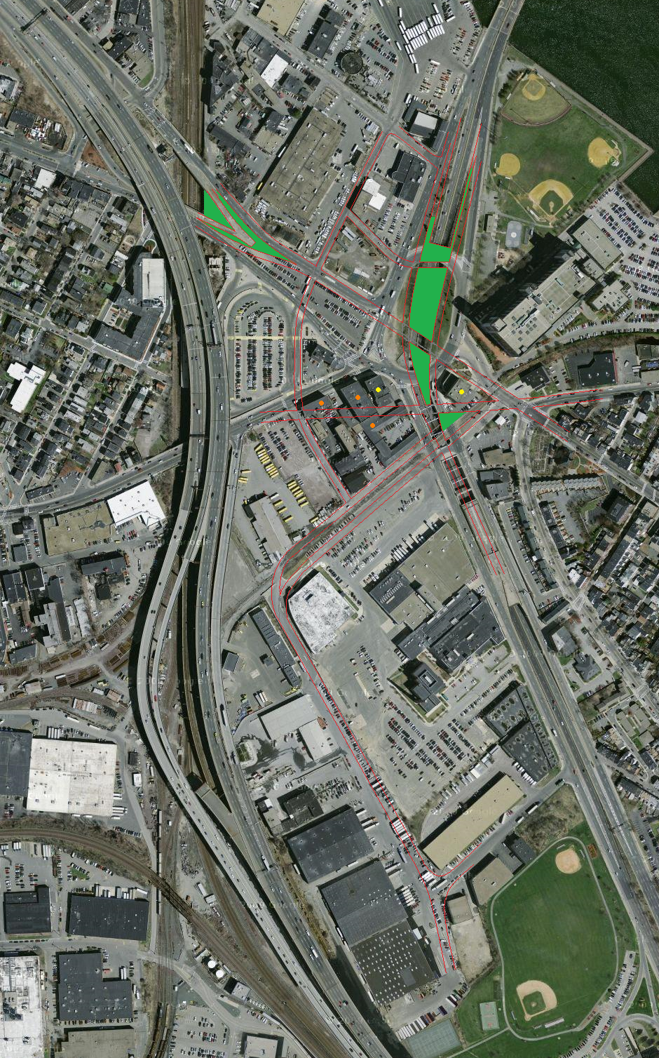
Charlestown’s Rutherford Avenue is a city street masquerading as a highway, a mid-20th-century relic scarred with chain-link fence, orange barrels, and Jersey barriers. Swelling to 10 lanes, split by a median, and nearly free of traffic lights, it invites speeds well over 50 miles per hour. Pedestrians and bicyclists approach at their peril.

On this much, nearly all agree: Rutherford is ugly, crumbling, and must be rebuilt. But the decision on how much it should resemble its old self is roiling the community. Three years into the planning, the debate is as pitched as ever.

Some want Rutherford to become a cross between Commonwealth Avenue and Southwest Corridor Park, a leafy boulevard flanked by a recreational path. Others want it kept mostly as is but rebuilt to last another 50 years and polished around the edges.

Advocates of the leafy option say it would be safer, prettier, livelier, and cheaper to build ($71 million versus $83 million) and maintain. They say it would also knit together divided neighborhoods.

Opponents say it will send drivers scurrying down side streets, seeking detours around the traffic lights.

“There’s nothing more important than this project in . . . making a difference for the neighborhood and making a difference for the city,’’ said Elizabeth Levin, speaking as a Charlestown resident, not in her capacity as a member of the board that oversees the state Department of Transportation. “And yet we don’t seem to be able to take that opportunity . . . because, for some reason, the change makes people nervous.’’

Neighborhood disagreement is common whenever plans emerge about reducing car lanes to accommodate bicycles and pedestrians, even when it involves aging, hulking urban highways like Rutherford, known to outsiders as the anonymous road that barrels past Bunker Hill Community College.

A similar debate flares in Forest Hills, where the state is considering removing the Casey Overpass. There, as with Rutherford, traffic engineers say a better-designed grid of streets and carefully timed lights can handle as much traffic as their counterparts, but residents are dubious.

The Charlestown debate has an added layer, falling roughly along “Townie versus Toonie’’ lines, dividing those raised in Charlestown and recent arrivals who have driven up home prices, those who pronounce it “Rootherford’’ and those who don’t.

Many skeptics have long memories, recalling past instances when government claimed to know best for the people of Charlestown: busing, urban renewal, construction of the towering, and lead-painted Tobin Bridge.

They say the more dramatic Rutherford revision is a ploy to open parcels hemmed in or covered by the existing road for development, generating city taxes while bringing more change - and traffic - to Charlestown.

At a recent meeting, the loudest applause came when Gerard Doherty, an octogenarian former legislator, compared the city’s windy, statistics-heavy defense of the reimagined Rutherford to Communist propaganda.

“Liars figure and figures lie,’’ said Doherty, who managed Edward M. Kennedy’s first Senate race in 1962. “We’re not going to leave - and we’re not going to leave this town - and we’re going to fight and do everything we possibly can!’’

The lack of consensus and distrust of the city has confounded supporters of the more dramatic redesign, which requires faith in traffic engineers. The plan would fill in Rutherford’s two underpasses - where some of its lanes dip below cross streets at Sullivan Square and again by the college - and reconfigure Sullivan’s rotary as a more orderly grid.

That plan appeared to prevail as the community’s choice in January 2010, after more than two dozen meetings with residents during 18 months. The Boston Transportation Department provided seed money for conceptual planning and intended from there to seek federal funds to refine the design and bid for construction.

Then opponents began rallying support - largely among those who had missed the planning sessions - and US Representative Michael Capuano, who represents Charlestown and sits on the House Committee on Transportation, weighed in with concerns of his own.

On its face, narrowing Rutherford and eliminating underpasses would seem to worsen traffic, especially with Sullivan Square already chaotic.

But, since completion of the Big Dig made Interstate 93 more attractive, Rutherford has four times as many lanes as needed even at rush hour, according to Mike Hall, traffic engineer with consultant Tetra Tech Rizzo.

Congestion instead is a result of a pinch point between two other streets merging at the rotary.

Meanwhile, the 2009 closing of the outbound side of the decaying Rutherford underpass also forced traffic into the rotary. A grid, plus improvement of roads in the lightly used industrial-commercial area around Sullivan Square, could ease traffic at Sullivan, said Hall and city officials.

“It’s a complicated thing,’’ said Mark Rosenshein, a member of the elected Charlestown Neighborhood Council, a City Hall advisory board. He is an architect who moved to town in 1998. “It’s not something you can sit down and listen for 10 minutes and get.’’

Bill Galvin, part of a minority on the Neighborhood Council opposed to the plan, said the city has rigged the process to produce results that will be cheaper to maintain and allow more development.

“I have a very, very healthy skepticism of government-hired - or anyone-hired - experts,’’ said Galvin, 68, a lawyer and third-generation Townie. “They have slanted everything to the surface option because that’s what they want.’’

Capuano’s staff participated in the planning process, but he did not raise issues until after it was over, when he approached the city with concerns the plan would worsen traffic. He convened his own meeting last spring that drew more than double any of the earlier planning sessions and gave a second wind to those who want to keep the underpasses.

That frustrated those who hoped he would press for what they view as a progressive plan.

But Capuano, whose support is key to winning federal dollars, said his role is to maximize constituent input. “Being involved is a good thing - as I am - but it doesn’t mean that the people who don’t go to every meeting get ignored,’’ he said.

Capuano said he hopes a compromise can be reached to preserve underpasses while also improving bike and pedestrian options. He bristled at the idea of outsiders claiming to know best.

“I wouldn’t like people from Charlestown coming to Winter Hill and telling me how to do traffic flow,’’ the former Somerville mayor said.

Boston Transportation Commissioner Thomas J. Tinlin said he understands if supporters of the more dramatic redesign feel fatigued, but the city wants to include everyone.

“This has been a long and sometimes arduous process, and tough slogging on occasion,’’ Tinlin said. “One thing I’ve learned in this city is I don’t think the process is really ever over until dirt is moved.’’

Eric Moskowitz can be reached at emoskowitz@globe.com.

Link
 
*throws arms up in the air* How can you possibly have a problem with this?
 
My favorite part was where Capuano said that he wouldn't want experts coming into his neighborhood telling him how traffic should flow. I see. And you also clearly never go to the doctor, since you wouldn't want an outsider telling you how your blood should flow. Would you allow an electrician into your home, or would that expert just be foisting dumb advice on how your electricity should flow?

The frustrating thing about transportation engineering (as a member of that field) is that everyone believes that they're an expert in it because they drive. Listen to these people and what they say about "figures" and "experts" and then review arguments against vaccines and evolution. Same crap. Figures can lie, but 60 years of blind ignorant experience lies more.
 
*throws arms up in the air* How can you possibly have a problem with this?

The problem is how slow the city works.

Boston has been working on three major street projects. Boylston (Fenway) + audobon circle, this one, and Central Square (East Boston).

Boylston got the "yay, everyone is in agreement!" all clear in 2009.

2009.
 
Capuano seems to have some sort of desire to murder his political career. In the past three years or so he has done almost everything he can to undermine what success he had as mayor. He's gone from a leadership figure to someone always overly eager to hop on an ill-thought trend after it's already gone sour.
 
The frustrating thing about transportation engineering (as a member of that field) is that everyone believes that they're an expert in it because they drive. Listen to these people and what they say about "figures" and "experts" and then review arguments against vaccines and evolution. Same crap. Figures can lie, but 60 years of blind ignorant experience lies more.

I was at a meeting last week where community members repeatedly demanded that every condo built in our neighborhood should have at least one parking space. They stated that in their expert opinion (as professional parkers) that this would ease pressure on spaces on the street.

I mentioned that traffic consultants have repeatedly stated in our meetings that increasing parking ratios generates more traffic and does little or nothing to alleviate pressure on the on-street resident parking spaces.

As you state, the view of our traffic consultants went nowhere.
 

Back
Top