Fenway Center (One Kenmore) | Turnpike Parcel 7, Beacon Street | Fenway

I don’t think this is true.

The MFA, Isabella Stuart Museum, Simmons, Emmanuel, Boston Latin, Winsor, and Harvard Medical all date to the 1900s or 1910s. Furthermore, the park through the Fens was laid out by Olmsted as early as 1887.

The filling in of the river to make a parking lot and construction of the big mass of roads especially where Brookline meets Boylston occurred in the 1950s.

Here’s a nice write up:
You’re referring to The Fenway and the handful of institutional development that occurred along Huntington Ave and the Forsyth Gate to the Fenway. I’m talking about Brookline Ave. Yes, the Necklace cut across it but the rest of Brookline Ave was always underdeveloped. Up through the 1940s there was a mess of rail yards just behind it and the Sears building; the development that did exist was industrial and there were huge undeveloped lots.

Much of Boylston St remained undeveloped as well. Those parking lots and fast food places did not replace any elegant walkups. The Fenway neighborhood was built out but the triangle between Brookline and Boylston was not… for a couple reasons, with one being the rail yards and the other simply being that there came a point when the rapid expansion in Boston stagnated and some areas just never got fully filled in.

And, if you look at old photos of the Harvard Medical area down to the Fenway, some angles look great, but many look strange. Because you had several (admittedly beautiful) institutional buildings constructed, but the area didn’t fill in. There were big chunks of undeveloped land all across what’s now the LMA, including right at Longwood & Brookline. Check out mapjunction.com, lots of great satellite and maps. The point is, Kenmore to LMA on Brookline Ave was never a walk anyone would’ve wanted to make.

One thing I did notice tho that I’ve never noticed before is that it wasn’t just the parking lot over the Muddy River that changed. If you look at the 1938 satellite view, the only road connections at Sears are Riverway the Riverway intersecting Brookline and Boylston, and then Park Drive on the far side of the river headed to Beacon. There’s no connection between Riverway and Park Drive on the north side of the parcel. It’s too bad because it’s that intersection that really poisons the area, despite the improvements to the day lighted parcel.
 
I don’t think this is true.

The MFA, Isabella Stuart Museum, Simmons, Emmanuel, Boston Latin, Winsor, and Harvard Medical all date to the 1900s or 1910s. Furthermore, the park through the Fens was laid out by Olmsted as early as 1887.

The filling in of the river to make a parking lot and construction of the big mass of roads especially where Brookline meets Boylston occurred in the 1950s.

Here’s a nice write up:
I agree. And it also looks like these areas were indeed connected before the construction of the pike. I compared a map from 1950 (which showed dense residential neighborhoods) to a current map (which shows the pike severing them) at this site: http://www.bostonplans.org/3d-data-...the-boston-atlas/single-sheet-historical-maps
 
Thanks. I thought “Fenway Center” was a broader development.
I looked up Fenway Center and it's a decent sized development of about 5 buildings in two phases. It's my opinion that a 22 story tower in this location should have its own thread (or at least be mentioned in the name of the thread).
 
I looked up Fenway Center and it's a decent sized development of about 5 buildings in two phases. It's my opinion that a 22 story tower in this location should have its own thread (or at least be mentioned in the name of the thread).
The people on this very thread have been discussing this project for fifteen years.
 
Nobody here asked about Fenway Center at all. You don't need to tell us about it in this thread when there's already another huge thread about it.
 
I agree. And it also looks like these areas were indeed connected before the construction of the pike. I compared a map from 1950 (which showed dense residential neighborhoods) to a current map (which shows the pike severing them) at this site: http://www.bostonplans.org/3d-data-...the-boston-atlas/single-sheet-historical-maps

The article byline suggests a past where there was a well integrated neighborhood running from Kenmore to the LMA. This is what is not accurate. This is not about zeroing in on one or another tiny part of this corridor (yes, you can look at the bulldozed north side of Mountfort St, or the collection of buildings on the south side of Fenway/Riverway intersection), but the overall corridor on either Brookline or Boylston was one of industrial buildings and vacant lots. There was dense residential in the Fenway neighborhood bounded by Peterborough and Park Drive, and there was residential along Beacon Street. Brookline Ave was entirely industrial, as I already said above, punctuated by large vacant lots. There was a multi-track rail line behind it. Boylston never was developed at all. It is an illusion to suggest otherwise. The responses here are only proving my point -- this was never a pleasant area. And that's OK. The interesting fact is that people seem to be in a mental mode of just thinking that every square inch of every city was perfectly compact, the paragon of enlightened urbanity, and that's not the case. I am glad the area is now finally being filled in, but this is the first time that that's happened.
 
I agree. And it also looks like these areas were indeed connected before the construction of the pike. I compared a map from 1950 (which showed dense residential neighborhoods) to a current map (which shows the pike severing them) at this site: http://www.bostonplans.org/3d-data-...the-boston-atlas/single-sheet-historical-maps
I look at the historical aerials from the 1930a and 50s, and I see that the crossings of the Pike are in the same amount and locations as before the Pike was built. Some strips of buildings were taken to squeeze in the Pike, but that was done on the periphery of neighborhoods, not through the middle of them. Not defending the Pike, but the fact that it ran in/alongside an existing rail corridor, plus the absence of very many on/off ramps, helped it to fit into the fabric of the city better than, say, the proposed Inner Belt Expressway to the south would have.
 
I look at the historical aerials from the 1930a and 50s, and I see that the crossings of the Pike are in the same amount and locations as before the Pike was built. Some strips of buildings were taken to squeeze in the Pike, but that was done on the periphery of neighborhoods, not through the middle of them. Not defending the Pike, but the fact that it ran in/alongside an existing rail corridor, plus the absence of very many on/off ramps, helped it to fit into the fabric of the city better than, say, the proposed Inner Belt Expressway to the south would have.
Absolutely. Although it definitely was less of a scar when it was rail lines (that is, at least up until Mass Ave -- people really are clueless on how the right side of Boylston was just this vast rail yard -- hard to believe). I wish there had been a way to preserve the left/south side of Washington St in Newton. It would be such a better urban corridor if they hadn't demo'ed that.
 
I wish there had been a way to preserve the left/south side of Washington St in Newton. It would be such a better urban corridor if they hadn't demo'ed that.

Exhibit A of what a ghastly impact ramming the Pike through Newton Corner/Newtonville had.

It's basically Newton's analogue to the Lone Tenement of Lomasney Way. If it had a pre-recorded greeting for visitors that blared over a loudspeaker, it would announce,

"Hello, here I am! 660 Washington Street. Somehow I am able to stay tenanted with this brave little jewelry shop, despite the fact that I am obviously a sad little vestigial remnant of what was once a vibrant high-density commercial district, before the Pike got rammed through this district, pulverizing all of my neighbors and leaving me the last pre-1965 commercial building standing."

The properties between Washington Street and the tracks along the pike have not changed since the tracks were first laid. The pike took out the south side, basically residential homes. map junction
 
The properties between Washington Street and the tracks along the pike have not changed since the tracks were first laid. The pike took out the south side, basically residential homes. map junction

Ah, sorry for my assumption, in that case. I'd been convinced for decades that 660 Washington had to be a remnant structure, given its proximity to the Pike, and how oddly, anomalously alone it stands on the south side of the street.
 
S&F concrete fb page

1678490270377.png

1678490288403.png

1678490306344.png

1678490326100.png

https://m.facebook.com/story.php?st...1QL7QhWpXfuWB9Tcc8DNxqJWyl&id=100063743776338
 
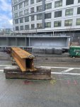
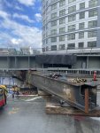
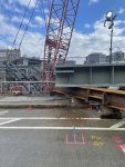
Steel now spans the EB highway. Also got some pictures of one of the largest beam single beams I have seen in my life waiting in the staging zone.
82AA6F90-CAE0-49D7-85F8-F34A3A8373E6.jpeg
 

Attachments

  • 1515352A-D817-47ED-A153-8B6E8465C42E.jpeg
    1515352A-D817-47ED-A153-8B6E8465C42E.jpeg
    2.4 MB · Views: 216
  • 90B681E7-958D-4C05-972E-6B5F7A8C3C40.jpeg
    90B681E7-958D-4C05-972E-6B5F7A8C3C40.jpeg
    2 MB · Views: 218
  • 3BE77ED5-42B5-4788-9C85-3145A3A28683.jpeg
    3BE77ED5-42B5-4788-9C85-3145A3A28683.jpeg
    2.3 MB · Views: 208
Interesting that this is steel, where Parcel 12 was concrete... though it looks from all the rebar like where will be concrete involved.

Im guessing vastly different structural engineering requirements... Parcel 12 is mostly on ground with the deck part being the plaza. This thing is a whole building going over the pike.
 
I've been wondering if it makes sense in these developments for MassDOT to replace these bridges simultaneously and incorporate them into the deck... I feel like it might be really challenging to replace the overpass once it's all tied into the sidewalk...
 

Back
Top