Fall River/New Bedford Commuter Rail (South Coast Rail)

Re: Fall River/New Bedford Commuter Rail

Well, yeah... that's why I argued a few posts above that it would make more sense to have a Providence--New Bedford commuter rail line, roughly traversing the I-195 corridor, versus the SCR proposal. Please revisit my earlier post and you'll see we're in agreement here, as far as I can tell.

I agree too: far better to subsidize the operating expenses of, say 4 daily r/ts that ran
New Bedford
Taunton
Attleboro
Providence
[Shore Line East]
New Haven

...same as the CT River Valley's going to get.

And then seasonal/weekend trains:
NY Penn - Providence - Taunton - Middleboro - Cape Cod
NY Penn - Providence - Taunton - Fall River

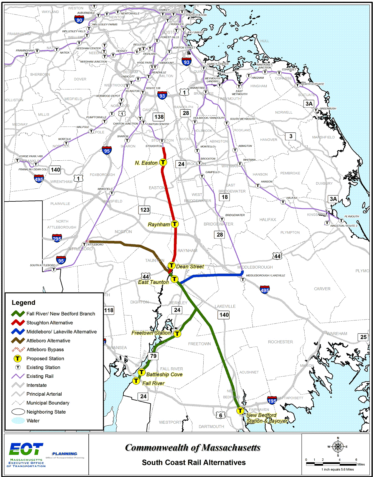
south-coast-rail-project.gif


If I had an extra billion for capital costs, I'd unpinch the Old Colony Lines and extend the Middleboro line to Taunton and cram it full of high capacity, high frequency service. (if I had frequencies to spare, it'd split and go to both Taunton and Wareham)
 
Re: Fall River/New Bedford Commuter Rail

Not seeing the Providence commute. Even if it was considered, that group in Norton
(CCATS) would rise up again and kibosh it. Not to mention the element in Taunton
raising the fear factor of their city being "cut in half". As I said in a letter to the Taunton Gazette years ago, you'd think MBTA trains were tattooed with "666", roaming around looking for hapless motorists and their precious "children".

It feels so hopeless sometimes....
 
Re: Fall River/New Bedford Commuter Rail

The line from New Bedford to Fall River was the Fairhaven Branch; it ended at Plymouth Ave about a kilometer from the Old Colony mainline on the waterfront, and was never connected to it.

And reactivating the line between Providence and Fall River would require building a major new bridge, just for starters.
 
Re: Fall River/New Bedford Commuter Rail

...indeed.

If the answer to 'but how do you get therefrom Boston' is 'standing in the aisle for 25 minutes on an express electric train on the nec after transferring across the platform in providence' then I think that's ok (and it's better than the red line!)
 
Re: Fall River/New Bedford Commuter Rail

No...The line from New Bedford to Fall River was/is the Watuppa Branch (13 miles long).
The Fairhaven Branch ran from Tremont to Fairhaven and never connected to New Bedford.

Any Providence service mentioned in this thread, would be north to Myricks, Cotely Jct through Taunton to Attleboro, then down the NEC to Providence.

D
 
Re: Fall River/New Bedford Commuter Rail

The problem of course is the bit about jurisdiction and authority

The T doesn't have authority in its charter which enables it to feed riders into Providence except for the Providence to Boston run

As a result some sort of agreement would need to be negotiated between MA and RI as to who pays for what, etc. -- Not insurmountable -- just another matter to be addressed if you route through Providence

Best solution now is robust and frequent service into Taunton with buses picking up in New Bedford, Fall River, U Mass Dartmouth, etc.
 
Re: Fall River/New Bedford Commuter Rail

The reasons you don't have any extant rail E-W rail lines paralleling I-195. . .

  • The Warren Branch out of Providence was carried over the Taunton River by the movable Slades Ferry Bridge, a lower-level road, upper-level rail bridge between Wilbur Ave. rotary in Somerset and Remington Ave. in FR (rail level abandoned 1938; demolished 1972). From Day 1 the bridge was extremely weight-restricted and too weak to carry early- 20th c. locomotive-pulled steel trains, so PRV-FR service only ran with gimp locos and wood coaches...then a short-haul electric commuter shuttle running wood EMU's under wires (basically, a glorified trolley interurban). All of the heavyweight intercity steam trains from New York that took all of NYC's richest to their Newport mansions had to go around-the-horn route instead: the ex- Amtrak Cape Codder route to Attleboro and downtown Taunton, then the Somerset Branch (basically the southern continuation of the Stoughton Line, crossing into Fall River on a drawbridge @ Mallard Point). And because the electric line ended at Fall River Depot it took a transfer to the Boston-originating north-south commuter trains to continue on to Newport.
When the Depression hit the Old Colony division hard and ridership on the commuter shuttle took a hit, they had no routes to consolidate all traffic to. So the electric Warren Branch got whacked because of that weak bridge that couldn't take any freight or non-shuttle passenger service. The freight between the RI state line and Somerset dried up too quickly for there to be any chance at landbanking, so it's only preserved in RI and completely one-million percent obliterated in Somerset.

  • The Wattupa Branch runs E-W between downtown New Bedford and Plymouth Ave. in Fall River, where it stubs out. Still active today NB to the MA 88 underpass in Westport, landbanked by MassDOT late-80's in FR after one of the end-of-line mills burned down. Old Colony meant to infill the last half-mile gap to the mainline by the river, but never got around to it. Then I-195 came along in the 50's and the City Hall air rights in the 60's, with no side reservation provisioned for filling the gap. So there was never real rail service between Providence and New Bedford except for the existing around-the-horn route via Attleboro-Taunton because of this chintzy gap, and no rail service between FR and NB except for a dinky to Plymouth Ave. isolated from Fall River Depot and any other transit options.

  • The Fairhaven Secondary and New Bedford main likewise stared at each other straight across the cove at separate loading docks with no foresight by the Old Colony to connect them. They probably could've done rail-with-road on the US 6 Popes Island bridge complex, with northern realignment of the Fairhaven Sec. from the Sconticut Neck Rd. grade crossing. But they let a couple generations of Popes Island crossing rebuilds come and go without ever acting on it, and let the abutting land on 6 get too built up to keep a future path open.


Consequently, you never had a means of consolidating enough traffic on one route to keep it all open through the mid-century decline. Providence-Fall River (direct, electric), Providence-Newport (indirect, steam), Providence-New Bedford, Providence-Cape Cod, and Fall River-New Bedford took FIVE different routings on five different schedules. With no real union stations collecting together these routes: the downtown Taunton station for the around-the-horn routes missed transfers to Boston, you had to walk across downtown to get between Fall River Depot and the FR-NB shuttle station, and frequencies from FR Depot to Taunton for transfers to NB and Cape were weak because most of the N-S traffic was Boston commuter trains that missed that particular Taunton station.


So you had the traffic profile of what should've been a major passenger and freight corridor Providence-Provincetown that: 1) should've retained trace passenger traffic until the same era (1958) that the 4 Boston commuter schedules lasted to FR/Newport, New Bedford, Hyannis via Middleboro, and Woods Hole via Middleboro; 2) should've retained trace seasonal intercity traffic into the Amtrak era and been one of the first modern (a la Cape Codder) revival routes picked back up; 3) should've been the primary freight route across the region keeping it all daily-active to the present. But there was never a contiguous corridor here...just this half-assed collection of parts that came oh-so-close but never connected because the Old Colony wasn't well-managed, especially during the 75 years to 1969 it was a wholly-owned subsidiary of the NYNH&H monopoly. The only fully contiguous E-W transportation route from Providence to the Cape for 300+ years from early colonial times to I-195's opening in 1955 was US 6. They were 98% of the way there on rail links but hemmed and hawed too long about the downtown Fall River gap and completely forgot about Popes Island. And that was that when the RR expansionary era came to a sudden halt in the 1929 market crash.


Did some very crude editing of the Old Colony system map on Wikipedia, with annotated legend of key lines.

Color code:
Purple = active passenger lines + SCR preferred alternative
Red = active freight/misc. lines
Maroon = converted to rapid transit (i.e. Ashmont/Mattapan)
Green = out-of-service non-abandoned lines
Yellow = abandoned, landbanked by state
Grey = abandoned, property lines extinguished
Dashed = line continues out-of-picture

This is what we started with, and ended up with in real life:
6fowg5.jpg


This is what we probably should've ended up with if just 3 itty-bitty things happened:
-- strengthen Slades Ferry Bridge
-- close Wattupa-FR Depot gap
-- close NB-Fairhaven gap

See magenta for the South Coast-specific lines with two green links for the gap-filler...and note the completely different slate of lines that would've been abandoned vs. kept. (Also threw in some other official passenger proposals in regular purple...but that's just extracurricular).

9tofv8.jpg


Oof!...that's just tragic. Could've consolidated everything at Fall River Depot as the union station for the whole South Coast where N-S Boston trains to Newport and New Bedford met E-W Providence-Cape and Amtrak Cape Codders. As well as the act as the freight crossroads for that region from the direct feed off the P&W main from East Providence. The straighter and somewhat more densely-populated Somerset Branch would've continued the Stoughton mainline, allowing abandonment of the branches through the empty Freetown State Forest. Consolidating the track miles and to just that crossroads at FR Depot + bare essentials probably would've allowed it all to survive the postwar crash and interruption in commuter rail service. Probably would've never completely lost service to Woods Hole because the ferries would've been that much more robust. Probably would've seen Amtrak come back to Cape Cod sooner than 1986, and stay there permanently. Probably would've never seen the Stoughton Line completely cut, meaning commuter rail by 1997 not 2297 and probably re-inaugurated service to Newport by 2010. Probably would be seeing RIDOT commuter rail back to Newport in quick succession after they get Woonsocket up in running...instead of never because the around-the-horn route is too indirect.


One thing you'll immediately notice is what bugfuck route duplication the Old Colony had all around its map. This is what they spent their capital on instead of fixing those chintzy little broken links that left us 3% shy of a complete and everlasting Providence-Hyannis corridor. It's a wonder they ever made it out of the 19th century solvent with such an easily distracted corporate attention span. But it's a goddamn travesty what didn't even survive the first half of the 20th c. because of those tiny links they brainfarted away. :(
 
Re: Fall River/New Bedford Commuter Rail

^Alot of the yellow lines have been converted to bike paths. For excample the Bruce Freeman rail trail and the Cape Cod rail trail.
 
Re: Fall River/New Bedford Commuter Rail

^Alot of the yellow lines have been converted to bike paths. For excample the Bruce Freeman rail trail and the Cape Cod rail trail.

Irrelevant factoid. Landbanking means the rail charter is intact in perpetuity and legally protected in perpetuity. The fact that nine-tenths of the yellow on those maps have no real-world reactivation potential worth wasting a Crazy Transit Pitch on is entirely beside the point. Legal status is legal status is legal status...now and forever.


Unfortunately it's the total-loss gray that prevents South Coast from ever having the consolidated corridors it should. You're never putting the Warren Branch back together in MA, and 'off-roading' re-creations along power line ROW's and I-195 are very ugly-looking and nowhere close to worth the price. Fairhaven's too built-up to spur off that intact ROW across Popes Island to New Bedford...blocked forever. And even if the I-195 canyon in FR were given a Wattupa Branch side reservation if/when that mistake of a City Hall gets knocked down and the Warren ROW were somehow re-created...the kajillions all that de-landbanking and all-new construction would cost would not produce sustainable E-W traffic justifying it unless Providence, Fall River, New Bedford, AND Cape Cod were all served on a single 195-corridor schedule with Fall River Depot being the union station crossroads of diverging N-S Boston & Newport traffic. 2 out of 3 links isn't enough demand to float the megaproject cost...and all 3 links are 1000% physically impossible to re-create.

It's a tragedy. The railroad literally wasted 120 years of its ownership monopoly over the entire South Coast rail network to each and every individual destination here kicking the can over and over again on the measly half-mile in downtown FR and the measly Achushnet River crossing that would've made it a complete super-corridor. The very first thing every chartered RR in the region--including the Old Colony's own mainline--went after were the revenue streams of the tolled colonial turnpikes. All of the turnpikes except the Boston Post Road spur from Providence to Cape Cod Canal along present-day US 6. That's not something a 19th century railroader robber barron "forgets" or loses interest in when they're 3% shy and have already built bigger drawbridges and tunnels all over the rest of the corridor. It literally defies explanation and everything we ever knew about the whole world economic history of for-profit private transportation that there was never 'A' completed rail corridor from Providence to the Cape replicating the turnpikes.
 
Re: Fall River/New Bedford Commuter Rail

You're never putting the Warren Branch back together in MA, and 'off-roading' re-creations along power line ROW's and I-195 are very ugly-looking and nowhere close to worth the price.... ...the kajillions all that de-landbanking and all-new construction would cost would not produce sustainable E-W traffic justifying it ...

Well...if the baseline is the $2B+ estimate for the swamp train to Taunton, then maybe there's at least some hope? [/rhetorical]

Thanks as always for the great info. (And there's another interesting story told in your maps about a framingham hub & clinton / fitchburg branch on the worcester route....for another day i guess ...)
 
Re: Fall River/New Bedford Commuter Rail

One wonders if light rail of some sort would eventually be palatable - something close to the early-20th-century interurbans. Instead of trying to plow through on fully-dedicated ROW with 2% max grades, you can get 4% grades and use city streets where necessary. Single-track with passing sidings.

If you're able to use the 195 median in the open space between Providence and FR, the Watuppa Branch between FR and NB, and the Fairhaven Branch + power line ROW between NB and Wareham, and city streets in the built-up areas, you're not looking at very much truly ugly construction. Approaches to use the Route 6 bridges across the rivers would be the big part. Battery-electric light rail, which is beginning to reach the 'actual systems are using it' phase, would mean no expensive and disruptive catenary.

Of course this is all still Crazy Transit Pitches level. But vastly more feasible than any kind of conventional commuter rail between the cities.
 
Re: Fall River/New Bedford Commuter Rail

Once again -- Nice recitation of the history, great maps

Nice comments about forever ROW -- except you forget the reality -- once a bike or hike trail it will never be anything else saith the hike and bike people who vastly outnumber / out-wail / out-fund raise any rail people

Same thing goes for anything related to swamps -- swamp-o-philes can even out-do the hike&bike set in fund raising and protesting

Moral of the story -- go into Taunton with high capacity and frequency -- major hub -- everyone else drives [kiss & ride / park & ride / zipcar and ride] or they take the bus to Taunton as the highways are already built and have plenty of capacity down at that end

I'm not forgetting the reality of de-landbanking. You have to apply the protected legal status against "forever" timetables. 100-year considerations are completely beyond prediction, so speculation is useless as to whether those bike paths are going to be there in 50 years or if some other urgent transportation need--reanimated rail, hyperloop, line-of-sight teleportation repeaters--is going to need the corridors for the good of the economy. Or if multimodal corridors are in the cards (after all, rail-with-trail's not exactly a rare thing). Nobody could've predicted in 1880 that the advent of commercial electricity would flip the Shawmut Branch in Dorchester on this very same Old Colony map to Red Line subway trains within 32 years, or predicted in 1913 that 2 World Wars and an economic sea change would've claimed the Milton Branch ROW in 40 years for the Southeast Expressway. That's the level of unprojectability we're talking about with "forever" legalities.

As I said, nine-tenths of that yellow has absolutely bupkis demand to hang a Crazy Transit Pitch on in 2016...or any future conditions we can make an educated guess on in 2016. But these are revokable 99-year trail leases, so anybody want to take a gander on what the year 2115 has in store for the South Coast? That speculation would be about as accurate at predicting in 1920 during peak power of the robber-barron railroad monopolies that those same ROW's would be hosting rail trails 90 years later. It's timetables beyond comprehension. We don't know anyone who'll be alive and participating in the Eastern MA or U.S.-at-large economy--whatever it looks like--in 2115...since the infants born in 2015 who today can't communicate in more than a half-dozen words almost certainly are going to be retired when they hit age 100. But those transportation corridors will still be chartered as transportation corridors when they turn 100. Maybe there will be a mission-critical need for a complete Providence-FR-NB-Cape corridor by then using some old, some new, some borrowed land. That's the whole point of landbanking laws: it's forever, and held for considerations beyond the date range anyone today is capable of predicting.
 
Re: Fall River/New Bedford Commuter Rail

Well said. All we can be certain of on the long timescale is that continuous long-distance overland corridors are going to continue to be really freaking useful for *something*...which is why the 'abandonments' on your map - and the never-closed short gaps (hard not to think of nsrl...) are the parts that are the real bang-your-head-against the wall frustrations

The Northside vs. Southside break at least has a rational and easily understandable explanation in differing ownerships. Boston & Maine didn't sell out the northside to the state and unify the Purple Line until 1976...exactly 40 years ago, and an event several posters on this board can personally remember as adults. The Old Colony--both the independent 19th c. company and the 20th c. semi-autonomous division of the NYNH&H colossus--had a monopoly on every single rail line south and east of the NEC and Fairmount Line from 1844 to 1969...a full 1-1/4 centuries. They got their start buying up North America's first ever railroad in Milton. They laid every stick of rail in SE Mass. They put the colonial toll turnpikes completely out-of-buisiness on present-day Routes 3A, 28, and 138 with the Plymouth, Middleboro/Cape, and Stoughton Lines.

But the Old Colony "forgot" about the Post Road spur turnpike, and never fixed those two tiny E-W gaps. For 100 years, it never filled the gaps. It can't be said enough: that defies all rational explanation. It makes zero fucking sense for economics of 200 years of for-profit railroading on Planet Earth. It makes zero fucking sense for the economics of 400 years of for-profit ground transportation in the Americas. It makes zero fucking sense for the economics of 2000+ years of for-profit ground transportation in the history of human civilization. Downtown Fall River and Acushnet River...does not compute. There's no hidden story to forensically uncover from evidence...no lost bets at a Freemason lodge...nothing. It just doesn't fucking make sense, and never will.
 
Last edited:
Re: Fall River/New Bedford Commuter Rail

OK...for reference's sake, here's the least-worst options for re-creating a Providence-Fall River/Newport connection. Keep in mind that this is hopelessly expensive, fraught with EIS'ing uncertainty, and probably isn't going to float itself on demand unless City Hall gets demolished + the I-195 canyon gets reworked so the Wattupa Branch can get a side reservation opening up Providence-New Bedford service.

Yada-yada too many expensive moving parts...you get the pessimistic picture and bottom-line futility in it all.:(

2dv7db9.jpg


All RI territory is de-landbanked existing ROW, and the new river crossing + hook-in to the Fall River Branch are on the footprint of the old ROW. Keep in mind that since MA 79 is going to be demolished for humongous TOD and park acreage between the NB and SB halves of Davol St. that the Fall River touchdown will be an unencroached nuke zone.

2 alternatives, both deviating off the Warren Branch ROW at the state line and crossing Wilbur Ave. to grab a very wide power line ROW. Our only saving grace here is that the whole area is THICK with power line ROW's thanks to Somerset Generating Station.

Alt. 1: Stick exclusively to power line ROW's (marked by double-ended arrows across map).

Advantages:
4.2 miles of contiguous land well-buffered from abutters. No private property takings. Easily acquirable from utility with no relocation of power lines. Straightest available path. Mostly level. Fastest track geometry. Accessible for construction via dirt access roads.

Disadvantages: 2 moderately large water crossings in Lee's River watershed w/ associated shoreline wetlands driving up cost. Couple adjacent residential subdivisions of possible NIMBY's. More EIS'ing unknowns throughout because power line ROW's aren't a pre-existing transportation corridor.


Alt. 2: I-195 median.

Advantages: All MassDOT land. Adequate median space. Sidesteps NIMBY pockets. Easier EIS'ing on 2 Lee's River watershed crossings by modding/augmenting existing 195 spans instead of building new.

Disadvantages: Lousy geometry, sharper curves, slower speeds. Warehouse property takings on Walker St. Close shave on Wilbur St. abutters. Complicated slip-on/slip-off to 195 median, with yucky wetlands impacts @ the Lee's River slip-on. Steel-and-concrete bridge construction costs over Lee's River same as Alt. 1, despite less-impactful EIS'ing. Caveat that highway median rail retrofits rarely pan out as simple in real life as the holy grail they look on-paper, so potential for unforeseen cost bloat.


The numbered placemarkers on the map show significant abutting structures or wetlands. Goes as follows:
1. Stony Creek Farm -- New ROW needs easement to split halves of property, needs farm grade crossing for tractors to access easterly field. Probably not a problem.
2. House -- Close shave of property lines, but no impact. Possible NIMBY.
3. House -- Slightly further away than #2. Possible NIMBY.
4. House -- Abuts power line ROW. No impact since now on ROW. Possible NIMBY. Other houses in neighborhood much better-buffered from power lines.
5. Wetlands -- Complication for EIS'ing Alt. 2 curve onto I-195 median. Curve geometry gets sharper, slower, more unfavorable the further away required to stay from riverbank.
6. Private easement -- Industrial abutter. Need easement through backlot. Not a problem.
7/8/9. Lee's River watershed crossings -- Perilous EIS'ing, expensive bridge construction. 8 & 9 could be one single structure instead of two.
10. Industrial abutter + 1 house -- Probably not long for this world once MA 79 comes down and Davol St.-facing redev becomes the motif for the waterfront. Expendable.
11. Bicentennial Park -- *Some* compromised access, but it already has two ugly electrical substations in the middle so being split by a rail viaduct wouldn't make it any less attractive.
12a-e I-195 overpasses/underpasses -- Lee's River watershed crossings would have to be doubled-up, median undercut on road overpasses.
13. I-195 slip-off -- Complicated because ROW has to diverge right at Brayton Point Rd. overpass. Reworking likely.
14. Residential abutters -- Not real close, but possible NIMBY's. Unclear if this meadow is wetlands.
15. Walker St. -- Splits industrial abutters; has to be taken for ROW. Land acquisition required, access disruption (but probably not outright demolition) to abutting buildings.
16-17. Multiple houses + businesses on Wilbur St. -- On old ROW, but zero buffer between backyards. Crappy low-income housing + auto chop shops, so NIMBY potential limited...but lots of properties affected by disruptive proximity.


There's probably no cost difference between the two. Alt. 1 has more EIS uncertainty, but much nicer track geometry if you can get it. Alt. 2 has shitty track geometry, but sure-thing EIS'ing. NIMBY problems not that significant because of sparse population density...more sorta close upper-class residential abutters in Alt. 1, bona fide land-takings and zero-buffer Wilbur Ave. abutters in Alt. 2. Pick your poison.

I kinda prefer Alt. 1 for being a flat-out better-performing rail route, and because I think pre-existing highway medians are a lot harder than they look to modify. The jump from the old ROW at the state line to the power line ROW is a turd-sandwich of a speed restriction, but it's unavoidable and at least gets its S-curving business over with quickly enough. But it's all moot because this just isn't a contiguous enough corridor to float its own demand, and will never be worth the money.

Oh, well...maybe in 2075 the demand picture will look different.
 
Re: Fall River/New Bedford Commuter Rail

Probably one of the reasons the gap in Falls River was never closed was because of the height difference between the waterfront tracks and the end of the tracks on the Quequechan River. Near as I can tell, it'd be a 130' drop over 3/4 of a mile, with no opportunity to lengthen the grade because of the millpond dams. Afterall, the falls that made Falls River were on the Quequechan.
 
Last edited:
Re: Fall River/New Bedford Commuter Rail

Actually plans were drawn for connecting the Watuppa Branch to the Fall River mainline. The tunnel portal would have been just south of Bowenville Station around Davol Street (I think). I have some copies of the plans packed away.

Another proposal was looping the line south of Fall River from the Watuppa Ponds and connecting with the Fall River mainline south of freight yards.

D
 
Re: Fall River/New Bedford Commuter Rail

E-mail "sent in error" shows the State may be leaning toward the Middleboro route:

Email shows state leaning toward Middleboro route for South Coast Rail

Posted at 9:30 AM | Updated at 9:42 AM
By Andy Metzger/State House News Service


...

The email said that MassDOT believes the project should be implemented in stages, with phase one including a new Middleboro Station - which would be near the existing Lakeville station - and stations in East Taunton, Fall River and New Bedford.

"Phase 1 will extend MBTA commuter rail service on the Lakeville line to New Bedford and Fall River, along the Middleboro Secondary from [Pilgrim] Junction (Middleboro) to the terminal stations at Whale's Tooth and Fall River Depot, providing a one-seat ride," the email states.

Service would include two peak-period diesel trains to Fall River and New Bedford, according to the email. Construction of additional stations - Freetown, Kings Highway in New Bedford and Battleship Cove in Fall River - would be deferred, according to the email.

The email was sent by MassDOT legislative director Michael Berry. On Tuesday evening, James Eng, MassDOT's deputy administrator for rail, wrote a follow-up email, according to MassDOT, calling the earlier email "factually inaccurate" while advising that if the "Middleboro option would mean South Coast service sooner and more cost effectively, we would be interested in exploring it further."

...

Pollack said there is no "final information" about the cost or timeframe for pursuing the Middleboro route. The transportation secretary said she and others want to make a decision on which route to pursue "in the early part of this year."

Another wrinkle to the Middleboro option is that Middleboro-Lakeville, which is now the end of a commuter rail line, already has a station. The existing station in Lakeville, which is not situated along the route to Fall River and New Bedford, also has a housing complex next to it.

"They'll be pretty livid that that's not the station," Pacheco said.

Straus said the existing station is only a quarter mile from the site of the proposed new station, and a shuttle or walking path could be built along the rail-bed to the new station. Straus also said the vast majority of people who use Middleboro-Lakeville drive to the station.

...

Full article: http://marion.wickedlocal.com/news/...-toward-middleboro-route-for-south-coast-rail
 
Re: Fall River/New Bedford Commuter Rail

E-mail "sent in error" shows the State may be leaning toward the Middleboro route:

This approach is 100% correct and I'm glad they're apparently pursuing it. Do a bare bones set up initially with basic stations instead of building the Taj Mahal at each stop. The stations you need are NB, FL and Taunton. Taunton at the junction near where 24 and 140 meet, FR and NB as discussed in the article. You don't need Freetown anytime soon. Nobody lives there and its close enough to the other stations. I'd really like to see an updated cost estimate on this as I feel this approach was dismissed too easily when Devalue Patrick and crew were pushing the Stoughton approach which will never happen due to the environmental mitigation through a swamp where the residents claim Big Foot might live (that was actually written in the Globe once, not making that up).
 

Back
Top